I actually had hopes that somehow, in some unbelievable fashion, I would get my long wanted pilothouse sailboat for a present. Maybe under the tree would be a little card in a plain manila envelope, and inside would be a photo of her at a dock somewhere. There would be a big red bow on the cabin roof or around the main boom. "Pop" goes the bubble of my dream world, Christmas has come and gone, and I'm still waiting for my new boat (new to me) to magically appear. If you see my new boat out there somewhere, please let me know, I really need to start outfitting her for next summer's cruises.
BTW my birthday is in April.
See my belated Christmas present >> New Bombay Pilothouse Project
Tuesday
Why go to Cypress Island? Just go somewhere else - Please
I hesitate to write about Cypress Island, my impulse is to keep the secret.
For some, Cypress Island is a destination. For others it's just a stop on the way to somewhere else.
For me, it's a dependable refuge that I return to again and again.
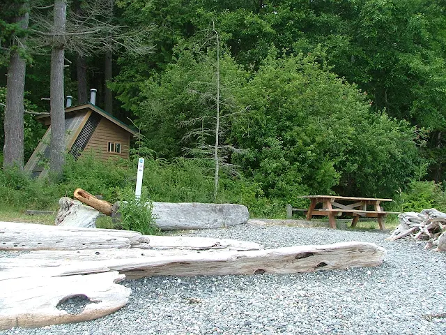
This selection of images is from Pelican Beach on Cypress Island. The beach is very dinghy friendly. Pelican Beach should be visited for one hour or overnight, or you are missing out on something truly special.


For some, Cypress Island is a destination. For others it's just a stop on the way to somewhere else.
For me, it's a dependable refuge that I return to again and again.
This selection of images is from Pelican Beach on Cypress Island. The beach is very dinghy friendly. Pelican Beach should be visited for one hour or overnight, or you are missing out on something truly special.


Find your own trail on Cypress
Please use this link for all the other parks and keep Cypress secret.
Thursday
Using Current Charts Will Get You a Free Ride in the San Juan Islands - Riding the Current North in Burrows Bay
Who ever said there's no free ride has never been to Burrows Bay. If you are a kayaker and your kayak paddle is getting heavy, or your in a putt-a-putt puttster boat and need another knot of speed, you should know that the current pretty much always flows north in Burrows Bay.
Don't believe me, check your current atlas and find a day of the year or time of day that the current is forecast to flow south.
Burrows Island and Allan Island are strategically located to create a whirlpool counter current within the bay, so along the shore is a dependable northward current at all times.
What this means is that when you are cruising from Deception Pass north to Anacortes, or anywhere north, in Rosario Strait, it will pay you to come in close to the eastern shore and get a little boost. Of course if you're heading south you should stay out in Rosario Strait.
 Hugging the shore in Burrows Bay will get you about 4 miles of free current to ride. Wouldn't it be great if all the channels and passages were this helpful, this back and forth tidal thing is nice, but doesn't always keep to my schedule.
Don't believe me, check your current atlas and find a day of the year or time of day that the current is forecast to flow south.
Burrows Island and Allan Island are strategically located to create a whirlpool counter current within the bay, so along the shore is a dependable northward current at all times.
What this means is that when you are cruising from Deception Pass north to Anacortes, or anywhere north, in Rosario Strait, it will pay you to come in close to the eastern shore and get a little boost. Of course if you're heading south you should stay out in Rosario Strait.

Saturday
How Small of a Boat is Too Small, for the San Juan Islands?
Using common sense and smart practices, just about anything that floats has a time and place. Hobie 16's - 14's - inflatable kayaks, canoes and hundred foot palaces, all work for cruising and boat camping in the San Juan Islands.


If you look in the background of these three pictures, you see calm tranquil waters
While its true much of the summer you can expect these conditions, you should still be prepared for some nastiness.
Being prepared sometimes means simply changing your schedule so as to not get caught in the middle of Haro strait during a blow. Or worse, accepting your fate and being forced to spend an extra night at Jones Island, or Rosario while the weather gods sort out the big plan.
If you travel light and are flexible, sensible and not too foolhardy just about any boat is suitable for travel in the San Juans.
We once passed a couple of young men paddling their becalmed little 16' sloop part way between San Juan Island and Stuart Island. The current was helping them along at about 1 mph and they had six or more hours of daylight left. Later that afternoon we noticed they had tied to the dock a few boat lengths down from us, apparently none the worse. That night one slept on the dock and one in the boat. The next morning they were comparing who had the most uncomfortable sleep.
Sometimes we see groups in open long boats from local camps, they will come ashore to unload gear and then using an anchor and long rope loop, pull their boat out to deep water for the night.
I have seen ski boats so overloaded with camping gear and people that they have no reserve buoyancy, essentially they are waiting for a rouge wave or wake to sink them. Small boat cruising is perfectly acceptable, but you still must follow basic boating seamanship and safety rules.
A sailing partner of mine in Portland wants to bring his Hobie 16 to the San Juans. My first thought was --your going to freeze to death-- but then I remembered he uses a wet suit. He asked if I thought a 1 hp outboard could be rigged up for an auxiliary (about 25 lbs I think) I said why not, as long as you don't weigh yourself down with camping gear, all you need is 1 hp, a gallon of extra fuel, wet suit, booties, gloves, hand held waterproof VHF radio, and a dry bag (or two).
But if he flips the boat and needs help, he could be in trouble and all Hobie Cat sailors like to fly a hull. I suggested he travel in company with other boats, so they could carry his camping gear and cruise nearby for emergency's, just in case.
We came across a family with a dog in a canoe halfway to Patos Island, gutsy or foolish, maybe just ignorant, but they were a long way from land.
I have never seen a paddle-board being used to cruise, but I'm sure I will.
Sunday
Seven important rules to be aware of when boating back and forth between the US and Canada
Dealing with customs;
About the most important point I can make is that you should not let customs check-ins impact your plans. Except for the obvious route planning details, its not a big deal. Some places in Canada you can check in after hours using a special phone on the dock.
You will need to check in with Canada customs when you enter Canada; you will need to check in with US customs when you come back to the US. When you depart either country you don't do anything except leave.
There are some rules that you or your crew may stumble over, and they apply going into both country's.
- When you enter Canada and come back to the US, you must not stop anywhere (no parks, gas docks, bathrooms, nothing) until you have checked in, even if it means traveling hundreds of miles out of your way.
- You may pass through without checking in if you don't stop anywhere. This means you can sail over the international property line, circle around and come back, and no one cares. It also means you may sail all the way to Bellingham (skipping Roche) to check in, but you may not stop anywhere, (even to get fuel at Orcas) You may run all the way to Alaska, just don't stop without checking in.
- "Checking in" means to go to a port of entry where they have a customs facility and tell them.
- When you arrive at the red painted customs dock everyone must stay on the boat, only one person goes to check in. (no, your crew may not run down to the bathroom until after you're checked in)
- Bring with you to check in; birth certificates, visas, passports, name of boat, names and ages of all on board, name and registration number of boat.
- They will ask you questions; where you live,where you been, where you going, purpose of visit, how long, etc.
- You can't stay at the red painted customs dock, after checking in you will need to move on, sometimes at Roche Harbor for instance the boats will be stacked up circling, waiting for a spot at the check-in dock.
That's it, real simple, fast, and very inconvenient if you now have to back track miles and miles to your favorite island, but that is why we plan our route.
Rules and requirements probably are changing as you read this, so you should probably make some phone calls or search online for new info.
- Not checking in at all, may have severe consequences. In today's heightened alert, they take things seriously, but it is not difficult to check in.
Wednesday
Does Paying It Forward Work? (like money in the bank) How to get yours!
Paying it Forward - Fact or Fiction.
Have you
ever noticed someone parked beside the road, most likely broke down? Is everyone flying by, rushing to their next piece
of life? Sometimes you will see a Good Samaritan
pulled over offering help. There’s a
certain concept floating around, that if you help someone out of the goodness
of your heart, it’s like putting money in the bank so to speak, money you will
draw upon in the future in your own time of need. Often called, “paying forward”
Sound about right, right. Well not
really, if you’re just banking goodwill, then it’s not really out of the
goodness of your heart.
Enough philosophy, “paying it forward” is alive and well in the boating world, and especially among cruisers. If you are a newbie to cruising or boating you may be hesitant to offer a helping hand, don’t be. The people in distress will appreciate the offer and may well be hoping someone would help them out. Help can be as simple as handling a dock line when they arrive to helping rebuild a balky pump, or giving a tow.
 |
| Turn Point lighthouse on Stuart Island |
Last summer at the Matia Island dock in the San Juan's, a cruising couple appeared at our boat early in the morning while I was having coffee in the cockpit. They gave us a large chunk of warm carrot cake. It was delicious, hitting the spot perfect. Possibly I was receiving some interest on my account, what do you think?
Sunday
10 things Experts say you need for Sailboat Cruising
1. Sailing Knife and Marlinspike
Carry a
knife and marlinspike on your belt at all times (not in your pocket, and
not down below in your bag). You need it ready to use in an instant. A
knife will cut through sailing rope or free a Genoa sheet wrapped around
your leg. The marlinspike helps pry open strands of rope for splicing.
Folding knives with a 3" blade and marlinspike are fine, but require two
hands to open and close. A better choice would be a straight blade,
rigging knife with a 3" blade and a separate marlinspike in a sheath.
Always,
always secure a knife with a lanyard to your belt. This keeps it
attached to you even if it slips out of your hands. This can be critical
if you have to go aloft or slip over the side with a rope wrapped
around your leg (this has happened more than once to sailing crews offshore!)
always secure a knife with a lanyard to your belt. This keeps it
attached to you even if it slips out of your hands. This can be critical
if you have to go aloft or slip over the side with a rope wrapped
around your leg (this has happened more than once to sailing crews offshore!)
2. Personal Flotation Device (pfd) and Sailing Harness
Pack your own pfd and sailing harness. Do not rely on sailboat you
crew aboard to have a spare. Try on several inflatables and find one
that's easy to adjust and comfortable. Simulate sailing motions when you
put it on. Squat down, lean over, raise your arms above your head, and
pretend you are grinding on a sailing winch. It must hug your body and
give you comfort at all times; otherwise you will not wear it!
Purchase
a separate sailing safety harness. Better, find an inflatable pfd with
an integrated harness. Make sure it has oversize D-rings rated to a
breaking strength of at least 4,000 pounds. A separate harness should
mold to your body like a glove. Again, do not rely on the sailboat you
will board to provide you with a safety harness that fits your body.
Ask
the sailing skipper if there are tethers already onboard. The tether
attaches to your harness D-ring and then clips on to a jackline ( a long
piece of line or webbing that runs from bow to stern). If you need to
make your own, use webbing or three strand sailing rope. Make one tether
4' long and the other 6' long. Attach strong one-handed clips with a
breaking strength of at least 4,000 pounds to the end. Attach the other
end to the harness D-rings with an oversized snap-shackle. Attach a
lanyard to the snap shackle for quick-release, in case your tethers get
hung up and you need to shed them fast.
3. Caps and Hats
You
need protection from the sun, the cold, and rain. Double everything you
pack for cats and hats. You can expect to lose at least one hat over
the side on each trip. Pack two peaked caps, a good brim hat, like those
made by Tilley, and two or more knit watch caps. A good brim hat
provides more protection in the Tropics than slathering sunscreen on
your face and neck.
At nighttime, even in summer, the sea weather
will cool more than you ever thought possible. A good watch cap will
keep you warm. Those made by a company like Under Armour are microfibers
that breathe and provide comfort without sweating (which will cause
your body to cool!).
will cool more than you ever thought possible. A good watch cap will
keep you warm. Those made by a company like Under Armour are microfibers
that breathe and provide comfort without sweating (which will cause
your body to cool!).
4. Foul Weather Gear
Pack a full
set of foul weather jacket and bib-pants. Match the jacket and pants to
the type of sailing. Use lighter gear for tropics and heavy gear for
cold weather passages. Go for the "breathable" type fabrics that protect
you, but allow air to circulate next to the skin to help lower
perspiration.Ask the sailing skipper if you should bring sea-boots.
5. Under Garments
Pack
thick, heavy socks to wear with sea boots. These protect your heels to
ward off blisters. Under layers should be considered part of any foul
weather gear offshore equipment. You need garments that wick the sweat
from the skin to keep you dryer and prevent cooling. In warm or cold
weather, go with the modern microfiber synthetics for superior comfort
beneath your foulies.
6. Sailing Gloves
Unless you
sail all the time, your hands will not be used to handling the sailing
ropes of synthetic material common on sailing yachts. These can cause
blisters or "rope burn", where the line runs out fast between your
hands, peeling away the skin.
sail all the time, your hands will not be used to handling the sailing
ropes of synthetic material common on sailing yachts. These can cause
blisters or "rope burn", where the line runs out fast between your
hands, peeling away the skin.
Purchase full length sailing
gloves--also called "3/4 length"--that cover all except the tips of your
fingers. These offer the best protection when working sailing sheets,
halyards, and boat anchoring rode.
gloves--also called "3/4 length"--that cover all except the tips of your
fingers. These offer the best protection when working sailing sheets,
halyards, and boat anchoring rode.
7.Oversized Plastic Freezer Bags
Crazy
as it sounds, zip-lock type bags are worth their weight in gold. Pack
10-20 of these. Use them to segregate clothes so you don't have to dig
in a bag (i.e. one for socks, one for underpants, one for t-shirts) Use
them for dirty clothes to cut down on odors. Seal wet clothes inside
until you have a chance to dry them. Fill them with valuables like your
wallet and cellphone. Zip up snacks inside for late night watches or
quick meals when it gets rough.
Make any zip-lock type bag more compact or keep foods fresh longer with these three easy steps:
1. Seal all except one half inch of the bag. Press as much air out of the bag as possible
2. Insert the straw into the opening. Seal the bag next to the straw with your fingers.
3. Suck on the straw to remove the rest of the air. Seal the bag as you withdraw the straw.
1. Seal all except one half inch of the bag. Press as much air out of the bag as possible
2. Insert the straw into the opening. Seal the bag next to the straw with your fingers.
3. Suck on the straw to remove the rest of the air. Seal the bag as you withdraw the straw.
8.Personal Grab-Bag
If
you need to leave the boat in an emergency, you need one bag that you
can grab-and-go. Use one of your zip-lock bags for storage. Include your
wallet, keys, passport, visa, cellphone, a separate notepad with a list
of emergency contact names and phone numbers (this should include your
insurance policy # and phone numbers, doctors name and numbers, pharmacy
numbers), cash, travelers checks, and at least 10 days of medications.
9.Seasick Medications
Pack
some form of seasick prevention for any offshore trip. More than 66% of
all sailors experience some form of seasickness (mild to severe) in
rough weather. You must be able to stand watches, help with sail changes
or reefing, and work with the sailing crew, even when you aren't
feeling your best.
some form of seasick prevention for any offshore trip. More than 66% of
all sailors experience some form of seasickness (mild to severe) in
rough weather. You must be able to stand watches, help with sail changes
or reefing, and work with the sailing crew, even when you aren't
feeling your best.
Use the mildest type of seasick remedy that
gives the maximum effect. Start with natural, non-medication forms of
seasick prevention (ginger, emotional freedom technique (EFT),
wrist-pressure bands). Next, consider over-the-counter types of
medication. If necessary, use prescription medications.
gives the maximum effect. Start with natural, non-medication forms of
seasick prevention (ginger, emotional freedom technique (EFT),
wrist-pressure bands). Next, consider over-the-counter types of
medication. If necessary, use prescription medications.
Check with
your doctor before taking any type of seasick medication--even the
natural forms. Each individual has a different body chemistry, and you
want to be on the safe side. Start your medication at least 24 hours
before you set sail so that it will be in your bloodstream before you
leave the pier. Keep hydrated at all times to lessen the onset of
seasickness.
10.Hand and Head-band Lights
Carry your
own flashlight. Buy one of the small high-intensity lights that come in a
sheath. Look for those with pop-on, pop-off red filters. You need red
filters to keep your night vision in tact. In addition, purchase a
head-band type light with the same features--high intensity white light
with a toggle for red filtered light.
Use the head-band light for
hands free chart navigation, engine space maintenance, and to check sail
trim at night. Pack at least three changes of batteries for each type
of light. Buy a plastic soap dish, place the batteries inside, and strap
them shut with heavy-duty rubber bands.
hands free chart navigation, engine space maintenance, and to check sail
trim at night. Pack at least three changes of batteries for each type
of light. Buy a plastic soap dish, place the batteries inside, and strap
them shut with heavy-duty rubber bands.
Use these ten sailing
tips to know the absolute essentials you need to pack for any offshore
sailing trip. You will be able to enjoy your time underway worry-free,
with the knowledge that you are ready for whatever comes you way!
tips to know the absolute essentials you need to pack for any offshore
sailing trip. You will be able to enjoy your time underway worry-free,
with the knowledge that you are ready for whatever comes you way!
================
Courtesy of: Captain John teaches sailing skippers the
skills they need to learn to sail like a pro! Get his popular free
report "Ten Top Boat Safety Checks for Cruising Boat Skippers" at Learn to Sail at Skippertips.com.
Courtesy of: Captain John teaches sailing skippers the
skills they need to learn to sail like a pro! Get his popular free
report "Ten Top Boat Safety Checks for Cruising Boat Skippers" at Learn to Sail at Skippertips.com.
John
offers a free weekly sailing tips newsletter. Join his site to learn
hundreds of little-known sailing tips and techniques with articles,
videos, and live sailing forums at Learn to Sail at Skippertips.com.
offers a free weekly sailing tips newsletter. Join his site to learn
hundreds of little-known sailing tips and techniques with articles,
videos, and live sailing forums at Learn to Sail at Skippertips.com.
Thursday
Dragging Anchor on the 4th of July Minutes Before the Fireworks at Roche Harbor Was a Near Disaster
You Don't Want to Miss Fourth of July at Roche Harbor This was going to be the best boat trip ever. We are headed to Roche Harbor in the San Juan’s where we will join in the fun celebrating with 1,000’s of boaters from all over the Northwest and beyond. And it really was a great trip, just not the one expected. Roche Harbor (yes, pronounced “Roach”) is a destination resort for boaters and non boaters alike, nestled on a fairly large protected bay on the northwest corner of San Juan Island in Washington State.
Our trip starts in Portland, OR where we live. But our boat, a 28 foot sailboat, is moored for the summer in Anacortes WA. Having done this 275 mile drive many times, we had developed a system and are not in a hurry, after all we are on vacation. We left Portland late in the morning, breezed through Seattle traffic and arrived at Cap Sante Marina in Anacortes ready for dinner. The first thing we do is make sure “Windsong” is still floating in our leased slip and that the batteries are fully charged. After checking out the boat and stowing all our "must have" gear and toys we head for one of the many restaurants we have become familiar with. When we first started exploring Anacortes some locals had recommended the bowling alley as the best place to get a good and sizable meal, and I can’t disagree, but we thankfully found that other places deserve our business as well, especially if some sort of ambience is on your menu. It usually takes all day on the road and a meal in a strange city before the kids start realizing we are off on another boat ride and start offering advice about what to stock up on for provisions. Don’t forget coke and chips and trail mix and cookies and hot dogs and everything else. So it’s decided once again, everyone will help with the shopping. After dinner we park in the parking lot at the top of the ramp leading to the boat, and we split up. I haul another load to the boat while the rest of my crew walks across the street to “Safeway.” Having a major grocery store nearby is a great benefit. By the time I get to the store they have filled a cart with a week’s worth of really wonderful great stuff. Where’s the fruit, wine, cheese and M&M’s I want to know. It’s getting dark as we haul our loot across the street and down the long floating walkway to the boat. It’s never boring at a moorage, there is always someone to talk to, some weird strange floating craft to look over, something in the water to check out. We finally get everything packed away, “Windsong” is sitting much lower in the water, the children have staked out their over lapping territories, the moorage has become quiet, and we can hear muted conversation drifting across the calm water. It’s time to open a bottle of wine and relax in the cockpit, “no I say” you can’t have a coke, as I pull out the cork.
Morning comes early for me. As I wake up I think once again of a quote I read that went, “All boats under fifty feet are designed for just two people” and I think to add “and only if the two people are a couple.” I slide the hatch open to see, not sunshine, but fog, which means grab a coat, everything is wet and cold. Hopefully this is the last time I walk up the ramp today. Inside the Safeway is a Starbucks, where I purchase two steaming cups off strong black coffee. I really, really, don’t like Starbucks coffee. A baker’s dozen donuts to go, and I’m back at the boat with breakfast. A quick final check of boat systems and I cast off, Linda is up, Jaiden and Kailey are still asleep; or at least they pretend to be asleep, the idling diesel motor is noisy, bangs, shakes and rattles everything within its reach. Windsong moves effortlessly through the still water leaving no wake, at 1450 rpm the motor is smooth and without vibration, time for coffee and donuts. Roche Harbor is about 26 miles, six or seven hours motoring, even longer, or not even possible if we sail. Today is the 3rd of July and we plan to spend the night at Jones Island Marine Park. Normally sailboat travel in the San Juan’s involves planning your trip around constantly changing tides and currents, which make a big difference in the time it takes to get somewhere and the fuel you use. But for us, this is the second day of our vacation and we’re heading out regardless of current. Almost immediately we are swept into the outgoing tidal current and are whisked along at twice our normal speed. Ah, good planning skipper. The fog is limiting our visibility as we cut across Rosario Strait heading for Thatcher Pass. We don’t have radar and I don’t want to be near any ferries so I take a somewhat northerly course. Of course now the current is pulling us sideways right into where I don’t want to be. More good planning skipper. We have a reliable GPS that will help keep us off the rocks. The fog is pea soup now, visibility is only a hundred feet or less. Just three or four times the length of the boat. We are essentially running blind. As we approach Thatcher Pass I maneuver very close to the invisible shore. Everything is white and I am dripping wet from condensing fog. What a great trip. We are constantly monitoring the depth sounder and GPS, staying in shallow water we work our way further into the pass. The boat is moving slow as we feel our way along. I’m glad the current is against us now or we would be pushed along faster than we could stop or turn should we need to. Our senses are acutely tuned to the situation at hand, I know the ferries can’t come this close to shore, my worry is other nuts like us groping blindly along. If we encounter a boat moving fast we will collide before we can take action. Suddenly the fog begins turning more white and bright, it is hurting our eyes. In a matter of a few feet we slip into a bright sunny day. Visibility is unlimited, we are a few hundred feet offshore. (too close)
The rest of the way to Jones Island is pretty routine. We pass by Friday Harbor, steer clear of several ferries, and lots of boats. All of Jones Island is a Washington State Park, and my favorite place to visit.

The cove is protected, the dock is long enough for six or so boats, and there’s plenty of room to anchor. On shore the deer are friendly and some will let you pet them. There are campsites and fire pits, running water, toilets, trails. Roche Harbor is just a short ways further, we will leave around noon tomorrow, I want to get there in time to claim a good spot to anchor, and then dinghy to shore to visit the sculpture garden. The flag ceremony will be at sundown, for several years I have wanted to be at the flag lowering and watch the color guard. I know they fire a cannon as part of the ceremony. We are in luck, a boat is pulling away from the dock as we enter the cove at Jones, Minutes later, “Windsong” ghosts up to the only spot available and we toss our lines to willing helpers on the dock. We are set for the night. Jaiden and Kailey head for some tide pools still exposed from low water.
Linda and I take off on the trail across the island, we see several deer in the woods. The campground on the other side of the island is used mostly by kayakers because it has no dock and the cove is not very big or protected. Sometimes we see groups huddled behind tarps trying to get out of the wind. We wonder if they know that they can paddle around to the other side where there is no wind at all and lots of great campsites. We pick a hand full of apples from the small orchard and walk back into the woods planning to feed the deer. The apples are not ripe, they are small and very hard. I’m not so sure they like them this early. As we walk back towards the cove we try to hand feed a deer but it shies away. I leave some cut up apple pieces on a log. The next day I see the apple pieces are still untouched, the raccoons must not be fond of tart fruit either. Sorry guys, All I have on the boat are M&M’s and chips. Jaiden and Kailey are busy on shore with some new friends, this is a good time to do some reading. Tonight we have a campfire in one of the empty campsites and then sleep comes easy for everyone, it has been really exhausting doing nothing all day. In the morning I want to sleep in but the desire for our own coffee gets me up and soon we have our drip coffee maker happily sitting on the burner. It seems to take forever for the 12 cups to drip into the pot. At home we have a timer and the coffee is ready when I get up. This camping is cruel. Finally cup in hand I walk down the dock, other boaters are up and about, some are leaving for parts unknown. Some boat campers are on shore in tents. The dock has a spot designated for dinghies, used by boaters that are anchored. Dinghy docks never have enough room so boaters just tie their dinghies as best they can. Windsong is tied up in a 30 minute parking/loading zone between the hours of 8:30 am to 3:30 pm. It’s getting close to 8:30 and one of my crew is nagging me to do something. Luckily the boat in front of us soon prepares to leave and as he pulls away from the dock I simply pull Windsong forward to the newly vacant space. “Happy?” I say to the crew. Now we can park for 14 days.
Today is the fourth of July, Roche Harbor is just a short distance from Jones Island. I’m sure that boats are already arriving at Roche by the hundreds, some will have reservations at the dock made a year in advance. The overnight fee is $1.50 per foot. Windsong would cost $45 per day but there’s not a chance in the world that space is available. Our plan is to anchor as close as possible so rowing the dinghy is not too hard or far. It’s time to go I decide, everyone that needs to go ashore better get going, we need to leave. Suddenly I’m in a rush, the anxiety of not knowing our accommodations at Roche has got me tensed up. This is not why I go boating. I’ve checked my current charts and tide predictions, but once again it doesn’t matter which way the water flows, were on a mission, a quest. Hurry up, lets go. We must get to Roche Harbor and stake out our place to watch the fireworks, then go ashore for the flag ceremony. Soon enough Windsong floats across the shallow short cut on the east side of Pearl Island and we get a full view of the bay at Roche. Wow, what a sight, boats are everywhere. There must be a billion dollars worth of RV’s floating around us. I spot some Ocean Alexander yachts that I think sell for a million. (Years later I find out $15-20 million is more like it)
We see a motorized barge anchored with some warning buoys around it. That must be where the fireworks will be launched after dark tonight. We slowly motor around taking stock of what is before us. I see to the left of the massive rows of docks several lines of boats rafting. There is a raft of about fifteen power boats lashed tight together, several rafts of three or four sailboats. Power boats and sail boats aren’t rafting together, it’s almost as if they don’t like each other. Dinghies are going to and fro, some fast some slow, many are overloaded to the point of ridiculous At the end of one long raft is a gap about one hundred feet wide and then lots of individual boats anchored. It’s perfect for us. All the boats in this tight area are anchored fore and aft to keep them in line and from swinging into each other. We lower our plow anchor about seventy five feet in front of where we want to be and slowly back up in our spot paying out the anchor line as we go.

At the right point I cleat the line hard and keep powering back setting the anchor by forcing the plow point into the bottom. When Windsong shudders to a stop I give the throttle a little boost to make sure were dug in well. While I hold the boat in reverse keeping her in place, Kailey pushes off in the dinghy with a folding grapple anchor and a floating yellow line. I instruct her to paddle to shore and wedge the anchor between some large boulders. We now have secure lines out the front and out the back.
After turning off the motor it’s a simple matter to pull the boat forward with the anchor line until we are in line with all the other boats. And then taking up the slack at the rear to make sure we don’t move sideways. This is how all the boats in the line are anchored, there are so many yellow lines going to shore it would be impossible to paddle a dinghy behind the boats without losing your head. In front of the line of boats is a clear unobstructed passageway with a steady stream of dinghies and yachts moving back and forth from the resort. We have about fifty feet on each side of us to the next boats. I motion a hello gesture to one group and get a resounding “Having a great party, do you need a drink” response. The response from the guy in the stinkpot on the other side isn’t friendly, he acts like we invaded his space and thinks sailboats should be sunk. Kailey ties the dinghy to our swim platform and we are set for another night, or so I think.
On shore at Roche Harbor are restaurants, a well stocked grocery, half a dozen sidewalk booths selling local artist creations, snacks and ice cream. There are hiking trails, a swimming pool, and flower gardens that wedding groups use. A short hike up the hill takes you to the grass airplane landing strip and a forty acre sculpture garden. We all pile into the dinghy and paddle off. The dinghy dock at the main moorage is full so we head for the little dock by the swimming pool. On shore we are just in time to watch the blind dinghy race. I wish we would have been earlier to join in, it looks like a lot of fun. The “Blind Dinghy Race” has two people in each dinghy, the one paddling is blindfolded the other one yells directions. All the racers start at a open stretch of dock and paddle away when the start gun fires. They paddle under an overhead walkway lined with spectators. The racers try to avoid the pilings and then turn around and come back to the start dock. Oars are flying, people are screaming, "left, left no the other left, now right, right" dinghies are colliding. Someone eventually claims the prize. A little later in the afternoon is a children’s only, balloon capture. All the participants and their dinghies are in a small area surrounded by docks and cheering parents. At the start a large quantity of big balloons is dumped into the open water and the children try to collect as many as possible into their boats. The one with the most is the winner, but all the children receive prizes. Pandemonium ensues and the balloon capture quickly deteriorates into a free for all with several kids going over the side trying to get balloons. Even in July only the most hearty and fearless swim in the cold San Juan waters.

Eventually we stock up at the grocery store, buy some ice and head for the boat to have dinner. As daylight begins to slip away we are entertained by three Bald Eagles perched in the trees on shore behind our boats. The Eagles noiselessly glide down and snatch fish from the water and then with a few powerful wing beats are back in the trees. Repeatedly these majestic birds dodge dozens of taut yellow lines to grab a quick bite. Not once did I see an Eagle tangle with a line.
In about thirty minutes the Roche Harbor staff will be lowering the flags and firing the cannon. Several times in past years circumstances or poor planning have caused me to miss the ceremony, finally the stars have aligned for me, and on the fourth of July at that. This is a great trip. The kids will stay on the boat while Linda and I paddle ashore, I’m in the cockpit anxiously waiting to leave. When I look over at the unfriendly boat I sense that it looks different, it is about thirty five feet long and fifteen feet tall at the flying bridge, I’m sure it gives the owner a sense of power looking down on our puny boat. The wind has been steadily increasing for the past hour and I suspect this boat is catching the wind and straining at the anchor lines which would move him a little closer to us. I ask Linda, ”do you think that boat is getting closer?” As I’m watching I become sure it is half the distance it was. Now I know for sure, we have a problem, the boat is only ten feet away. There is nothing I can do. The other boats anchor has broken out and it is dragging into us, the last ten feet closes rapidly and he is against us. I hold him off long enough to grab a fender and place it between us saving us both from damage. I’m banging on his hull with my fist trying to get their attention, but Linda tells me she saw them all leave earlier.
This is not good. Our ground tackle can’t hold a twenty thousand plus pound boat caught sideways in a rising wind. His surface area alone is probably greater than all our sails. I know our 5/8” nylon anchor line will hold, but our 35 pound plow could break out at any second. Then I glance at our braided yellow stern line, oh boy, it is stretched to the breaking point. It is so tight it is only half the diameter it’s supposed to be. The line was never intended to take this kind of load. I had bought an inexpensive floating line for dinghy work, not this. The wind is picking up, if our line parts or anchor breaks free were going to have two boats crashing into the line of rafted boats on the other side of us. I yell over to the rafting good time party people and tell them "I have a serious problem, soon to become their problem too." They immediately jump into a couple inflatable dinghies with outboards and begin pushing against the wayward captainless yacht relieving the tension on Windsong. Kailey gets in our dinghy while I untie our yellow stern line and hand it to her with instructions to paddle towards shore making sure to keep herself and the line out of the way.
I start the motor and weigh anchor when I hear "ka-boom" as the cannon roars and the color guard completes the flag ceremony on shore, Rats, I missed it again.
Meanwhile, the boys in the inflatable dinghies have boarded the runaway wind blown boat and found the ignition keys. They start the engine, raise the useless weed and mud coated anchor and motor away with the dinghies following. Once they clear out, I circle Windsong around and anchor back in the same spot, only this time there is lots more room without the big boat. Kailey rows the stern line over and we are back in business.
The party boys return in their inflatable dinghies minus the big boat. Curious, I ask them, “What did you do with the boat?” They said, "We took it to the customs dock and tied it to the red painted area marked customs only”
We never saw the boat or the less than friendly skipper again. Pretty soon a sailboat anchors in the now vacant space beside us and rows a stern line back to shore. Life has returned to normal, Linda and I decide not to go ashore since we had missed the flag ceremony once again. The fireworks would be starting soon and we didn’t want to miss them, after all we have a front row seat.
FYI, a year or so later, but not on the fourth, I finally was able to watch a flag ceremony, the cannon firing took me by surprise. Later that evening a couple got married and then jumped off the high dock in their wedding clothes. What a great trip again.
John
Monday
Braving Deception Pass just to become en snarled in Port Townsend Pea Soup Fog
Is Deception Pass the fabled Northwest Passage? Not if you are headed for the "Spice Islands"
In the early days of exploring, Deception Pass was incorrectly charted as a narrow passage leading to a small bay. As it turned out, it was indeed a narrow spot but it was not a small bay, instead it separated huge Whidbey Island from the mainland. The small bay turned out to be a massive inland sea running all the way to Olympia, much of which ebbed and flooded through Deception Pass.
The pass is really two passes with a small island in the middle. Canoe Pass is on the north side and Deception Pass is on the south. From a boaters viewpoint on the water, there is no confusing which side is the one to use. Canoe Pass is much smaller and due to the curving cliff wall you cannot see all the way through. The water flow routinely exceeds 8 kts, (more on the Canoe side) which makes sailboat transits difficult without planning for slack tide and no current.
On this trip we are on our way from Anacortes to Port Townsend and decide to spend the night at Cornet Bay, which is inside Deception Pass State Park. Cornet Bay has a large dock facility with boat ramps, picnic tables, restrooms and hiking. You may choose to tie up to the dock for a nominal fee, or anchor for free. We arrive at and enter Deception pass on our 28 foot sailboat late in the day on an incoming tide. Windsong cruises at about 5 knots and the pass current was probably running at 7 knots or so. This adds up to a 12 knot ground speed, so the cliffs and gorgeous scenery just flew by as we raced along. The water was turbulent with eddies and whirlpools tugging at our keel and rudder. Steering the boat is a full time job. The highway bridge overhead crosses at the narrowest point about 180 feet above.
 |
| Looking inward or east you can easily see large Deception Pass on the right and small Canoe Pass on the left. The current is minimal but may be four or five mph causing sailboats to wait for slack water. |
 |
| Again both passes are visible in this westward (outbound view). Canoe Pass is on right, but due to S shape cannot be seen through. The current is obvious as shown by the whirls and eddies on the surface. The current is strongest directly under bridge and may be fast enough to stop a slow boat going against it. |
 |
| This is the Cornet Bay dock. Deception Pass is directly beyond little Ben Ure Island in background. Only a third mile away the pass may be raging but at the dock it is a great place to be. The four lane boat ramp is to the right outside the picture. |
Tourists are watching from the bridge, so it’s a good time to look up and wave. Seconds later Deception Pass is behind us and we are cautiously making our way across a very shallow area most boaters avoid. We are sneaking into Cornet bay without going the long way around little Ben Ure Island. It would’ve taken all of five minutes to go around but the gunkholer in me can’t resist thin water, and I am driving a five foot draft keel boat of all things. Besides, past experience has taught me that with the rising tide we can quickly float off any trouble I get us into. By the time we complete our little short cut, I have added about thirty minutes by being super cautious, and traveled only a quarter mile.
While on final approach to the dock my crew is busy hanging out fenders and getting lines ready. The only boat at the dock is a vintage sedan of about 50 feet. The skipper comes out and stands ready to receive our line. She is a lady of the sea, she may be younger than her boat or maybe older. It’s impossible to tell, and not polite to ask.
I don’t remember any problem with current or wind, but my crew seemed to be yelling and tripping over each other while trying to get us parked. I do remember handing our 12 foot telescoping boat hook to someone and the next thing I see is the handle disappearing into the water. After the pole is lost, everyone is silent, the lady on the dock holding our line must think we belong locked up somewhere safe and away from boats or at least saltwater. I don’t think you ever recover from a first impression gone bad.
I secure Windsong using four dock lines, a fore and aft line and two spring lines, picture perfect and by the book. That should help our tainted image I think. Smelt are running and there are about 20 fishermen on the docks. Jaiden is 9 years old and is drawn to the fishing like a cat. Soon a lady and her husband have him set up with a spare pole and he is busy catching the little silver fish about as fast as he can throw out the hook. I am talking to the skipper of the older Chris Craft, she is up from the Tacoma area and has owned the boat for a long time. It was a real beauty once, a classic, all wood hull, acres of mahogany and teak. She had quit doing any bright work cosmetic maintenance years ago, the spar varnish was peeling and coming off in sheets. She told me she was by herself and would spend the summer at one spot or another in the San Juan’s and Puget Sound. Judging by the blankets, tarps, and misc. junk hanging about, she’d been at it awhile already.
Around sunset Linda and I went for a hike out to a point where we had a good view toward Deception Pass. It was high tide, the current had wound down to nothing, whirlpools and eddies were taking a short break. We gaze out at the setting sun and spot a little boat being rowed in the pass as if it was a placid lake.
Back at the boat the fish have quit biting and the fishermen have left, a few more boats have arrived and taken their places at the dock for the night. The Chris Craft has a couple long wood boat poles with shiny brass hook ends, they have either been stored inside or refinished recently. The skipper says I can borrow one in the morning, just be sure to put it back when I’m done. I silently wonder if she thinks I’ll lose it like mine. Ever since losing our pole I’ve been thinking of a way to get it back. Low tide is just before noon and the water level may drop enough to see my pole on the bottom. The water should be about 9 feet deep at low tide and with the Chris Craft skippers 12 foot pole I might be able to bring mine up.
In the morning a few fishermen are around but the smelt have left. The kids don’t mind our planned late departure, they find plenty to do. I’m waiting for all the waters of Puget Sound to rush through Deception Pass and lower the level enough to get my boat pole back. I think, if we were under way as planned the current would flush Windsong back under the bridge and in seconds we would be shot into Juan De Fuca strait on our way to Port Townsend. At about 30 minutes before low tide I am able to make out a light colored straight object on the bottom, I’m sure it’s my pole. I lower the skipper’s varnished wood pole into the water and check to make sure it floats. I don’t want to confirm any suspicions she already has. It’s difficult to maneuver the wood pole under water because it floats, and my pole on the bottom is hard to see. I manage to touch my pole and send it further away from the dock. After more practice prodding I determine the middle of the pole and drag it closer.
The water is still dropping, but for how long? Once we reach low tide the water will start back up, the current in the pass will reverse and we may be stuck on the inside until slack high tide in another six hours or so. That means we won’t make Port Townsend.
Things are tensing up, I want my pole back, but I want to make it through the pass too. I tell everyone to get ready to go, there’s no time to spare, and we’re leaving in a few minutes. The water drops some more and I can see the poles blurry outline quite well. I lean over the edge between the boat and the dock and deftly drag my pole across the bottom until it is right below me. I can’t tell which end has the hook but I’m able to lift one end and begin to stand it up in the water when it slips and falls back to the bottom. Several times I get it started up but each time it slips away. I try picking up the other end while rotating the skippers pole just a little and manage to bring the end almost to the surface. I pin the pole against the dock, got it.
Lets go, I yell as I put the wood pole back on the Chris Craft and thank the skipper. We cast off and head for the pass. I don’t consider the shallow short cut we came in through, not at low tide and certainly not at full throttle. When we get around Ben Ure Island and see Deception Pass I fear we are too late. Windsong is closing the distance fast, but as the canyon narrows the current increases, the fastest current is at the narrowest point.
Windsongs speed over the ground has steadily dropped even though her diesel motor is red lined at 3,000 rpm. We are just barely creeping forward until we are directly under the bridge, for awhile I thought we would make it. I know there are people on the bridge watching us, but I’m not going to wave, I know they’re saying to each other “he’s not going to make it, he’s not going to make it.” When I look at shore 50 feet away I can tell we have stopped moving in spite of leaving a wake and the screaming motor. Instinctively I shove the throttle lever harder and glance back at shore, no movement, we’ve lost the race.
It is loud on board, a wide open diesel is not quiet, the water is very turbulent and whirlpools form and move around in the eddies. Some of the bigger whirlpools make sucking sounds as they go by. I’m at a loss, I don’t know what to do. I’m about to give up and go back to Cornet Bay when Linda suggests moving closer to shore, where the current may be less. The water depth is very deep in the pass, otherwise there would be massive rapids with this huge volume of water (sometimes there are). We are only 50 feet from shore, but I gently steer us closer while studying the water beside us and ahead of us. At about 20 feet we start to gain a little and I look ahead watching for any sideways water that may slam us into the rock cliff. The narrowest place in Deception pass is only about 100 feet long. If we can somehow make the next 100 feet we’ll have it. For ten agonizing minutes we play tag with cliffs and whirlpools. Time slows to a crawl as we creep forward, gaining a little, losing a little, and then we win. Deception Pass lets us go.
 |
| The picture flattens what is about fifteen feet across two feet deep and making sucking sounds. This might be bad news for a kayak, canoe or small dinghy. Even bigger boats feel their tug on the keel. |
We definitely speed up, I know we have made it through. As our speed increases I move further from shore, I turn and look up at the bridge and give everyone a big "we made it" wave. Soon we clear the rocky point, turn south, running parallel to the shore on Whidbey Island. The engine is quietly pushing us along at about 4 knots. Looking at the chart I estimate it’s about 20 miles or so to Port Townsend. Finally for the first time today I can relax. We recovered our pole and beat the pass, let’s eat I say.
While skirting Whidbey Island the motion on board is uncomfortable, there’s a swell coming up the Strait of Juan De Fuca and when it meets shallow water near shore it piles up and we are on top of that pile rocking sideways. I have been following a depth line of about 50 feet which is pretty close to shore. I like being close so I can see the scenery but I move out to over 100 feet deep and the motion gets a little better. As I look ahead towards Port Townsend it looks hazy, most likely fog is on the verge of forming. We have had several run-ins with thick fog and no longer consider it fun. Fog is dangerous and to be avoided.
The trip so far has been off the beaten track so to speak, close to shore and safe from commercial traffic, but Port Townsend is on the other side of Admiralty Inlet, the main route for overseas traffic in and out of Puget Sound. Where we cross is about three or four miles wide. All ship and barge traffic headed to or from Seattle must use this stretch of water. We’re glad the fog has held off when we make the crossing over to Port Townsend. We don’t see a single ship, just the Keystone-Port Townsend Ferry. Several traveling boats like us are anchored just off shore from the seawall, we pull up to the town dock and tie up for free, no yelling or tripping and the boat hook stayed in its place, but no one is watching. What luck I was expecting either no room at the inn or having to pay $25 a night. Fore and aft dock lines, two spring lines, and we are set for the night.
The weather is not really overcast, it’s more like a high fog layer is just above our heads. It is a little cold and damp. To be sure, it is a dreary depressing day since we crossed over. Soon we walk up the gangway and head into town. Port Townsend has a refurbished reborn old town area running along the shoreline and we quickly become immersed in gift shops. The ice cream shop is a big hit. There is a stairway that climbs the hill in the middle of town and we decide to walk up to the top and see what’s up there, our reward is nothing but some housing developments. We follow a circuitous road back to the water and discover a maritime museum and the boat basin where we could’ve paid to stay. Back at waters edge Jaiden is entertained playing in the city park. Next door is the police station with three police cars in the parking lot. One car is an absolute mess, seagulls have been using it for target practice so much that it would be impossible to see out the windshield. I get a picture. Kailey is in a snit, she wont talk, while we explored the Seafarers memorial earlier she just leaned against the wall and pouted. Walking back to the boat is a short two minute trip in silence.
Visiting small towns by boat usually means you arrive at the back door right in the middle of town. Port Townsend is no exception, any glitzy welcome display is probably up the hill somewhere on the main road. Windsong looks cold, small and lonely at the bottom of the ramp. I see someone has come ashore by dinghy. They have dragged their shore boat up onto the dock rather than tie up. Probably a good idea, the passing ships wakes are pounding the seawall. Out a ways are the same group of boats anchored, one undoubtedly belongs to the dinghy. I busy myself making things ship shape. Everything is getting wet, but it’s not raining. The bean bag chair is getting wet but there’s no room in the cabin and it won’t fit in the lazarette. I’m bored and restless, come on Jaiden, lets go for a walk I say. (I’m beginning to look forward to leaving in the morning). We walk straight to a little wine shop I spotted earlier. Its thirty minutes from closing time and the owner is by himself. I know less than nothing about wines so I busy myself comparing prices and looking for cool names. I choose a red wine with a picture of a sailboat on the label. The shop keeper is a transplant from somewhere, so we have lots to talk about, every so often I tell Jaiden to be careful or don’t touch something. Two hours after closing we leave the wine shop and walk back to the boat to find a cork screw. Linda is annoyed and concerned. Probably annoyed with being left behind with Kailey the grump and concerned for Jaidens safety. I don’t remember if we ate or snacked for dinner. It was a rough night Linda tells me in the morning, with all the waves rocking and slamming us into the dock, she hardly slept at all. I have to take her word for it, I slept well. Outside the fog has dropped onto us, the anchored boats are not visible and yet they are less than 500 feet away.
 | |
I watch the ferry leave and disappear into the gloom before it’s wake reaches us. It’s obvious we can’t leave. With my morning coffee in hand I step onto the dock, and notice we are at an odd angle. Our half inch nylon stern line has parted from the pounding while I slept. I make a mental note to allow more slack, double the critical lines and look into chaffing protection. This may also explain why we had the free dock to ourselves. Linda and I study our charts and current tables while waiting for the fog to lift, but I know we will leave when the fog is gone not when the current is going the right way. Our plan is to head north across the eastern end of the Strait of Juan De Fuca. We will go through Cattle Pass and into the protected waters between San Juan and Lopez Islands. |
The run today is a distance of about 25 miles, just a little further than when we came from Deception Pass. The kids are still asleep when we cast off two hours later and quietly slide past the anchored boats. The wind as usual is not much help, We motor-sail most of this leg, mostly because the sails help stabilize us and reduce the swell induced rolling.
 |
| Motoring across the east end of the Strait of Juan De Fuca is rolly polly. There was little wind but soon we unfurled the sails trying to reduce the nauseating motion, it didn't help much. |
 |
| At last Cattle Pass and no more waves or fog. Fortunately the tide was incoming or we would've been stuck outside for awhile. As it was we shot through. Lopez Island on right, Orcas Island dead ahead, Friday Harbor on left will take about half an hour with the currents help. |
Launching at Deception Pass and Racing to the San Juan Islands and Friday Harbor
Fourth of July celebrations are over, the crowds are gone, and we have until sunset to drive 275 miles, step the mast, launch the boat, and claim a spot at the dock. This year we are hauling our 25 foot sailboat, our trusty 9 foot dinghy and an inflatable kayak (three boats, three people). We are sneaking through Seattle just ahead of rush hour and hope to be in the Anacortes area late in the afternoon, but I'm already talking of changing our plans as we drive along at 60 mph. Instead of going to Washington Park as planned, I suggest Deception Pass State Park. We had been there before by boat and knew there would be a good ramp, docks, hiking, and protected Cornet Bay. The only problem would be the threat of fog and nasty currents in the pass. I knew in the morning the current was favorable and fog, well fog was another thing. I had previously announced that even with our GPS, we shouldn't be taking risks in the fog and, we change plans or wait it out. Another consideration is that at Washington Park we will have to take off or anchor, but at Deception Pass we can stay the night at the dock. We went straight to Deception Pass this time.

On our way to Cornet Bay we crossed over the double bridges spanning Deception Pass, but first I pull over so we can walk out onto Pass Island. We get great views of Deception Pass and Canoe Pass. As luck would have it a pirate ship replica full of tourists is going through just as we arrive. The ships cannon fires and smoke fills the air as the boom echoes off the canyon walls. The water is deceivingly calm at slack tide, in another half hour the water will be rushing out to sea at more than 6 mph and the pass will have whirlpools, and standing waves (sometimes, not always) over 5 feet high, and that's just a normal summer day. In the winter it can be dangerous for even large vessels. I took a picture looking straight down down at narrow little Canoe Pass, tomorrow Linda and I will fail to get the dinghy through Canoe Pass, not being able to overcome the incoming current.


This is looking straight down from the bridge into Canoe Pass at slack water, tomorrow we fail to overcome the current with our 7.5 hp honda on a 9 foot dinghy
 |
| Deception Pass bridge is really two bridges meeting on Pass Island, this view is looking westward towards the San Juans. |
 |
| This view is from the Deception Pass bridge, Cornet Bay is in the background and off to the right past the little island. If you come here I recommend you figure out a way to get out on this bridge, It is well worth the hike or drive, unless its foggy then don't bother. |
Cornet Bay is just half a mile inside the pass so we arrive there a few minutes after crossing the bridge. As soon as we pull into the parking lot it's obvious coming to Deception Pass is a good idea. The docks have plenty of room for more boats, and the trailer parking lot is virtually empty. While I start rigging "Sunshine" and prepare to step the mast, Jaiden and Linda walk down on the docks, within minutes Jaiden is back for his fishing gear. In about two hours I'm ready to back down the launch ramp and float the boat. The trailers extension tongue and guides make launching and retrieving a simple affair.
 |
| This ramp is first rate and good at all tide levels, after launching you can tie up for the night or up to three days at the float. |
Down on the dock we discover Margarette and her black lab mixture Mackee. A lady and her dog, and their vintage 1937 40 foot motor sedan. We had met them four years earlier when we were on a trip to Port Townsend. Over the next two days we become friends again even though power boaters and sailors don't mix well.
 |
| Add caption |
Jaiden is having a such a great time fishing and meeting new people that we decide to stay another day at Cornet Bay. This gives Linda and Margarette time to hike some trails. I get to read.

 |
| Add caption |
On an incoming tide Linda and I take the dinghy and perhaps foolishly attempt to circle Pass Island. The currents and eddies aren't too bad in Canoe Pass, no standing waves have developed yet, but it is a challenge holding a straight course. The swirlies are tossing us around so much Linda accuses me of doing it on purpose. At the narrowest point directly under the bridge our 7.5 hp Honda can go no faster, we aren't making headway and are at a standstill unable to proceed. Briefly I consider riding a whirlpool counter current to gain another few feet, but instead just turn around. The run back to Cornet Bay takes only minutes with the current whisking us along. A week later when we return to go home Jaiden and I take another shot at Canoe Pass, only this time with a little lighter load the dinghy is planing along at better than 10 mph. We fly through Canoe Pass, circle Pass Island and return through Deception Pass. Small waves and whirlpools all around us, it's not really much of an achievement, but with Deception Pass's nasty reputation it will make a great story, and is a ride that only few people get to experience in a little dinghy. During our extra day at Cornet Bay we were able to study our current and tide charts bringing me to the realization that my plan to whale watch and ride the current northward in Haro Strait would be ill advised since we would most likely not get to a place to moor for the night until 8 o'clock or later. If any problems came up we would be in the dark. As it turned out, planning anything for mornings was a waste of time since every evening a blanket of fog descended on us.
On the morning of the third day we had to decide what to do and where to go, and if we were going through the pass we would need to go before 1pm or the tidal current would reverse trapping us for six more hours. To make things worse some men in a pretty large sea worthy looking aluminum fisheries boat had just come back from the pass saying the fog was pea soup and waves were 6 feet forcing them to turn around. This was not good news, our only option was to run through Swinomish channel taking us on a round about journey to avoid the pass. Both previous days the fog had burned off in the early afternoon and the weather forecast was for more of the same, curiously the forecast said nothing about small craft warnings or waves any higher than 1- 2 feet. I decided we would go through Deception Pass then follow the shoreline northward, if the fog or seas were too much for us we would duck into Bowman Bay just outside the pass.
When I announced we were leaving Margarette and some other boaters asked us to stay in touch by radio and give them updates on sea and fog conditions. We left Cornet Bay and the outgoing current immediately pulled the boat swiftly into Deception Pass, there was no turning back now, our little 10 hp outboard would not stand a chance of pushing against this current, (plus we are towing the dinghy and a 7.5 outboard) all we can do is maintain steering and go for the ride. The fog is thick, we can barely see the bridge where we stood three days earlier. It's not pea soup fog, in pea soup we can't see the bow of the boat and it feels hard to breathe but I know thats just me getting nervous.. Visibility is about a quarter mile so we are not worried about running into other boaters. Under the bridge are 4-6 foot standing waves and we bury our nose into the first one but the water rolls off before it gets near us in the cockpit, the next wave buries us also and the boat begins to hobby horse bringing the propeller out of the water for a few seconds at a time, I reduce throttle to slow us down and avoid over revving the motor. It never occurs to me that we could get some great pictures. The biggest waves only last for a few hundred feet at the narrowest point in the pass, and then the sea state returns to something you could paddle a canoe in. In short order it is quiet, and we are alone in the fog, the bridge is lost somewhere behind us,
Deception Island is 1/2 a mile ahead and to one side somewhere, beyond is Juan De Fuca Strait, Bowman Bay should be right beside us, if we could see anything I would turn in for a quick visit. We have to trust our hand held GPS to know where we are since all we see is white fog. Suddenly the radio crackles to life, it's Margarette wanting our report. I inform her that the sea is very calm and visibility is about a quarter mile or less, the standing waves are only under the bridge where expected. We gave Margarette two more reports on the fog as we made our way north along the coast. I don't know what she finally did, but I think she went through Swinomish channel since she did not have a GPS to guide her through the fog. We on the other hand continued north riding a very convenient counter current all the way to Skyline Marina in Burrows Bay where we promptly ran aground in the entrance channel right next to a sign reading "shallow water on right side" Our retractable keel once again saves the day as we winch it up a foot and enter the moorage. Soft groundings are embarrassing but don't damage the boat. Skyline Marina is private and unless you are buying gas there is no place to stop or tie up. We are killing time waiting for the fog to lift, and circle around ogling all the million dollar boats before venturing back into Burrows Bay. Finally the fog starts to dissipate and we can see all the way across Rosario Strait, plus a nice breeze has come up. I quickly kill the motor, hoist our main and working jib and point our little ship at James Island.
James Island Marine Park
 |
| Four boat float at James |
We are running on a fast beam reach, and cross the strait in record time, exactly the sailing I was looking for. As we sail along I can see the fog is still hanging south of us, I try to reach Margarette on channel 16 but she doesn't respond. We decide to head for Friday Harbor and shoot past James Island into Thatcher Pass. Friday Harbor is a bustling little city, the county seat and largest city in the San Juan's. It also boasts a very large first class boat basin. Once through Thatcher Pass the wind falls off so we motor-sail in order to keep making good progress. Around 5 o'clock I begin to worry that the harbor office may close before we get there so I use my cell phone to call the harbor master to reserve a slip. I'm informed they don't make reservations, so I ask if they have any slips available and he says he doesn't know, but when I arrive I can call security on channel 66a for a slip assignment. We ride some pretty good winds and benefit a lot from some favorable currents arriving at the outer breakwater about 6:45 where I radio the harbor master and receive our slip number for the night, I guess the phone was too easy. We drop sails and motor, leaving no wake, into our slip. Most of the boaters are enjoying dinner and cocktails, it is a fabulous evening. Jaiden does a great job with the lines and keeping the dinghy from banging into the neighbors. After all the usual small talk and story telling with boat people (sailors) in the slip next to us we head into town for dinner, the weather is great and were starving. We pass by all the bars and grills, the grocery deli, Chinese food, Sea Food, and find ourselves at a pizza place we had discovered years earlier. Once dinner is devoured we window shop our way back to the docks. Jaiden is having fun running ahead and poking into side streets, a habit that is not setting well with Linda. We meet the resident seal again, he/she seems to hang out near the floating sea food store for some reason.
 |
| I didn't get a picture arriving so this shot is as we are leaving Friday Harbor, I have about 20 seconds to get out of the way before the Ferry picks up speed |
Friday Harbor
Linda fills out a registration card and places it with our moorage fee into an envelope so that Jaiden can shove it in the little slot in the closed harbor office door. That's it, we don't need to do anything except vacate our slip by 1pm tomorrow. Tonight I sleep like a rock, It had been a long day. I wake up early when the boat people next to us leave, then roll over and go back to sleep. Every day starts the same way, we make coffee on the camp stove using our 12 cup drip coffee maker. If its cold out we set it up inside, if its nice we set up in the cockpit. Later Linda and I walk down the dock to the seafood store to buy ice and watch the seal beg. Jaiden hauls all our garbage to the dumpster and then we cast off, we will have a small current against us all day as we make our way to Jones Island, but we have a light following wind. As soon as we clear the last wharf, Jaiden and I set the 150 drifter on a pole and wing the main out to catch all the wind we can. I experiment with different headings to get to Jones Island the fastest under sail. Our big drifter is helping us out pace several other boats going the same general direction. I mention to Linda that maybe I should rig a preventer so the boom doesn't pull an unannounced jibe on us. Hindsight is 2020, later Jaiden got a really hard whack that scared us all.
 |
| Wing on wing all the way to Jones, this is what its all about. |
The bean bag chair is Jaiden's usual on deck comfort zone, unless a sail change is needed.
We have sailed all the way to Jones, and we could have sailed right to the dock or anchor but using the motor is prudent when other boats are around. As we motor into the bay at Jones there is no room at the dock so we decide to anchor on the right side where we have anchored before. This is Jaiden's first time handling the anchor. The cove is very quiet and all eyes are on us. the first attempt to set the hook fails, as I back down it easily comes loose. Jaiden pulls it back up as I motor back into position for another attempt, this time I have him pay out enough line for about a 7 to 1 scope before he cleats it hard, but it comes loose again. I ask him if he cleaned it completely of weeds and mud, his answer makes me suspect not. I go forward and assist sloshing the anchor up and down washing loose the snagged grass and muck, I can barely lift it, I think I know why it didn't hook the second time. I run through the steps for anchoring and make sure he knows why and what we are doing. This time the anchor digs in. To prevent the boat having excessive swing we use the dinghy to set another anchor at about 180 degrees off the first, this will keep us off the rocks and away from the boats at the dock. Jaiden heads for shore in the dinghy, Linda and I settle in for some reading. Later we up anchor and move the boat to the dock when a power boat leaves. Jones Island has camp sites on shore with fire pits, for dinner we get a big fire going and roast kielbasa and marshmallows, several other boaters come around to share the fire and join in the conversation. Later on when it is almost dark we notice the deer have gathered in the lawn area right next to us. After it is completely dark the children have fun walking amongst the deer and using their flashlights to spot the tame animals.
 |
| The next day I get some good pics |
 |
| This lady was right next to me and I didn't notice, she never got up, its about two feet |
Full dock
When we leave the campfire and head down the dock to the boat it is after 11 o'clock so we fall asleep immediately, but both Linda and I are up around 6 am and find each other on a hike across the island. Our walks started separately but ended together. We return to the boat, start the coffee and plan the day. Today we want to make it all the way to Lummi Island where my brother lives. Our plan is to sail the entire way, anchor off shore near his house and spend the night visiting. Coffee, bagels and cheese for breakfast, no sign of Jaiden makes us wonder if his head whacking yesterday was more serious than thought. I've been paying attention to the wind and think we can sail away from the dock without using the motor. There is a very slight breeze in the cove and much more once clear of the island. I set the 150 drifter and the breeze just barely holds the sails shape even though it is made of light weight 1.5 oz cloth. Any heavier sail cloth would have hung limp. Since the boat is facing into the wind the sail is back winded at the dock, I cast off the bow line and keep the stern line with me on the dock, as the boat slowly pivots 180 degrees the sail fills correctly and begins to pull the boat away in the right direction. I step aboard and tidy up lines and fenders while Linda steers us deftly between anchored boats. In no time at all we catch fair wind and leave Jones behind. It's a good feeling when your able sail away and not use the motor, especially with an audience, and much more satisfying than running aground.
We head north around Orcas Island, Jaiden sleeps until close to noon, and its about this time that we begin to loose our battle with the current. We knew that the current would turn on us but hoped the wind would stick around to make up the difference, it did not. We are halfway between Orcas and Sucia and have about 15 miles to go, the current is dragging us backwards at about 1 mph. We have eaten our snacks, our trail mix, made sandwiches, drank the water, set the Bimini top to create a little shade from the blaring sun, and stared at the same point of land for the last two hours, discussing whether it was getting closer or farther from us. We drop the sails and start the motor, I quickly check our speed with the GPS, measure our distance and determine we will be about 8 more hours, which is unacceptable, so it's time to change course around Matia Island to intercept a counter current that will swing us right into Hale passage on the other side of Lummi Island. A longer distance but with smart navigation we will get there faster, I hope. After about 30 minutes I start to question my judgment knowing that the current charts have not always been correct. I then change course again heading for shallow water near shore on Orcas Island, I know that the current is less in shallow water, plus I expect the wind to come back once we clear the shadow of Orcas and enter Rosario Strait. We are running along in about 30 to 40 feet of water when suddenly the depth sounder swings right up to 12 feet, I instantly slow down and turn abruptly away from shore. After conferring with my chart I know right where we are because the chart clearly marks an under water ledge coming out from shore. No harm just a little scare and a lesson learned for free this time. After about an hour conditions improve, as we come around Orcas and feel the influence of Rosario Strait the wind is on our beam. The seas are 3 to 4 feet with an off angle swell sweeping across. This is very uncomfortable for Linda so she goes below, Jaiden and I really having fun, get the sails up and sheet her in tight, this greatly stabilizes the action as we leap from wave to wave but does nothing for the underlying swell. We are still unable to pick out Lummi Island from the background scenery, we can see the tall summit of course but the tip of the island is blurred with the mainland.
We are making very good headway but the current is also dragging us south. Each time I tell Jaiden to hold a course steering towards a prominent landmark or feature, I need to correct myself in a few minutes due to the sideways drift. (set) It's imperative not to steer for the tip of the island, but to steer well above to correct for the drift, otherwise we will find ourselves way south and have to steer directly into the current to get around the island. We are sailing very fast and the boat is so responsive I feel like saying to heck with the destination, and just sail. It is obvious Jaiden is enjoying manning the tiller even though it is hard work. We have sailed about 6 to 8 miles and cleared the tip of Lummi Island, we now have to turn south into the wind, but with the current. I set us on a close reach crossing Hale passage, with the current boosting us we should be able make two long tacks and round up in the little bay where we plan to anchor. I call my brother Bill on the phone to let him know we are getting near, he wants us to call him when we anchor so he can pick us up in the car. I need to adjust our course so as to not antagonize the skipper of the Whatcom Chief, the small ferry that serves Lummi Island residents. By the time we close the gap the ferry has crossed in front of us several more times. When we started the passage this morning I knew we had all day to get here, part way here I was sure we would be very late or not make it at all, now it appeared we had time to kill and still have an early dinner. Jaiden handles the anchor again, he remembers everything I told him and we set the anchor very well the first try, we set the grapple anchor off at 90 degrees, I'm not worried about our swing room but the changing current direction every 6 hours or so. If an anchor is set from one direction it may pull out and not reset itself when pulled from the opposite direction. Bill doesn't wait for us to call, we see him up on the road waiting to see where we come ashore. The three of us grab a few things and climb into the dinghy, the first place we come ashore the beach is not very steep so to avoid getting our feet wet I push off and come ashore 100 feet further up where we have a nice steep gravel beach. The three of us muscle the dinghy up into the driftwood and tie it to a tree. Bill says not to worry that someone may steal our dinghy and outboard, after all we are already trespassing on private property.
At Uncle Bills house we find more deer

We enjoyed our visit with Bill, but it was the turn around point for our trip. We did not have anything left to accomplish except find our way home. The next morning we talked until late and then Bill gave us a ride back to the beach where we stashed the dinghy. The boat anchors had done their job. We weighed anchor within 30 minutes and slowly motored southward along Lummi Islands east shore.
The wind was blowing right in our face about 15 to 20 mph and throwing up spray and chop, we motored as close to shore as was safe (sometimes within 100 feet) to avoid the worst of the waves and wind all the way to Inati Bay where we ducked in and anchored for lunch. Jaiden took the dinghy to shore and explored the area. The beach and shore is private property belonging to the Bellingham Yacht Club. We felt like trespassers due largely to their keep out signs on the beach. While sheltered in the bay we discussed our next nights destination and what course to be heading. Cyprus Island was too close, we wanted to stay out of the southern end of Rosario due to fog, Linda had earlier stated she would like to go through Swinomish channel as did I, I also thought a short stop over at LaConner might yield some ice cream for Jaiden. While anchored several other boats pulled into the small cove, I'm sure everyone was seeking shelter from the seas and wind. While anchored I hanked on our 70% heavy jib and reefed the main to our second reef point. I raised the sails before we cleared the coves protection. The wind was still right on our nose so I set a close reaching course that would take us across Bellingham Bay and then on the return tack we would clear Vendovi Island and at that time would decide where to spend the night. By the time we had reached the mainland and needed to tack, I already shook out the reef and switched to our working jib, and then the wind just went away. We have been gone from last nights anchorage about four hours and I could still see the ferry at Lummi Island, we really needed to give up sailing and motor somewhere or risk being out after dark. We have no problem navigating in the dark, it is eminently easier than fog, but we like to arrive in the day light and take a walk or short hike. We settle on Saddle Bag Island and start the motor. Saddle Bag is a small 20+ acre Island marine park with a small shallow bay, when we arrive one other sailboat is anchored at the entrance to the bay, by morning there are two more, we circle the cove slowly checking depths and anchor to one side in about 10 feet of water. To check our swing, Jaiden drops the grapple from the dinghy before he paddles to shore. We can see the people from the other boat on shore by a fire and Jaiden has joined them. In a few minutes he paddles back and reports they are nice people, we all jump back in and head for shore. After securing the dinghy we determine again that they are nice people and then excuse ourselves for a walk around the island.


After circling Saddlebag Island we find the sun has set on all the boats but (Sunshine) ours.
We talk for awhile around the fire then head back to the boat for dinner. Back on the boat we discover the water pump switch had been left on, and all our water is gone down the drain, plus the pump has burned up from running dry. We have a half gallon or so in the cooler plus a couple smaller bottles laying about. We are all really hungry and very cold. We light the camp stove and start cooking two boxes of noodle helper (servings for eight I think) we also light the propane radiant heater, our one big candle, and our gimble mounted kerosene lantern. Pretty soon we are warm enough to remove our coats. Dinner is consumed rapidly and we are all looking for more servings. It is about now that I discover the kerosene lantern flame is getting smaller and I cannot adjust it, I trim the wick to no avail. Something is wrong, I suspect we are burning up all the oxygen but no one is light headed or feeling stranger the usual. Linda says we need a Canary. To test my theory we set the lantern outside in the cockpit and the flame immediately burns brighter, brought back inside it drops back to half again. We test it several more times and then close the canvas door to keep the heat inside.. I'm more than a little concerned over what we have discovered, regardless we blow out all the flames and shut off the propane, its time for bed. I sleep like a log again, I wonder why. In the morning Linda and I get the propane heater going first thing, it's a small radiant heater that attaches to the small bottles. The heater is perfect for a small boat, but we worry about knocking it over and are considering some sort of mounting system. We make our coffee using some of our remaining jug water and raise anchor to quietly motor away. The water is flat calm with hardly a ripple, I leave the anchor suspended in the water hoping the boats motion would clean the mud and weeds off. Breakfast under way is coffee and some really hard bagels with cream cheese. We seem to be benefiting from the incoming tide and I predict that as we get closer to Swinomish channel we will pick up more speed, but I'm wrong, the closer we get to the channel the slower we are moving. I've never seen any publication with channel predictions or even current flow directions, it seems to not make sense how the water can move out while the tide is coming in. Just as I think about increasing our engine speed I remember the anchor is still hanging from the bow, so I go forward to stow it properly. Sure enough it is clean and weed free. The tide is coming in but it is still very low water in Padilla Bay. The channel is well marked and a little narrow, we are meeting a lot of outbound boats, some are leaving large wakes to bounce us around. Jaiden has appeared in the cockpit and wants to know where we are. Linda is steering and we are moving only 2 mph, Jaiden and I both tell Linda that it looks like we are pointed toward shore, but she continues on course saying it looks right to her. I gently suggest that from her position it may look correct, but from where Jaiden and I are sitting, it looks like were headed for land. Linda then says, something to the effect of "you can drive" and goes into the cabin. Within seconds the boat runs into the soft mud bottom and comes to a halt with the motor still pushing. This is not the first or last time the boat has run aground. But it is the first time we have run aground right in front of a open railway bridge. By steering hard over I am able to use the motors thrust to slowly turn our stuck keel 180 degrees and then slide back out into the channel and resume our journey. Once past the railroad and twin highway bridges we are officially in Swinomish Channel, this is a man made channel connecting Padilla Bay with Skagit Bay. If your unfamiliar with the area the names mean little, but you should know that by connecting these two bays in 1937 the corp of army engineers created a nifty 11 mile detour allowing boaters to go around Deception Pass, missing the nasty currents, big waves and persistent fog. Using the channel also allows boaters to avoid all together the Strait of Juan De Fuca which can have its own behavior issues. To overcome the opposing current we must run the motor at close to full throttle and only make a 2.5 mph over ground, so we of course run out of gas in short order. I had earlier raised the main sail to help us along and now without the motor, the wind was holding our position so at least we weren't going backwards while I transferred gas. This is the second time this trip I have filled the motors little 3 gallon tank from my six gallon container on deck, this is pretty much all we have plus whats in the dinghy tank. Several more wakes rock us as I try not to spill any gas in the cockpit or any where else. As we approach LaConner we go right by the gas dock and I wonder if that's a mistake. The city maintains guest docks for short time and overnight visitors so we slide over and take about 40 feet for ourselves and the dinghy. (we have been towing the dinghy everywhere). Jaiden bounds off the boat looking for the restroom and I mistakenly tell him the wrong way to go (oops, sorry) A local boat owner working on his vessel says hello, so I mention the current and how we have been all day coming from Saddle Bag. He says the current flows north for 23 1/2 hours and flows south for a 1/2 hour, and no one knows when the 1/2 hour is. I said thanks, that clears it up. Linda says, that explains why all the boat traffic is going the other way. Main street with all the quaint shops and eatery's is only a hundred feet from the dock so we join the crowds on the sidewalk to stroll up one side and down the other hoping to be enticed by some irresistible aroma or ambiance. We settle for ice cream for Jaiden and a block of ice for the boat, and then make sandwiches on board. When we cast off later I think it looks like the current has slowed some, sure enough the GPS confirms we are making about 4 mph, still not good for fuel economy, but better. I could turn around and buy gas but push on hoping for favorable winds. Some where in the channel the navigation aids reverse colors, because red is on the right and green on the left at both ends. This is not confusing to me at all because we just steer between the red and greens regardless. When we enter Skagit bay we are faced with a straight well marked channel leading us safely across a mile of mud flats, and I remember a skipper a while back complaining how he had run aground here, and he was in the marked area. Linda is steering while I manage the sails and I can see the channel markers are not in a straight line like the official chart shows them. Of course all charts have a disclaimer warning not to use them as your sole source of information. (thanks) Linda is keeping a sharp eye on on the depth which is only 12 feet. We are now less than five miles to Cornet Bay and Deception Pass, we have a light wind and the motor is only needed sparingly. As we make our way north four navy patrol boats go by us at high speed, twenty minutes later they return in the same formation only three this time. Judging their speed they must have gone through the pass into the strait of Juan De Fuca a short distance turned and came right back minus their leader. An hour later we approach the dock we had been tied to a week earlier and tie up in the same spot. Margarette and Mackee are gone of course, most of the big anchored boats are still there. Jaiden grabs his pole and mixes in with the fisherman on the dock. Linda and I go about organizing the boat, we will eat and sleep on the boat tonight, and then in the morning, load her onto the trailer, unstep the mast and head for home. As I motor the dinghy towards the ramp for loading on the roof of the car I can't resist turning away and racing at full throttle, the dinghy planes very well with only one person, skipping lightly over the water. In a minute I find myself without my life jacket heading for Deception Pass determined to circle Pass Island. I think for a second if this is a wise move, then slowly turn back to pick up Jaiden and both our jackets for one last ride through the pass. John July 2010


Subscribe to:
Posts (Atom)