Below is the marine parks list
followed by reviews, charts, and pictures
This is not all the parks, just the ones you may want to make part of your cruising. It's unlikely you can visit all in one trip and still do a decent job of sightseeing. You should plan multiple visits to the San Juans.
Many people choose Jones as their favorite for just hanging for a few days, so Jones is first.
For hiking, Sucia, or Pelican Beach on Cypress Island are the best, but all the parks have hiking trails.
Many people choose Jones as their favorite for just hanging for a few days, so Jones is first.
For hiking, Sucia, or Pelican Beach on Cypress Island are the best, but all the parks have hiking trails.
Some parks are in a convenient location when you need to spend the night and you're between destinations, Saddle Bag, Eagle Harbor, and Odlin would fit this description.
Most parks with docks have picnic tables on the floats, which are very handy for extending your living area, socializing, and meeting other boaters.
For marinas/etc. where you can get fuel and provisions try this list >> Marinas - fuel - beer and ice - slips for rent
- Jones Island
- James Island
- Clark Island
- Doe Island (possibly still gone) we miss it
- Obstruction Pass
- Pelican Beach
- Eagle Harbor
- Cypress Head
- Matia
- Patos
- Sucia
- Stuart Island (Prevost & Reid Harbor)
- Spencer Spit
- Odlin County Park
- Washington Park
- Deception Pass Park
- Saddlebag Island
- Sidney Spit Marine Park (Canada)
For the color challenged, ramps are located at Washington Park, Deception Pass, Bellingham
(Squalicum Harbor) There are others but not recommended, see article on ramps.
Most docks (floats) are in parks, resorts, marinas and may be used for overnight camping. Boat launching ramps have long term parking. Parks without docks have anchor buoys or areas suitable for anchoring.
Jones Island
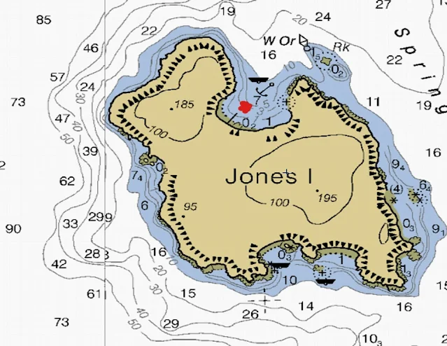
Jones Island is a wonderful place to take your family and enjoy boat camping. The islands unique proximity to the three major marinas and harbors in the San Juan's is a big plus, but even without these great nearby neighbors, Jones would still be your destination of choice.
A favorite starting point for kayaking is Deer Harbor, only 2 1/2 miles over usually calm water. Roche Harbor, a favorite resort and jump off point for those going to Canada is only 5 1/2 miles. Of course the San Juans largest city and port is Friday Harbor, at only 5 3/4 miles distant.
Marked below with a red dot are:
- Jones Island
- Roche Harbor
- Deer Harbor
All of Jones is a state park, the north cove is preferred by power boaters and sailors alike, inside you will find a protected bay with docks and anchor buoys, plus room to anchor if the buoys are in use.
The south cove is favored by kayaker's, there are several campgrounds and the island has running water, fire pits and picnic tables. On a sunny summer weekend it would not be unusual to find several large groups camping with many first timers. Off shore are a few anchor buoys. The cove is not protected from San Juan Channel traffic or swells.
The North Cove is absolutely wonderful, There is a brand new dock, anchor buoys, a steep gravel beach (good for dinghy's), and room to anchor. The cove is protected from all but the worst north winds (very infrequent) On shore are lots of tent sites, each with picnic table and fire rings. There is a nice mowed lawn area for games and grazing deer. Bathrooms and running water are clean, cool, clear and convenient.
The island has several hiking trails, rated, easy and moderate. From the trails are magnificent views of the surrounding islands, and waters. Bring your camera to Jones, you will want to preserve the memories to show your friends that aren't as fortunate as you.
James Island
James Island is a drive by island, meaning many boaters drive right by on their way to bigger name places such as Friday Harbor. Those that stop at James are rewarded with an entire island State Park to explore. James is a typical dog bone island with a narrow low isthmus separating two summits, and two coves. The east cove has a few anchor buoys, is open to Rosario Strait and the resulting swell and wave action, but the west cove is very protected, has a small four boat dock and room to anchor a lot of boats.
The satellite picture below shows how close James is to Thatcher Pass the main Thoroughfare for those heading to the San Juans from Anacortes.
- The distance from James to Cap Sante in Anacortes is 9 nautical miles
- James to Friday Harbor is 12 nm
- James to Rosario is 10 nm
- James to Cornet Bay at Deception Pass is 10 nm
At the head of the dock is a campground with bathrooms, picnic tables, fire pits and a shelter. An easy hiking trail follows the shoreline around the south end of the island affording grand views in all directions. A short way down the trail is a kayakers or self propelled vessels only campground, which is also accessed directly from the beach in the west cove. For more serious hiking you can follow the trail to the summit and get a great picture of your boat down below. Orcas sometimes swim just outside the kelp beds in Rosario Strait and may be spotted from your camp site, but only by those watching.
The North end of the island has no trails, but is easily bushwhacked following deer trails, however the heavy tree cover really limits photo ops.
James is a favorite place for day boaters over from Anacortes, but you will always be able to anchor. The beach is great for landing kayaks, dinghy's or your runabout, but be careful of a falling tide leaving you high and dry.
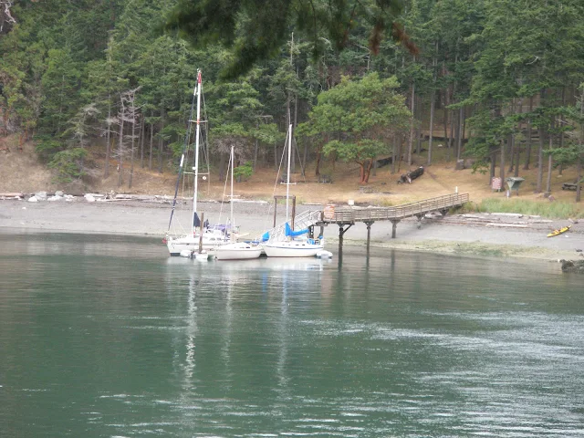 |
| James Island west cove |
Clark Island
Clark Island is overlooked by many cruisers rushing northward to Sucia. Not much more than a speed bump in Rosario Strait, Clark and almost twin Barnes Island are located between Lummi and Orcas Island. Although nearer to Orcas, Clark is more often visited by Lummi residents out for a lunch spot, day trip, or an easy overnight-er. Clark is only a few hundred feet wide where the campground is situated and barely above storm waves, the east side has lots of anchor buoys but is open to the wrath of Rosario Strait. The west side also has anchor buoys and neighboring but Private Barnes Island tends to somewhat protect anchored boats. Both sides of the Island are subject to the ever changing north south tidal currents so a loose dinghy will be swept away in a hurry.
I don't paint undeserved glossy images of parks, conversely I must clearly warn boaters that conditions in the middle of Rosario Strait change very fast. The tide and wind may create big waves making anchoring or using the buoy's at Clark a crap shoot. We stop at Clark when conditions permit, but I will not spend the night with my vessel anchored or tied to a buoy. Pulling a kayak clear of the water is fine. The anchoring and or buoy problem lies with exposure to Rosario Strait should the wind kick up sending huge waves pounding down on your boat causing it to pitch, roll and jerk its tether until something gives and everything inside is tossed upside down. If you happen to be camping on shore you will not be able to safely reach your boat by dinghy. If you are sleeping on board it will be miserable perhaps dangerous.
.My advice is to go to nearby Matia, Inati Bay or Eagle Harbor, where you can anchor and sleep in relative safety in any weather.
There is no other recognized anchorage in the San Juan's that I am compelled to warn cruisers about, but what would anyone expect, Clark Island is unprotected in the middle of Rosario Strait. Sticking anchor buoys out there does not make it safe or immune to weather.
Distances to where your going affect when you get there:
- Squalicum Harbor (Bellingham) to Clark is 16 nm
- Clark to Sucia is 7 nm
- Clark to Blakelys for ice cream and fuel is 8 nm
- Clark to Cap Sante (Anacortes) is 15 - 17 nm depending on route
 |
| Clark Island State Park Overview |
The little hook cove on the east side extends under water to snag boaters that don't pay attention to their charts or correctly interpret surface features. The littlest of the Sisters may surprise skippers thinking the Nav. aid is further south.
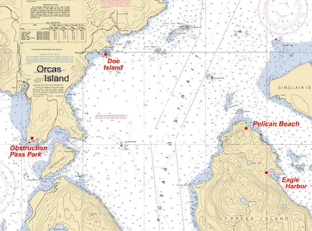
Doe Island Pelican Beach Obstruction Pass Eagle Harbor
Doe Island
Doe Island is a cute little park, sitting so close to Orcas Island it is easily missed even if your looking for it. Sitting just a few hundred feet off the east side of Orcas and just two miles or so north of Obstruction Pass, it's a side trip you should not miss. Stop there as a lunch stop or overnight-er. On shore are a few campsites and an old fashioned pit toilet, plus a few picnic tables. The circular shoreline trail may be walked in under ten minutes, maybe less than five if you speed walk.
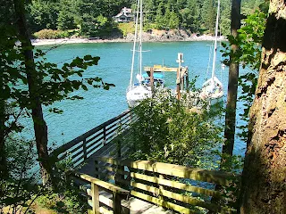 |
| Doe Island float |
Obstruction Pass Park
Obstruction Pass Park is somewhat unique in the fact that it is accessible by land or water. It is tucked away at the south east corner of Orcas Island at the end of a short half mile or so trail. The small campground is open to boaters, hikers alike. A single buoy is in the small bay plus room to anchor. The beach is dinghy friendly however being open to the pass and resulting traffic makes for lots of wake action. There are trails to hike and great views, bring your camera and lunch.
Pelican Beach, Eagle Harbor, Cypress Head
A destination for kaykers and cruisers alike, Pelican Beach is on the north east end of Cypress Island. Being a DNR park there are no fees. Six anchors buoys pretty much take up the entire open water anchorage, but you can squeeze in more boats in a pinch. The beach has lots of skipping quality flat stones is steep enough for easy dinghy landing in all tides. On shore are campsites, fire rings and the usual composting toilets. Throw in some of the best hiking trails around and its no wonder Pelican beach is rated highly by everyone that visits.
Just a stones throw south of Pelican Beach is Eagle Harbor where cruisers will find 16 anchor buoys, and a somewhat protected bay, but a poor place to land dinghy's due to thin water a long way out. You can land dinghy's farther out but then its a long walk to the bathroom if that's where your headed. For access to the trail system Eagle Harbor is a fine place to tie up, and you should plan one or more days hiking, as the trails are quite substantial. We like campfires so we always go to Pelican beach as first choice with Eagle Harbor or Cypress Head as a back up.
Further south of Eagle Harbor another mile or so is Cypress Head Campground with three anchor balls in a semi protected bay a handful of campsites on the bluff and a great dinghy friendly beach for campfires and access to bathrooms and the trail system.
Sucia, Matia, and Patos
- Bellingham is 20 nm
- Anacortes is 22 nm
- Roche Harbor is 16 nm
- West Beach resort for food and gas on Orcas Island is 7 nm
Matia Island
For peace and solitude, you can't go wrong on Matia. Matia is a very special place, but for most it is simply a drive by island on their way to extremely popular Sucia. I have said it before, if you must be stuck somewhere for any reason, Matia is tops. The easy trail system treats you to a true virgin rain forest setting, opening up to the semi arid rocky headlands the San Juans are known for. Carved into the east end of the island is a deep narrow cove for anchoring where you will be in your own world. The west end cove is much smaller but boasts a four boat float, anchor buoys and shore side camping. (no fires are allowed on Matia) The beach at Rolfe Cove is suitable for landing at all tides and is a favorite for kaykers.
 |
| Matia Island |
Patos
Patos has all the amenities you have come to expect from Washington's great marine park system, plus a lighthouse. The light was automated years ago but you can hike the short walk out there and take a look around. The bay formed between Little Patos and Patos is where you will anchor, there is no float so bring your dinghy if your going ashore to camp or explore. It's very tempting to run the narrow passage separating the two islands, but with a deep draft and any current, you may regret venturing down that path, besides when you go around you get a great photo op of the lighthouse.
 |
| Patos Lighthouse |
Sucia
Lastly Sucia, the most popular island of this little three island spree.
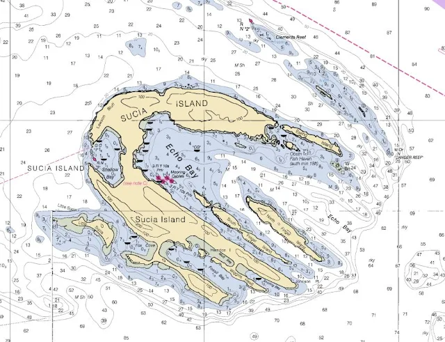
Take a look at the chart below, to see just how many inlets offer exploration possibilities.
I can't begin to fully list Sucia's attributes, so I wont try. You may want to know that Echo Bay is huge and hundreds of boats anchor there in the summer, plus they have buoys and a linear tie up system. The beach at Echo bay is easy to come ashore. Shallow bay is known for fantastic sunsets, and swells that some don't like when they are trying to sleep. The beach at Shallow Bay is not exactly dinghy friendly except at high tide. Fox cove is subject to currents . Fossil Bay is has some docks but you may find someone beat you there. The campground on shore boasts 60 campsites, picnic shelters, drinking water. Trails connect everything to everywhere on Sucia, bring your hiking shoes and plan more than one day to see it all. Next use you dinghy or kayak to explore the shore.
 |
| Fossil Bay (mud flats) |
 |
| Echo Bay |
 |
| Linear tie up at Echo Bay |
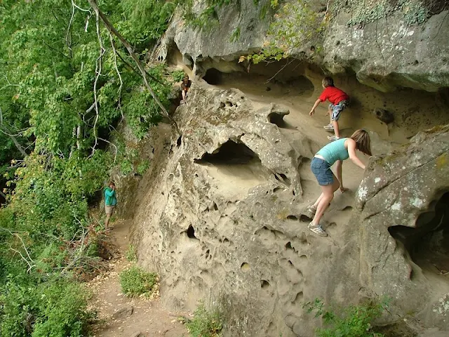 |
| China Caves at Shallow Bay |
Stuart Island Prevost Harbor Reid Harbor
Stuart Island for many is about as far as they go when coming to the San Juans.
Those cruising further north or west will be entering Canada making Stuart a good jumping off point for a visit to the Gulf Islands or Vancouver Island.
Flanked on the west by Haro Strait and, and the north by Boundary Pass visitors should expect heavy currents and commercial traffic, however once in the protected bays of Prevost and Reid Harbors you will find yourselves totally immersed in another world. The short distance to Roche Harbor makes Stuart especially attractive to human powered craft, with careful planning to utilize currents a boat can literally drift back and forth over the four mile distance.
- Stuart to Roche 4 nm
- Stuart to Friday Harbor 12 nm
- Stuart to Bellingham 33 nm
- Stuart to Sydney BC 10 nm
Stuart Island is mostly private, the Parks are located on the northwest tip, where the lighthouse is and a campground on the isthmus between Prevost and Reid harbors. There are anchor buoys in both harbors and a dock for over night visits on both sides of the isthmus. The two docks are straight across from one another and even though you can't see across, it only takes one minute to walk the short distance between them. Both harbors have docks and tie up buoys plus lots of anchor room.
Stuart Island is arguably the northwest corner of the United States, and to reinforce the geographic feeling you may want to check out the plaque by the light house marking the location. The boundary as noted is 2,316.5 meters off shore of marker.
Whether you decide to visit Reid or Prevost, you should also be planning to circle the island or at least run out to Turn point and back. Experiencing the forces of nature as the current sweeps by Turn Point is awe inspiring, even heart stopping in an under powered sailboat. Of course you could check your tides and go during slack water.
Odlin County Park
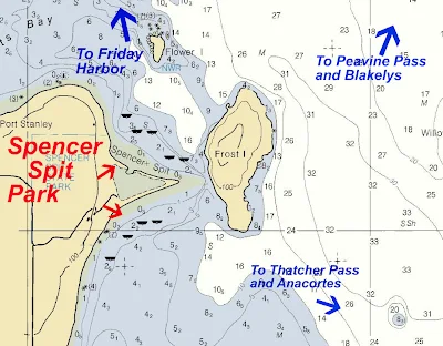
There are a few county parks and they are easily overlooked. Odlin on Lopez, is very close to Friday Harbor right on Upright Channel. A little dip in the side of Lopez Island creates an exposed bay with a nice beach. Olin has four anchor buoys with lots of open room. There is a day use only dock, but you can anchor very close and use as a dinghy dock, the bathrooms are a short walk. Since Odlin is accessible by car the campground will be busy
- distance from Odlin to Friday Harbor 5 nm
- Odlin to Orcas Landing 3.5 nm
 |
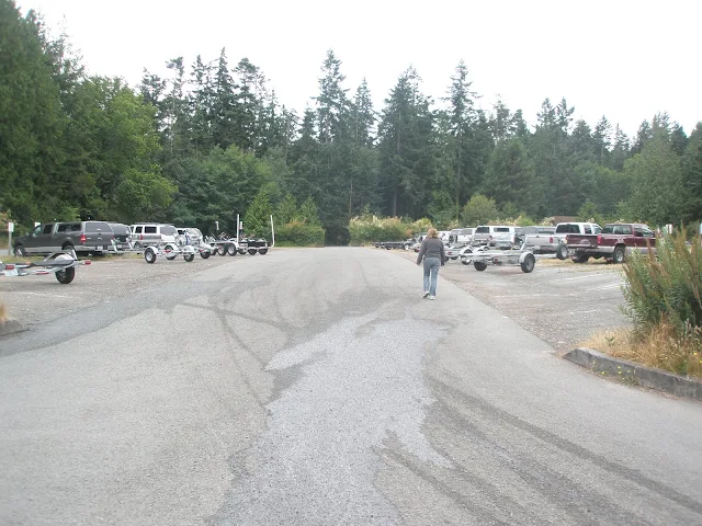
Odlin and Spencer Spit parks on Lopez IslandWashington Park (Anacortes)While technically not part of the San Juans, several parks need mentioning and Washington Park is one. Washington Park is a city of Anacortes park with an on site ranger. Located just past the Ferry terminal on Geumes Channel, it is the closest you can get to Thatcher Pass from the mainland. The park has a forested campground and a two lane boat ramp with float. Some people will set up camp and then take their boat for day trips into the San Juans returning each night to home sweet home. Another option would be to launch your boat and leave your trailer and car in the parking lot while your in the San Juans. The parking fee is about $8 a night and you pay at the unmanned kiosk. This is a popular fishing launch site and the parking may be full on weekends, I would suggest arriving after the day people have left or a weekday, plus have an alternate plan for parking. You are not allowed to overnight at the float and anchoring out while quite doable, will be uncomfortable due to to waves and swells from Rosario Strait.
Washington Park in Anacortes
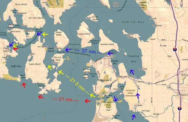
The distance to Friday Harbor is 15.5 nm, to Rosario 12 nm. With a ski boat all of the San Juans will be within easy day trip range.
Washington Park trailer lot is limited and there's no overflow facility
Washington Park launch ramp
Deception Pass State ParkDeception Pass on Cornet Bay is a worthy destination for any adventurous boater, but it is also an excellent starting point for those going to the San Juan's, Victoria, or the Gulf Islands. Like Washington Park you may camp in the campground and use the ramp to launch your day trips or simply park your rig for a week or more while you explore. For those coming up (by boat) from the Seattle or Olympia area, Deception Pass Park is an excellent stop over location to spend the night or just waiting a tide change. You will not need to worry about parking, anchoring or using the launch ramp regardless of time of day when you arrive. Swift currents, and fog present some timing problems and you should not be planning a trip without also planning to go through during slack water, at high or low tide. Of course the faster and bigger your boat, the less a problem the pass poses. Fog is another issue, and it seems to hang around quite a bit. If your uncomfortable, or not equipped to deal with the fog you need to use Swinomish Channel as a back up plan. (or primary plan) The boat ramp at Deception Pass Park is four lanes with floats, the ramps are in good shape and extend far enough for all tide launching and retrieving. The parking lot is huge, you will never need to worry about not having a place to park. Next to the ramp is a large dock you may overnight at, but your are supposed to limit your stay to three nights. Off shore is lots of good anchoring, and of course anchoring is free. On shore are typical state park bathrooms with showers. A very short two minute walk brings you to a well stocked store.
The satellite pic below shows just how close the park docks are to Deception Pass (one mile)
Deception Pass Park and Cornet Bay
Here's an easy fun afternoon hike; take your dinghy across the shallows of Cornet Bay to the steep rocky beach below the south summit, (straight across from Ben Ure Island) drag the dinghy up and tie it above high tide. Now the only hard part, bushwhack up hill about 20 feet until you come to the shoreline trail. Follow the trails to the summit for great views in all directions. (bring your field glasses and camera) Next hike the trails to the bridge for more breathtaking scenery, and if you want to make a day of it, hike down to North Beach or Cranberry Lake. Click below for article: Saddle Bag Island State ParkHere is another non San Juan Island that you will appreciate knowing about one day if your caught somewhere between Anacortes and Bellingham with no where to drop your hook and its getting dark. We learned our appreciation on our way from the Sucia area to Cornet Bay Via Swinomish channel; after stopping by Inati Bay on Lummi Island for a late lunch and then insisting on not using our auxiliary while tacking against the current in Bellingham Bay, we found ourselves hopelessly behind schedule. Our original plan was to make the entire distance to Deception Pass Park that day, or at least to the public dock at La Conner, but as the sun set we began discussing our options. One option was to head for Pelican Beach or Eagle Harbor, but that was a little out of our way, another was to drop anchor near any nearby shoreline, but we wanted the use of park bathrooms since the boat was not all that private. Saddle Bag Island to the rescue, we fired up the iron jenny and in thirty minutes dropped anchor in the little cove next to two other sailboats. Sometime during the night two more arrived and one left very early. During our last visit to Saddle Bag, while ashore around the campfire our fresh water galley switch failed, and turned the pump on. After pumping the tank dry the pump promptly melted, leaving us with only two quarts of water, a burnt smell and a $65 repair job.
Sunset on calm waters at Saddle Bag
By now you should know there is no garbage service anywhere
Saddle Bag is actually a pretty small island, the easy walking trail along the shoreline may be hiked in less than thirty minutes. The cove for anchoring is small and at low tide may have room for only a few boats, but not to worry, simply anchor further out. The only reason to be in the cove is for wave and swell protection and the water is more often than not, flat and glassy. Except for the occasional passing boat you should sleep like a baby On shore are fire rings, pit toilets and a small campground tucked away in the woods. The steep gravel beach is very good for dinghy landing at all tides.
As you can see Saddle Bag Island is close to Anacortes and very
convenient for boaters using Swinomish Channel.
Distance from Saddle Bag to:
Sidney Spit Park in CanadaSidney Spit, also not a San Juan Island needs to be in your arsenal of Islands and parks.
There are many others ports of entry, but not in this area. Canada |















No comments:
Post a Comment
The comment box was recently restored after being misplaced for a few years. Feel free to offer comments. Use the e-mail box to ask questions.