Obstruction Pass Blakely's Deer Harbor Roche Harbor
Friday Harbor Jackson Beach Hunter Bay Prevost Harbor
West Sound English Camp Orcas Landing Olga
Washington Park La Conner Eastsound Odlin Park
Set sail and go beyond the familiar. While most cruisers flock to the scenic marine state parks—complete with floats, campgrounds, and comforts—it’s worth venturing a little farther. These 16 public access docks give you a different view of the San Juan Islands, letting you connect to island life, explore towns, and stretch your legs off the water.
When visiting the San Juan's many of us head for the great marine state parks, and for good reason, that's where the floats, campgrounds, and amenities that vacationers desire are located.
However, if you want to get off the boat and see something other than campers and boat people you have two choices. #1 dinghy ashore somewhere or #2 find a public dock and head out. This list and description of San Juan area docks excludes the state parks because most marine state parks are landlocked or waterlocked leaving visitors with no opportunity to explore beyond the park.
Sixteen public docks organized and listed in no particular order.
#2 Blakely's is a conveniently located fuel dock about halfway between everywhere we go in the San Juan's. They are just inside Peavine Pass on Blake Island.
On shore is a small store and deli bar famous for ice cream cones to savor on the lush waterfront lawns. Grazing deer share the lawn so watch your step. The dock is rather long with plenty of room on both sides to tie up big and little yachts and still not interfere with those getting fuel. They offer overnight marina slips in a very protected tiny cove. The island and roads are private so boaters may not leave the resort property.
#3 Deer Harbor, on the west end of Orcas Island at the end of the road is diminutive Deer Harbor
community and marina.
You may purchase fuel and snacks, get ice and rent a slip. The county dock is actually the same dock as the fuel float. Simply tie up out of the way just past the fuel dispenser. The county section is painted yellow and accommodates several runabouts or one large yacht. This is an excellent jump off point for kayakers heading for Jones Island or dropping off people catching the San Juan Transit mini bus. The bay out front is calm and rogue wakes are few, anchoring room is abundant, restrooms, showers and laundry are on wharf.
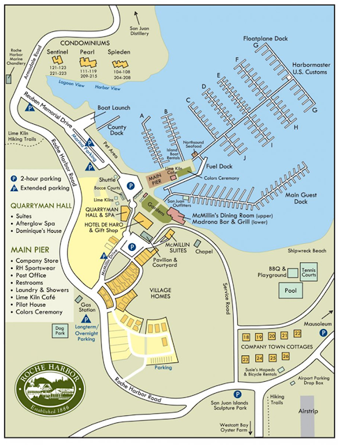
#4 Roche Harbor, is on the northeast end of San Juan Island and is a world class marina and resort.
They allow short term free ties ups for shopping, loading and unloading. San Juan Transit regularly stops as well as Kenmore Airline in case your guests arrive in true jet set fashion. Anchoring in the huge protected bay is easy and they have multiple large dinghy dock facilities.
 |
| Thanks to Roche Harbor Resort for this fine facilities map |
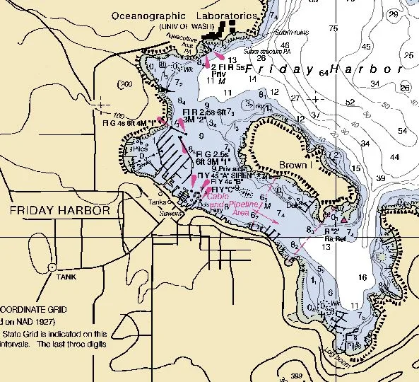
#5 Friday Harbor, is the largest city in the San Juans. Like Roche Harbor they offer short term free tie ups
while in town shopping.
They are next door to the ferry terminal, as such, rendezvousing with visitors coming by ferry is not to be overlooked in making cruise plans. Upon arrival, simply tie up at breakwater "A" or request a slip if you need something less exposed. Tip: Free anchoring is readily available in a medium sized cove immediately west of the marina. It is then a short dinghy ride to the dinghy dock under the main gangway. There is also a four boat short term float directly in front of the marina office just past the fuel float.
 |
| There is no launching ramp at the marina but at the far east end of the harbor are private yards with ramps. |
#6 Jackson Beach, is south of Friday Harbor or better described as, around the point past Turn Island.
Jackson Beach is a Port of Friday Harbor managed day use park and boat ramp with a float. This would be a good spot to meet friends, launch a car topper or runabout. Like all public docks, tie ups are short term and this one is part of a ramp facility so you are competing for space. Anchoring in the smallish inlet will protect you from the worst of Griffin Bay and the restrooms are just a dinghy ride away. Tip: Jackson Beach itself is loaded with storm tossed driftwood begging to be searched.
#7 Hunter Bay, is on Lopez island at the south end of
Lopez Sound.
This dock like most county docks, is not used much by cruisers and is not very big but there is a designated dinghy area and a loading zone. Fifty feet away is a hard surface launching ramp. Consider Hunter Bay as a place to meet others coming by car or bicycle. Anchoring close by is easy but may be rolly polly in a blow. There are no facilities or restrooms near by. Southend Market is about two miles by foot, up and over a significant hill. The Hunter Bay dock is hard to spot from offshore, it is located on the southeast side of the bay on the point of land separating Mud Bay and Hunter Bay.
#8 Prevost Harbor on Stuart Island has a don't-miss dock. The county dock is at the top of the harbor, very close to where you enter.
This is not the same as the two-state park docks. Since Stuart Island is not served by ferries, rendezvousing with car travelers probably won't happen but if you want to walk out to the old Turn Point Lighthouse museum (yes you do) you will find that starting at the county dock will save you about half of the two and a half mile walk. Tip: If you plan from the get-go to anchor fifty feet away and then dinghy over to the dock you will not be disappointed when there is no room at the dock for your yacht.
 |
| The dinghy float is down the plank |
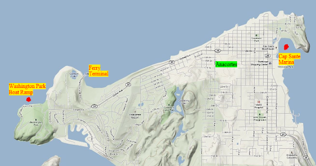
#9 Washington Park, is an Anacortes city
park and campground.
The dock is primarily for boat launching and retrieval but extends far enough that one boat may tie up at the far end without interfering very much with ramp activities. Being on the mainland, plus having a campground and long-term parking make Washington Park very useful when thinking and making outside-the-box plans. Washington Park is the closest point to the San Juan's for picking up and dropping off passengers. Tip: Have your visitors on bicycles come over on the ferry but park their cars at Washington Park to save money and make their return by boat convenient.
 |
| It's an easy bike ride less than a mile to or from the ferry. |
 |
| Washington Park boat ramp on Guemes Channel |
#10 La Conner: This artsy craftsy city on Swinomish Channel boasts three public docks on their seawall right downtown.
The recently completed boardwalk running the length of the waterfront is worthy of a visit by itself. Unlike county docks, La Conner welcomes over-nighters and makes modest payment easy with kiosks at each location. Tip: La Conner is worthy of making it your primary destination but don't pass through Swinomish Channel without stopping for at least a short walk around town. The fully stocked grocery, is about two to three blocks at most.
 |
| Swinomish Channel via La Conner is a handy alternative to Deception Pass. When you see Rainbow bridge, you know you are there. |
 |
| The new La Conner boardwalk is a hit |
#11 Eastsound, back in the islands. Eastsound the city is on Orcas Island at the top of East Sound the waterway.
The county dock is a short one-block walk into the center of town. The float holds two or three smaller boats but can easily be overwhelmed by one large yacht. Dinghies crowd the inside and need to be jostled around when more than six or so are tied up. Anchoring nearby is simple but heed the sign that says to stay out of the eelgrass. Tip: Be forewarned that if you plan on overnight anchoring, wind waves can get messy due to the large fetch starting all the way down in Lopez Sound. Nearby Judd Bay is a good alternative for anchoring. In all of the San Juan cruising area, Eastsound is the shortest walking distance to a major grocery store. I don't count the very short distance to the convenient dock located at Roche harbor store because it is not all that big and has slightly higher prices.
 |
| Judd Bay is in the far far background and is mostly protected from nighttime wind waves |
#12 Odlin County park, is on the northwest end of Lopez Island facing
Upright Channel.
The park's location on a large bay or rather indent in the shoreline suggests protection from passing ferry and boat wakes but don't be fooled. Anchoring or hooking onto any of the four park buoys may result in a miserable rolly stay including possible anchor dragging. On the bright side, the county maintains an excellent dock for two-hour tie-ups and dinghy landings. The popular waterfront campground is first rate and it is only a twenty-minute bike ride into Lopez Village. Tip: Use Odlin Park as a very convenient pick up drop off and rendezvous location when planning trips with car and bicycle campers around the islands.
 |
| If you spend anytime anchored or tied to the dock at Odlin be prepared for wakes. |
#13 West Sound County Dock is located at the top of
West Sound on Orcas Island.
The little used dock is on the road to Deer Harbor where it intersects with the road to Eastsound. There are no stores or restaurants left so few cruisers come up this way except those going to the nearby West Sound Marina fuel dock. If you are inclined to hike up Turtleback Mountain, this will be your best access. The dock is only 1.2 miles from the trailhead on Wild Rose Ln.
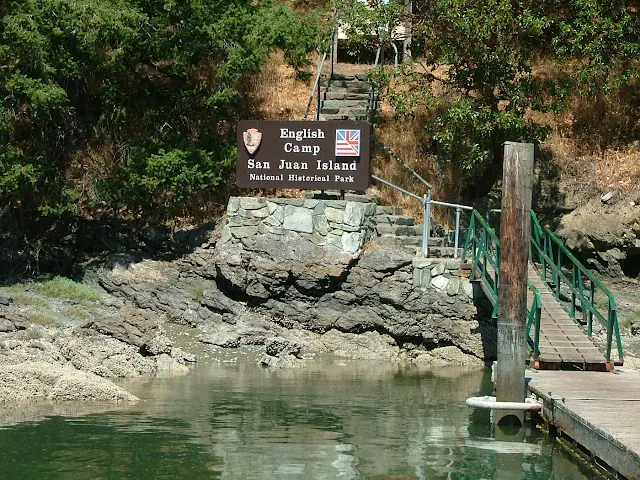
#14 English Camp dinghy dock in Garrison Bay on the northwest end of San Juan Island is neither a county
or state park dock.
It is a national historic site. The public float is included on this list because it provides easy access for boats anchored in tranquil Garrison Bay to get to West Valley road and for hiking up Mount Young, aka. Young's Peak, aka. Young Hill.
#15 Orcas Landing is, you guessed it, right next to the ferry terminal on
Orcas Island.
The Orcas Island ferry terminal is on the south side of the island facing Harney Channel and Blind Bay. This medium length float takes the full brunt of wakes from passing trawler yachts so tying on the inside is an absolute must if your hull isn't up to the task. Onshore are gift shops, coffee spots and a restaurant or two depending on the season. Across the street are public restrooms. Acres of parking lots and ferry waiting lanes cover the hillside. Other than Friday Harbor this is the only place a boater and ferry traveler can meet up, or a cruiser can drop off a passenger catching a ferry for home or another island. Tip: Don't drive behind a parked ferry.
#16 Olga is on Orcas Island just around the corner from Obstruction Pass on the southeast end at the beginning of East Sound.
The local community built and maintains the 4-6 boat float for public use. There is no water, beach access or restrooms. Onshore a three block walk up hill is a café/gallery. Three nights are allowed and the bay is quite a ways from the active East Sound traffic making this an excellent spot to wile away the day, relax or meet friends coming by vehicle.
 |
| At the end of the long skinny wharf is the small four boat Olga float, don't expect it to be empty like today. |
Other docks? Yes of course, scattered around the islands are some private resorts with docks. Rosario Resort would be one, Fisherman Bay has two.
The docks on this list are primarily public or have the welcome mat out for short term visitors. Most of those listed provide access to the roads and highways allowing shoreside excursions. Almost all of the State Parks have floats but few have highway access. All the state parks are listed on the marine parks and maps lists.
Tip: Locate and mark these docks on your charts or write them in your ships log. It's nice to know where you are welcome.


No comments:
Post a Comment
The comment box was recently restored after being misplaced for a few years. Feel free to offer comments. Use the e-mail box to ask questions.