Throughout our cruising area are literally thousands of places one can poke a boat into, drop the hook, and go ashore.
- WRONG. Most places, including beaches, are private property and you will be trespassing on shore. We as boaters are limited to parks, preserves, resorts, etc.
The problem is that our charts do not show all there is to know.
Lummi Island Campground
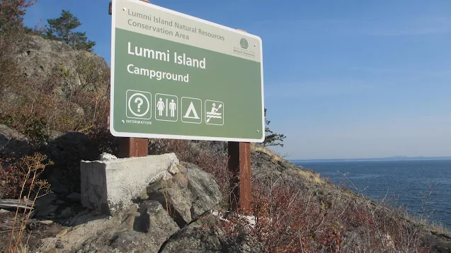
This is a small five site waterfront campground within the 650 plus acre Lummi Island Conservation Area. It is a very hard to find place, the picture posted and my description will be your best resource for finding your way.
For those of you new to the area, Lummi Island is that big land mass blocking your way to just about everywhere when you put in at Squalicum Harbor in Bellingham.
The campground is near the south end of Lummi on the east side. Your NOAA based chart will show Smugglers Cove, Inati Bay, Reil Harbor in that order, just south of the small Reil inlet is an even smaller cove. There is no name but your chart should have a little boat symbol which is the icon for a mooring area but don't get your hopes up, this is a dinky little cove that will require a stern tie or anchor to keep you from swinging onto the rocks. You can pull off a 2 to 1 rode lunch stop if your lucky. It is unlikely two boats can coexist unless they raft.
By now you should have figured out this place is perfect for kayakers, but you can squeeze in. The dinghy beach is gravel. Use the campfire rings and composter outhouse. There is even a loop trail to hike.
Look for this sign as you coast along the shore, it is high up on the bluff on the right side of the cove facing somewhat southward.
 |
| The pic looks big but from the water the sign is small and easy to miss. |
 |
| If overnighting or spending any time here you will want to tie to shore or drop a stern anchor to keep you from swinging onto rocks. |

