Fun Observations and Frivolous Knowledge for
All Boaters new to the San Juan's (repost)
#1 Hugely fluctuating water levels (tides)
The San Juans have high and low tides every day, some very high, some very low. This means you will need to be prepared to deal with going ashore at locations lacking floats. The easiest solution is to bring a dinghy; if you don't have a dinghy I suggest you buy a cheap inflatable boat or 2 person kayak for around $75. Once in the San Juans most people simply tow the dinghy everywhere they go, or deflate and stow it away. Those of you going in a ski boat or skiff may be thinking you can beach your boat, which will work, but only for a few minutes. On a falling tide in ten minutes your boat may be high and dry, unless you can carry it, your stuck until the tide comes back up. On a rising tide your boat will float away while you're on shore. Since your going to anchor in six feet of water at low tide you will need one hundred feet or more of anchor rode to accommodate a ten foot plus increase at high tide. Smart boaters bring two anchors and rode and a dinghy they can carry up above high tide.
#2 Strong Swirling Currents (in places)
San Juan currents are notorious, and the root of many stories. For fast planing boats you can pretty much ignore adverse current; however slower boats live and die by planning passages to get an assist from the current. A typical sailboat may putt along at 4.5 mph, against a 2.5 mph current their real speed over ground is 2 mph. Going with the same current their sog is 7 mph. So a ten mile passage takes 5 hours the dumb way or 1 hour 25 minutes the smart way. There are many prediction and forecast books and charts available and online. While you don't need a publication, I recommend that you buy something and keep it with you. I would also go online and print out a tide schedule for the time and area you expect to cruise. CLICK BELOW for Rosario Strait at Guemes Channel
NOAA tide forecasts
NOAA tide forecasts
In a nut shell, here's a simple rule of thumb to follow. On a incoming or rising tide, the water in most straits and passes flows "north" while during a falling tide the water reverses and flows "south." When the current hits an island straight on, the water will split and flow around the island usually at a slightly higher speed creating eddies at headlands and the tips of the island.
San Juan and Gulf Islands Current Atlas
San Juan and Gulf Islands Current Atlas
#3 Weather could be fog (pea soup is the term)
You can get lost in the dark, in the fog, or just plain lost on a sunny day. You need to bring with you a chart, and you would be smart to protect it from getting wet or torn up. I sandwich mine between two clear acrylic sheets held together with velcro.
Some will say the chart needs to be new and of the highest resolution, which may be true for ship captains and other navigators. What were talking about here is not getting lost, even a google print out may do the trick. If you are going to boat in the fog you must have a compass, and GPS, a portable handheld GPS will do fine and some new phones may do the trick too. (in thick fog you will go in circles and be totally disoriented without a compass) A gps will not replace a compass in rough water and fog, a gps is much too slow reacting when you are getting spun from broadsides or quartering waves (broaching) you need both. Many times in the San Juans visibility may be down to 3 or 4 miles and you think you can sneak across some open water to the next island, and you probably can, but if the fog thickens to pea soup you will be glad you have your compass and GPS. BTW, fast boats can't always go fast when waves and swells stack up. And only very dumb skippers go fast when they can't see.
 |
| See the ferry approaching the anchored sailboat? |
#4 Wind or lack of wind (sorry sailors)
OK, here's some bad news for sailors. The San Juans are not known for great sailing winds in July and August. Out in the straits (Haro, Rosario, Georgia, Juan De Fuca)
you may get some decent sailing, but inside the islands, don't bet on it.
 |
| Sailing in April rain with reefed main |
#5 Crowd control (no worries)
Most likely you won't have any problems with crowds except on the 4th of July and Labor Day. The good side is that you will always find a place to anchor, even on holidays, the dinghy ride may just be a little longer for some. Most marinas take reservations and you may as well take them up on it, but you don't need to. I suggest you slow down a little and enjoy the freedom of not planning ahead, take one day at a time and see where you go. Lastly, because this area is so close to Bellingham and Anacortes many boaters are day boaters. At the end of the day they head for home, leaving some resorts and parks half empty, especially on weekend Sunday nights. Monday or Tuesday are good days to begin your outing if you want to be alone.
 |
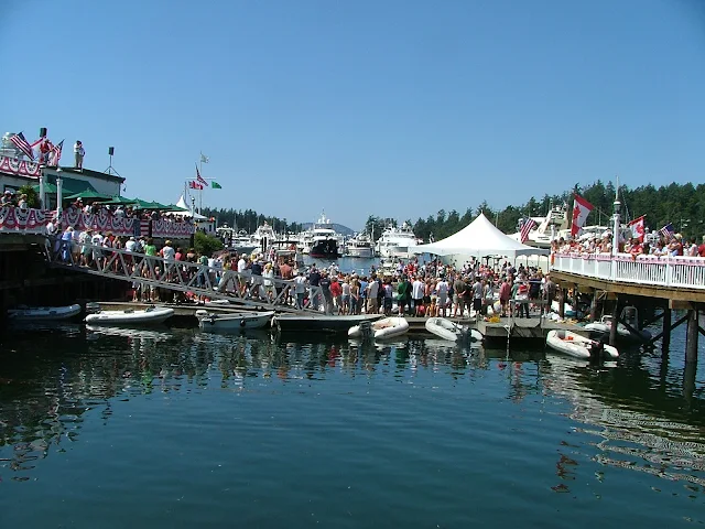
| Fourth of July celebration in the San Juan Islands at Roche Harbor Resort |
Roche Harbor 4th of July balloon contest for kids in dinghys
yes, there was room for more, lots more
Expenses
DNR buoys are free (Cypress Island) State Park buoys are $10, many park floats are 50 cents a foot, Marinas charge between 75 cents and $2 a foot. Gasoline is a little more expensive than on land, but not much more. Food, groceries, ice are just a little more than the mainland but very fair priced overall.
How many days to plan
Plan a minimum of four days, but up to two weeks depending on what you like to do. (I like to sit on the dock at Jones Island and read my book between naps and walks, then I make a campfire in a empty tent site and cook Kielbasa followed by a glass of wine. Then retire to my boat for a good nights sleep. The next day, do it again)
Salt Water
Salt water drys sticky and does not suds up well with soap, you will get it all over you and your boat, count on it. After a week you will look forward to a shower. Your boat will be covered with salt crystals. Most marinas have little water and don't want you washing your boat.
Squalicum Harbor in Bellingham has boat and trailer fresh water wash down hoses in the parking lot. You should use them each time you dunk your trailer.
Provisions
For the most part you will want to provision before you leave on the boat. Anacortes and Bellingham have all the big stores and each has a West Marine store. All the resorts and towns have grocery stores, if you drive a fast boat, supply's may be only minutes away, putt putt's should work a store visit into your circuit. I say circuit because most cruisers will follow a circle of some sort trying to hit many stops. We find that ice needs renewing after four days, so a stop over at Friday Harbor, Deer Harbor, Roche Harbor, Blakelys, or Orcas landing fills the bill. All these places except Orcas, have gas and showers. Showers will cost a handful of quarters so be quick or be poor. Cold showers are free. Lopez Village has free showers but no dock so you will need a dinghy.how to dinghy to Lopez village
Garbage
All the parks are pack it in and pack it out, the marinas have dumpsters. If you are new to boat camping you will find garbage to be a pain because you are not used to storing everything in your boat. Little things like empty water bottles suddenly take space you don't have. You must give careful thought to what you are bringing, and the garbage it will generate. We don't use disposable bottles, minimize pop consumption, and try to have campfires to burn burnable trash. It is against the law to toss anything, (even a apple core) in the water.
Animals
Your dogs must be on a leash, period, everywhere. Raccoon's are on all islands and will climb right into your boat or kayak in the day time if you let them. Deer are all over too, but they shy away, except on Jones Island where you can hand feed them.
Otters live under most floats and docks, they will crawl all over your boat, get into things and make a mess. Otters also will mark their territory by pooing on your stuff, dock lines are a favorite.
Bathrooms
All the parks have nice composting toilets, (each island mentioned for overnight is a park) the rangers service all parks on a regular basis. You will be pleasantly surprised at how clean the facilities are.
Where to go:
Your destination is simply that, its the journey getting there and the experiences on the way that make a trip a wonderful vacation. Try the links below for some Island Park descriptions.
Emergency's
Bring your cell phone and charger, bring at least a portable handheld marine radio, bring basic first aid kit, call the Coast Guard, they can be there pretty fast, or arrange for vessel assist on your credit card, bring a friend with a similar boat, then you can help each other.


