Spring Street (main st) Friday Harbor |
Travel Guide, Itineraries, Maps, Charts, Parks and Camping Cruises. Places to go.
Things to do. Pictures, Reviews, Moorages, Marinas, Boat Ramps and Much More.
ATTENTION!
++++ ============================= All Posts Below
8/10/2023
Fifteen best lessor known destinations and hikes not to miss when cruising the San Juan Islands
2/29/2024
Taking your boat to the San Juan Islands - what you need to know.
This post covers just the bare basics needed for a San Juan Islands visit. Think of it as simple answers to some very important questions.
Just because it is on a trailer does not mean it is a good idea. |
#1 Where to begin this epic outing?
One of these four places may offer exactly what you need to get the boat wet. First, but not necessarily best, consider Cap Sante Boat Haven in Anacortes. Cap Sante offers light and heavy travel lift slings but no launching ramp. They also offer short or long-term pay trailer parking and an RV park. You definitely will want a reservation for slinging and mast stepping. You may be able to reserve a slip at the transient dock. The costs are not cheap.
The next place to consider is Squalicum Harbor in Bellingham. While travel lifts are available at the port, their multilane all-tide boat ramp, long-term parking, and abundant transient slips are what most boaters come for. If your destination is the northern San Juan islands or perhaps jumping over to Canada, this is by far the best place to begin and end your voyage. No reservations are needed, and they operate 24/7 with a self-pay kiosk.
Next, back in the Anacortes area are Washington Park and Deception Pass Park. Washington Park is a city-owned campground with a two-lane boat ramp and float and trailer parking. You don't need to stay at the campground, you can simply use the ramp and park for up to two weeks. Pay 24/7 at the pay station. Parking may be limited so avoid weekends if you can or have an alternate plan. Tip: Plan an outing staying in the campground, taking the boat into the San Juans for day trips. Of course, you will need reservations for camping. Lastly, just a few miles away is Deception Pass State Park. The launching ramp and transient docks are at Cornet Bay and are just a stone's throw from the famous Pass. The ramp is usable at all tide levels, has four lanes and floats and has abundant long term parking. Pay 24/7 at the Kiosk. Cornet Bay also boasts a marina, fuel and a convenience store. All four locations have nice restrooms with pay showers.
There are a few other options for launching such as boat yards and some inferior ramps but these are the ones recommended that have parking. all the ramps As an aside, taking your boat on a ferry expecting to launch from a ramp on one of the islands is not a well thought out plan.
#2 Before you get going you need to take a good hard look at your gear. Ill-prepared skippers not only risk ruining their cruise but they jeopardize the safety of everyone around them. On the flip side, well-prepared captains seem to always have great drama-free vacations. Speaking of gear, you need a way to get to shore from your anchored yacht. A cheap two-three-man inflatable will work, paddle boards work, but beaching your boat is not going to work well for you. basic gear needed
#3 Okay, you're all packed and on the highway but where will you spend the first night? Good question and the answer is all up to you and what you want. What I have learned, is that what works best for me is to stay at Cornet Bay or Squalicum Harbor on the boat. It is usually late and we are tired, simply getting on the water is enough for day one. Your plan may be different so here is a list of parks. parks, parks, parks , and here is a list of resorts and marinas waiting for your arrival. resorts and marinas
#4 You are well on your way now. I hope you brought some food and fuel, if not, don't worry, here is a list of places you can go to get all the stuff you forgot to bring. places with food and supplies
#5 If you are really going to the San Juans you will have dozens of new questions now that you are thinking about it. So try this link for more answers >> basic questions answered
#6 Lastly, along with planning where to go it really helps to know the distance between points. Use this handy mileage chart. water mileage chart Remember, currents and tide fluctuations are part of every passage.
#7 When to go. This is not a difficult choice, just go when you are able, but avoid winter weather. July and August weather attract more people but there is plenty of room. Holidays can get festive and tend to attract crowds but sometimes that is what makes it a great vacation.
8/18/2011
Dragging Anchor on the 4th of July Minutes Before the Fireworks at Roche Harbor Was a Near Disaster
You Don't Want to Miss Fourth of July at Roche Harbor This was going to be the best boat trip ever. We are headed to Roche Harbor in the San Juan’s where we will join in the fun celebrating with 1,000’s of boaters from all over the Northwest and beyond. And it really was a great trip, just not the one expected. Roche Harbor (yes, pronounced “Roach”) is a destination resort for boaters and non boaters alike, nestled on a fairly large protected bay on the northwest corner of San Juan Island in Washington State.
Our trip starts in Portland, OR where we live. But our boat, a 28 foot sailboat, is moored for the summer in Anacortes WA. Having done this 275 mile drive many times, we had developed a system and are not in a hurry, after all we are on vacation. We left Portland late in the morning, breezed through Seattle traffic and arrived at Cap Sante Marina in Anacortes ready for dinner. The first thing we do is make sure “Windsong” is still floating in our leased slip and that the batteries are fully charged. After checking out the boat and stowing all our "must have" gear and toys we head for one of the many restaurants we have become familiar with. When we first started exploring Anacortes some locals had recommended the bowling alley as the best place to get a good and sizable meal, and I can’t disagree, but we thankfully found that other places deserve our business as well, especially if some sort of ambience is on your menu. It usually takes all day on the road and a meal in a strange city before the kids start realizing we are off on another boat ride and start offering advice about what to stock up on for provisions. Don’t forget coke and chips and trail mix and cookies and hot dogs and everything else. So it’s decided once again, everyone will help with the shopping. After dinner we park in the parking lot at the top of the ramp leading to the boat, and we split up. I haul another load to the boat while the rest of my crew walks across the street to “Safeway.” Having a major grocery store nearby is a great benefit. By the time I get to the store they have filled a cart with a week’s worth of really wonderful great stuff. Where’s the fruit, wine, cheese and M&M’s I want to know. It’s getting dark as we haul our loot across the street and down the long floating walkway to the boat. It’s never boring at a moorage, there is always someone to talk to, some weird strange floating craft to look over, something in the water to check out. We finally get everything packed away, “Windsong” is sitting much lower in the water, the children have staked out their over lapping territories, the moorage has become quiet, and we can hear muted conversation drifting across the calm water. It’s time to open a bottle of wine and relax in the cockpit, “no I say” you can’t have a coke, as I pull out the cork.
Morning comes early for me. As I wake up I think once again of a quote I read that went, “All boats under fifty feet are designed for just two people” and I think to add “and only if the two people are a couple.” I slide the hatch open to see, not sunshine, but fog, which means grab a coat, everything is wet and cold. Hopefully this is the last time I walk up the ramp today. Inside the Safeway is a Starbucks, where I purchase two steaming cups off strong black coffee. I really, really, don’t like Starbucks coffee. A baker’s dozen donuts to go, and I’m back at the boat with breakfast. A quick final check of boat systems and I cast off, Linda is up, Jaiden and Kailey are still asleep; or at least they pretend to be asleep, the idling diesel motor is noisy, bangs, shakes and rattles everything within its reach. Windsong moves effortlessly through the still water leaving no wake, at 1450 rpm the motor is smooth and without vibration, time for coffee and donuts. Roche Harbor is about 26 miles, six or seven hours motoring, even longer, or not even possible if we sail. Today is the 3rd of July and we plan to spend the night at Jones Island Marine Park. Normally sailboat travel in the San Juan’s involves planning your trip around constantly changing tides and currents, which make a big difference in the time it takes to get somewhere and the fuel you use. But for us, this is the second day of our vacation and we’re heading out regardless of current. Almost immediately we are swept into the outgoing tidal current and are whisked along at twice our normal speed. Ah, good planning skipper. The fog is limiting our visibility as we cut across Rosario Strait heading for Thatcher Pass. We don’t have radar and I don’t want to be near any ferries so I take a somewhat northerly course. Of course now the current is pulling us sideways right into where I don’t want to be. More good planning skipper. We have a reliable GPS that will help keep us off the rocks. The fog is pea soup now, visibility is only a hundred feet or less. Just three or four times the length of the boat. We are essentially running blind. As we approach Thatcher Pass I maneuver very close to the invisible shore. Everything is white and I am dripping wet from condensing fog. What a great trip. We are constantly monitoring the depth sounder and GPS, staying in shallow water we work our way further into the pass. The boat is moving slow as we feel our way along. I’m glad the current is against us now or we would be pushed along faster than we could stop or turn should we need to. Our senses are acutely tuned to the situation at hand, I know the ferries can’t come this close to shore, my worry is other nuts like us groping blindly along. If we encounter a boat moving fast we will collide before we can take action. Suddenly the fog begins turning more white and bright, it is hurting our eyes. In a matter of a few feet we slip into a bright sunny day. Visibility is unlimited, we are a few hundred feet offshore. (too close)
The rest of the way to Jones Island is pretty routine. We pass by Friday Harbor, steer clear of several ferries, and lots of boats. All of Jones Island is a Washington State Park, and my favorite place to visit.
The cove is protected, the dock is long enough for six or so boats, and there’s plenty of room to anchor. On shore the deer are friendly and some will let you pet them. There are campsites and fire pits, running water, toilets, trails. Roche Harbor is just a short ways further, we will leave around noon tomorrow, I want to get there in time to claim a good spot to anchor, and then dinghy to shore to visit the sculpture garden. The flag ceremony will be at sundown, for several years I have wanted to be at the flag lowering and watch the color guard. I know they fire a cannon as part of the ceremony. We are in luck, a boat is pulling away from the dock as we enter the cove at Jones, Minutes later, “Windsong” ghosts up to the only spot available and we toss our lines to willing helpers on the dock. We are set for the night. Jaiden and Kailey head for some tide pools still exposed from low water.
Linda and I take off on the trail across the island, we see several deer in the woods. The campground on the other side of the island is used mostly by kayakers because it has no dock and the cove is not very big or protected. Sometimes we see groups huddled behind tarps trying to get out of the wind. We wonder if they know that they can paddle around to the other side where there is no wind at all and lots of great campsites. We pick a hand full of apples from the small orchard and walk back into the woods planning to feed the deer. The apples are not ripe, they are small and very hard. I’m not so sure they like them this early. As we walk back towards the cove we try to hand feed a deer but it shies away. I leave some cut up apple pieces on a log. The next day I see the apple pieces are still untouched, the raccoons must not be fond of tart fruit either. Sorry guys, All I have on the boat are M&M’s and chips. Jaiden and Kailey are busy on shore with some new friends, this is a good time to do some reading. Tonight we have a campfire in one of the empty campsites and then sleep comes easy for everyone, it has been really exhausting doing nothing all day. In the morning I want to sleep in but the desire for our own coffee gets me up and soon we have our drip coffee maker happily sitting on the burner. It seems to take forever for the 12 cups to drip into the pot. At home we have a timer and the coffee is ready when I get up. This camping is cruel. Finally cup in hand I walk down the dock, other boaters are up and about, some are leaving for parts unknown. Some boat campers are on shore in tents. The dock has a spot designated for dinghies, used by boaters that are anchored. Dinghy docks never have enough room so boaters just tie their dinghies as best they can. Windsong is tied up in a 30 minute parking/loading zone between the hours of 8:30 am to 3:30 pm. It’s getting close to 8:30 and one of my crew is nagging me to do something. Luckily the boat in front of us soon prepares to leave and as he pulls away from the dock I simply pull Windsong forward to the newly vacant space. “Happy?” I say to the crew. Now we can park for 14 days.
Today is the fourth of July, Roche Harbor is just a short distance from Jones Island. I’m sure that boats are already arriving at Roche by the hundreds, some will have reservations at the dock made a year in advance. The overnight fee is $1.50 per foot. Windsong would cost $45 per day but there’s not a chance in the world that space is available. Our plan is to anchor as close as possible so rowing the dinghy is not too hard or far. It’s time to go I decide, everyone that needs to go ashore better get going, we need to leave. Suddenly I’m in a rush, the anxiety of not knowing our accommodations at Roche has got me tensed up. This is not why I go boating. I’ve checked my current charts and tide predictions, but once again it doesn’t matter which way the water flows, were on a mission, a quest. Hurry up, lets go. We must get to Roche Harbor and stake out our place to watch the fireworks, then go ashore for the flag ceremony. Soon enough Windsong floats across the shallow short cut on the east side of Pearl Island and we get a full view of the bay at Roche. Wow, what a sight, boats are everywhere. There must be a billion dollars worth of RV’s floating around us. I spot some Ocean Alexander yachts that I think sell for a million. (Years later I find out $15-20 million is more like it)
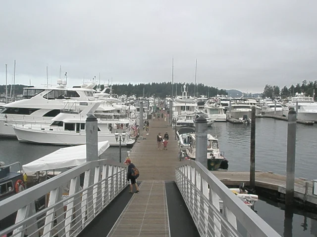
We see a motorized barge anchored with some warning buoys around it. That must be where the fireworks will be launched after dark tonight. We slowly motor around taking stock of what is before us. I see to the left of the massive rows of docks several lines of boats rafting. There is a raft of about fifteen power boats lashed tight together, several rafts of three or four sailboats. Power boats and sail boats aren’t rafting together, it’s almost as if they don’t like each other. Dinghies are going to and fro, some fast some slow, many are overloaded to the point of ridiculous At the end of one long raft is a gap about one hundred feet wide and then lots of individual boats anchored. It’s perfect for us. All the boats in this tight area are anchored fore and aft to keep them in line and from swinging into each other. We lower our plow anchor about seventy five feet in front of where we want to be and slowly back up in our spot paying out the anchor line as we go.
At the right point I cleat the line hard and keep powering back setting the anchor by forcing the plow point into the bottom. When Windsong shudders to a stop I give the throttle a little boost to make sure were dug in well. While I hold the boat in reverse keeping her in place, Kailey pushes off in the dinghy with a folding grapple anchor and a floating yellow line. I instruct her to paddle to shore and wedge the anchor between some large boulders. We now have secure lines out the front and out the back.
After turning off the motor it’s a simple matter to pull the boat forward with the anchor line until we are in line with all the other boats. And then taking up the slack at the rear to make sure we don’t move sideways. This is how all the boats in the line are anchored, there are so many yellow lines going to shore it would be impossible to paddle a dinghy behind the boats without losing your head. In front of the line of boats is a clear unobstructed passageway with a steady stream of dinghies and yachts moving back and forth from the resort. We have about fifty feet on each side of us to the next boats. I motion a hello gesture to one group and get a resounding “Having a great party, do you need a drink” response. The response from the guy in the stinkpot on the other side isn’t friendly, he acts like we invaded his space and thinks sailboats should be sunk. Kailey ties the dinghy to our swim platform and we are set for another night, or so I think.
On shore at Roche Harbor are restaurants, a well stocked grocery, half a dozen sidewalk booths selling local artist creations, snacks and ice cream. There are hiking trails, a swimming pool, and flower gardens that wedding groups use. A short hike up the hill takes you to the grass airplane landing strip and a forty acre sculpture garden. We all pile into the dinghy and paddle off. The dinghy dock at the main moorage is full so we head for the little dock by the swimming pool. On shore we are just in time to watch the blind dinghy race. I wish we would have been earlier to join in, it looks like a lot of fun. The “Blind Dinghy Race” has two people in each dinghy, the one paddling is blindfolded the other one yells directions. All the racers start at a open stretch of dock and paddle away when the start gun fires. They paddle under an overhead walkway lined with spectators. The racers try to avoid the pilings and then turn around and come back to the start dock. Oars are flying, people are screaming, "left, left no the other left, now right, right" dinghies are colliding. Someone eventually claims the prize. A little later in the afternoon is a children’s only, balloon capture. All the participants and their dinghies are in a small area surrounded by docks and cheering parents. At the start a large quantity of big balloons is dumped into the open water and the children try to collect as many as possible into their boats. The one with the most is the winner, but all the children receive prizes. Pandemonium ensues and the balloon capture quickly deteriorates into a free for all with several kids going over the side trying to get balloons. Even in July only the most hearty and fearless swim in the cold San Juan waters.
Eventually we stock up at the grocery store, buy some ice and head for the boat to have dinner. As daylight begins to slip away we are entertained by three Bald Eagles perched in the trees on shore behind our boats. The Eagles noiselessly glide down and snatch fish from the water and then with a few powerful wing beats are back in the trees. Repeatedly these majestic birds dodge dozens of taut yellow lines to grab a quick bite. Not once did I see an Eagle tangle with a line.
In about thirty minutes the Roche Harbor staff will be lowering the flags and firing the cannon. Several times in past years circumstances or poor planning have caused me to miss the ceremony, finally the stars have aligned for me, and on the fourth of July at that. This is a great trip. The kids will stay on the boat while Linda and I paddle ashore, I’m in the cockpit anxiously waiting to leave. When I look over at the unfriendly boat I sense that it looks different, it is about thirty five feet long and fifteen feet tall at the flying bridge, I’m sure it gives the owner a sense of power looking down on our puny boat. The wind has been steadily increasing for the past hour and I suspect this boat is catching the wind and straining at the anchor lines which would move him a little closer to us. I ask Linda, ”do you think that boat is getting closer?” As I’m watching I become sure it is half the distance it was. Now I know for sure, we have a problem, the boat is only ten feet away. There is nothing I can do. The other boats anchor has broken out and it is dragging into us, the last ten feet closes rapidly and he is against us. I hold him off long enough to grab a fender and place it between us saving us both from damage. I’m banging on his hull with my fist trying to get their attention, but Linda tells me she saw them all leave earlier.
This is not good. Our ground tackle can’t hold a twenty thousand plus pound boat caught sideways in a rising wind. His surface area alone is probably greater than all our sails. I know our 5/8” nylon anchor line will hold, but our 35 pound plow could break out at any second. Then I glance at our braided yellow stern line, oh boy, it is stretched to the breaking point. It is so tight it is only half the diameter it’s supposed to be. The line was never intended to take this kind of load. I had bought an inexpensive floating line for dinghy work, not this. The wind is picking up, if our line parts or anchor breaks free were going to have two boats crashing into the line of rafted boats on the other side of us. I yell over to the rafting good time party people and tell them "I have a serious problem, soon to become their problem too." They immediately jump into a couple inflatable dinghies with outboards and begin pushing against the wayward captainless yacht relieving the tension on Windsong. Kailey gets in our dinghy while I untie our yellow stern line and hand it to her with instructions to paddle towards shore making sure to keep herself and the line out of the way.
I start the motor and weigh anchor when I hear "ka-boom" as the cannon roars and the color guard completes the flag ceremony on shore, Rats, I missed it again.
Meanwhile, the boys in the inflatable dinghies have boarded the runaway wind blown boat and found the ignition keys. They start the engine, raise the useless weed and mud coated anchor and motor away with the dinghies following. Once they clear out, I circle Windsong around and anchor back in the same spot, only this time there is lots more room without the big boat. Kailey rows the stern line over and we are back in business.
The party boys return in their inflatable dinghies minus the big boat. Curious, I ask them, “What did you do with the boat?” They said, "We took it to the customs dock and tied it to the red painted area marked customs only”
We never saw the boat or the less than friendly skipper again. Pretty soon a sailboat anchors in the now vacant space beside us and rows a stern line back to shore. Life has returned to normal, Linda and I decide not to go ashore since we had missed the flag ceremony once again. The fireworks would be starting soon and we didn’t want to miss them, after all we have a front row seat.
FYI, a year or so later, but not on the fourth, I finally was able to watch a flag ceremony, the cannon firing took me by surprise. Later that evening a couple got married and then jumped off the high dock in their wedding clothes. What a great trip again.
John
7/18/2011
Braving Deception Pass just to become en snarled in Port Townsend Pea Soup Fog
In the early days of exploring, Deception Pass was incorrectly charted as a narrow passage leading to a small bay. As it turned out, it was indeed a narrow spot but it was not a small bay, instead it separated huge Whidbey Island from the mainland. The small bay turned out to be a massive inland sea running all the way to Olympia, much of which ebbed and flooded through Deception Pass.
The pass is really two passes with a small island in the middle. Canoe Pass is on the north side and Deception Pass is on the south. From a boaters viewpoint on the water, there is no confusing which side is the one to use. Canoe Pass is much smaller and due to the curving cliff wall you cannot see all the way through. The water flow routinely exceeds 8 kts, (more on the Canoe side) which makes sailboat transits difficult without planning for slack tide and no current.
On this trip we are on our way from Anacortes to Port Townsend and decide to spend the night at Cornet Bay, which is inside Deception Pass State Park. Cornet Bay has a large dock facility with boat ramps, picnic tables, restrooms and hiking. You may choose to tie up to the dock for a nominal fee, or anchor for free. We arrive at and enter Deception pass on our 28 foot sailboat late in the day on an incoming tide. Windsong cruises at about 5 knots and the pass current was probably running at 7 knots or so. This adds up to a 12 knot ground speed, so the cliffs and gorgeous scenery just flew by as we raced along. The water was turbulent with eddies and whirlpools tugging at our keel and rudder. Steering the boat is a full time job. The highway bridge overhead crosses at the narrowest point about 180 feet above.
While on final approach to the dock my crew is busy hanging out fenders and getting lines ready. The only boat at the dock is a vintage sedan of about 50 feet. The skipper comes out and stands ready to receive our line. She is a lady of the sea, she may be younger than her boat or maybe older. It’s impossible to tell, and not polite to ask.
I don’t remember any problem with current or wind, but my crew seemed to be yelling and tripping over each other while trying to get us parked. I do remember handing our 12 foot telescoping boat hook to someone and the next thing I see is the handle disappearing into the water. After the pole is lost, everyone is silent, the lady on the dock holding our line must think we belong locked up somewhere safe and away from boats or at least saltwater. I don’t think you ever recover from a first impression gone bad.
I secure Windsong using four dock lines, a fore and aft line and two spring lines, picture perfect and by the book. That should help our tainted image I think. Smelt are running and there are about 20 fishermen on the docks. Jaiden is 9 years old and is drawn to the fishing like a cat. Soon a lady and her husband have him set up with a spare pole and he is busy catching the little silver fish about as fast as he can throw out the hook. I am talking to the skipper of the older Chris Craft, she is up from the Tacoma area and has owned the boat for a long time. It was a real beauty once, a classic, all wood hull, acres of mahogany and teak. She had quit doing any bright work cosmetic maintenance years ago, the spar varnish was peeling and coming off in sheets. She told me she was by herself and would spend the summer at one spot or another in the San Juan’s and Puget Sound. Judging by the blankets, tarps, and misc. junk hanging about, she’d been at it awhile already.
Around sunset Linda and I went for a hike out to a point where we had a good view toward Deception Pass. It was high tide, the current had wound down to nothing, whirlpools and eddies were taking a short break. We gaze out at the setting sun and spot a little boat being rowed in the pass as if it was a placid lake.
Back at the boat the fish have quit biting and the fishermen have left, a few more boats have arrived and taken their places at the dock for the night. The Chris Craft has a couple long wood boat poles with shiny brass hook ends, they have either been stored inside or refinished recently. The skipper says I can borrow one in the morning, just be sure to put it back when I’m done. I silently wonder if she thinks I’ll lose it like mine. Ever since losing our pole I’ve been thinking of a way to get it back. Low tide is just before noon and the water level may drop enough to see my pole on the bottom. The water should be about 9 feet deep at low tide and with the Chris Craft skippers 12 foot pole I might be able to bring mine up.
In the morning a few fishermen are around but the smelt have left. The kids don’t mind our planned late departure, they find plenty to do. I’m waiting for all the waters of Puget Sound to rush through Deception Pass and lower the level enough to get my boat pole back. I think, if we were under way as planned the current would flush Windsong back under the bridge and in seconds we would be shot into Juan De Fuca strait on our way to Port Townsend. At about 30 minutes before low tide I am able to make out a light colored straight object on the bottom, I’m sure it’s my pole. I lower the skipper’s varnished wood pole into the water and check to make sure it floats. I don’t want to confirm any suspicions she already has. It’s difficult to maneuver the wood pole under water because it floats, and my pole on the bottom is hard to see. I manage to touch my pole and send it further away from the dock. After more practice prodding I determine the middle of the pole and drag it closer.
The water is still dropping, but for how long? Once we reach low tide the water will start back up, the current in the pass will reverse and we may be stuck on the inside until slack high tide in another six hours or so. That means we won’t make Port Townsend.
Things are tensing up, I want my pole back, but I want to make it through the pass too. I tell everyone to get ready to go, there’s no time to spare, and we’re leaving in a few minutes. The water drops some more and I can see the poles blurry outline quite well. I lean over the edge between the boat and the dock and deftly drag my pole across the bottom until it is right below me. I can’t tell which end has the hook but I’m able to lift one end and begin to stand it up in the water when it slips and falls back to the bottom. Several times I get it started up but each time it slips away. I try picking up the other end while rotating the skippers pole just a little and manage to bring the end almost to the surface. I pin the pole against the dock, got it.
Lets go, I yell as I put the wood pole back on the Chris Craft and thank the skipper. We cast off and head for the pass. I don’t consider the shallow short cut we came in through, not at low tide and certainly not at full throttle. When we get around Ben Ure Island and see Deception Pass I fear we are too late. Windsong is closing the distance fast, but as the canyon narrows the current increases, the fastest current is at the narrowest point.
Windsongs speed over the ground has steadily dropped even though her diesel motor is red lined at 3,000 rpm. We are just barely creeping forward until we are directly under the bridge, for awhile I thought we would make it. I know there are people on the bridge watching us, but I’m not going to wave, I know they’re saying to each other “he’s not going to make it, he’s not going to make it.” When I look at shore 50 feet away I can tell we have stopped moving in spite of leaving a wake and the screaming motor. Instinctively I shove the throttle lever harder and glance back at shore, no movement, we’ve lost the race.
It is loud on board, a wide open diesel is not quiet, the water is very turbulent and whirlpools form and move around in the eddies. Some of the bigger whirlpools make sucking sounds as they go by. I’m at a loss, I don’t know what to do. I’m about to give up and go back to Cornet Bay when Linda suggests moving closer to shore, where the current may be less. The water depth is very deep in the pass, otherwise there would be massive rapids with this huge volume of water (sometimes there are). We are only 50 feet from shore, but I gently steer us closer while studying the water beside us and ahead of us. At about 20 feet we start to gain a little and I look ahead watching for any sideways water that may slam us into the rock cliff. The narrowest place in Deception pass is only about 100 feet long. If we can somehow make the next 100 feet we’ll have it. For ten agonizing minutes we play tag with cliffs and whirlpools. Time slows to a crawl as we creep forward, gaining a little, losing a little, and then we win. Deception Pass lets us go.
We definitely speed up, I know we have made it through. As our speed increases I move further from shore, I turn and look up at the bridge and give everyone a big "we made it" wave. Soon we clear the rocky point, turn south, running parallel to the shore on Whidbey Island. The engine is quietly pushing us along at about 4 knots. Looking at the chart I estimate it’s about 20 miles or so to Port Townsend. Finally for the first time today I can relax. We recovered our pole and beat the pass, let’s eat I say.
While skirting Whidbey Island the motion on board is uncomfortable, there’s a swell coming up the Strait of Juan De Fuca and when it meets shallow water near shore it piles up and we are on top of that pile rocking sideways. I have been following a depth line of about 50 feet which is pretty close to shore. I like being close so I can see the scenery but I move out to over 100 feet deep and the motion gets a little better. As I look ahead towards Port Townsend it looks hazy, most likely fog is on the verge of forming. We have had several run-ins with thick fog and no longer consider it fun. Fog is dangerous and to be avoided.
The trip so far has been off the beaten track so to speak, close to shore and safe from commercial traffic, but Port Townsend is on the other side of Admiralty Inlet, the main route for overseas traffic in and out of Puget Sound. Where we cross is about three or four miles wide. All ship and barge traffic headed to or from Seattle must use this stretch of water. We’re glad the fog has held off when we make the crossing over to Port Townsend. We don’t see a single ship, just the Keystone-Port Townsend Ferry. Several traveling boats like us are anchored just off shore from the seawall, we pull up to the town dock and tie up for free, no yelling or tripping and the boat hook stayed in its place, but no one is watching. What luck I was expecting either no room at the inn or having to pay $25 a night. Fore and aft dock lines, two spring lines, and we are set for the night.
The weather is not really overcast, it’s more like a high fog layer is just above our heads. It is a little cold and damp. To be sure, it is a dreary depressing day since we crossed over. Soon we walk up the gangway and head into town. Port Townsend has a refurbished reborn old town area running along the shoreline and we quickly become immersed in gift shops. The ice cream shop is a big hit. There is a stairway that climbs the hill in the middle of town and we decide to walk up to the top and see what’s up there, our reward is nothing but some housing developments. We follow a circuitous road back to the water and discover a maritime museum and the boat basin where we could’ve paid to stay. Back at waters edge Jaiden is entertained playing in the city park. Next door is the police station with three police cars in the parking lot. One car is an absolute mess, seagulls have been using it for target practice so much that it would be impossible to see out the windshield. I get a picture. Kailey is in a snit, she wont talk, while we explored the Seafarers memorial earlier she just leaned against the wall and pouted. Walking back to the boat is a short two minute trip in silence.
Visiting small towns by boat usually means you arrive at the back door right in the middle of town. Port Townsend is no exception, any glitzy welcome display is probably up the hill somewhere on the main road. Windsong looks cold, small and lonely at the bottom of the ramp. I see someone has come ashore by dinghy. They have dragged their shore boat up onto the dock rather than tie up. Probably a good idea, the passing ships wakes are pounding the seawall. Out a ways are the same group of boats anchored, one undoubtedly belongs to the dinghy. I busy myself making things ship shape. Everything is getting wet, but it’s not raining. The bean bag chair is getting wet but there’s no room in the cabin and it won’t fit in the lazarette. I’m bored and restless, come on Jaiden, lets go for a walk I say. (I’m beginning to look forward to leaving in the morning). We walk straight to a little wine shop I spotted earlier. Its thirty minutes from closing time and the owner is by himself. I know less than nothing about wines so I busy myself comparing prices and looking for cool names. I choose a red wine with a picture of a sailboat on the label. The shop keeper is a transplant from somewhere, so we have lots to talk about, every so often I tell Jaiden to be careful or don’t touch something. Two hours after closing we leave the wine shop and walk back to the boat to find a cork screw. Linda is annoyed and concerned. Probably annoyed with being left behind with Kailey the grump and concerned for Jaidens safety. I don’t remember if we ate or snacked for dinner. It was a rough night Linda tells me in the morning, with all the waves rocking and slamming us into the dock, she hardly slept at all. I have to take her word for it, I slept well. Outside the fog has dropped onto us, the anchored boats are not visible and yet they are less than 500 feet away.
The run today is a distance of about 25 miles, just a little further than when we came from Deception Pass. The kids are still asleep when we cast off two hours later and quietly slide past the anchored boats. The wind as usual is not much help, We motor-sail most of this leg, mostly because the sails help stabilize us and reduce the swell induced rolling.
Motoring across the east end of the Strait of Juan De Fuca is rolly polly. There was little wind but soon we unfurled the sails trying to reduce the nauseating motion, it didn't help much. |
At last Cattle Pass and no more waves or fog. Fortunately the tide was incoming or we would've been stuck outside for awhile. As it was we shot through. Lopez Island on right, Orcas Island dead ahead, Friday Harbor on left will take about half an hour with the currents help. |
11/06/2022
Top Things to do and Places to go in the San Juan Islands
Discover the top places to go and the best things to do by boat in the San Juan Islands.
The difference between a truly wonderful vacation and a ho-hum boat ride is the memorable experiences and special places visited along the way. These are some of our favorite haunts and things to do. Maybe some will become your favorites as well.
- Matia Island one-mile loop trail: This easy one-mile loop immerses you deeply into the shaded forest the minute you take your first steps. Towering trees, oversized ferns, and thick mosses line the trail. Our first walk many years ago was so serene and calming that even our young kids were quiet and talked in whispers. Matia Island pictorial
- Pygmy deer on Jones Island: The northwest is full of wildlife and deer are everywhere, or so it seems sometimes. However, apparently, the many deer on Jones Island have developed to a much smaller size. Even the older bucks with big racks are only about waist-high. Many of the deer are tame, and some are downright annoying. One time a deer met me at the water's edge as I came ashore in the dinghy. Several times deer have joined us around our campfires looking for handouts and letting the kids rub their heads and pet them. I remember once a spike kept crowding too close to the fire, he was intent on getting at a bag of corn curls. It is against park rules to feed the animals so I don't know how they learned to expect treats from boaters. Jones Island deer
- While Deception Pass isn't located within San Juan County, any boating enthusiast would be remiss not to include it in their cruising itinerary. In fact, Cornet Bay, with its well-facilitated ramp, serves as a prime launch point for those embarking on their nautical adventures. But, here's a piece of advice – don't just launch and rush through; take the time to savor the breathtaking scenery.Consider planning part of your voyage around the four daily occurrences of slack tide. At slack tide, the turbulent waters temporarily calm, providing an excellent opportunity for exploration. A mere quarter-mile beyond the pass, still within the park's boundaries, you'll discover Sharpe Cove. Here, you can moor your vessel at the floating dock, and at the head of the ramp stands the remarkable Maiden of Deception Pass.This extraordinary statue, carved from a towering cedar tree, stands at an impressive twenty-five feet. It portrays a Samish woman gracefully holding a salmon aloft. The story it tells is one of unwavering sacrifice, representing a Native Indian woman who risked her life to ensure her people would never go hungry. It's a powerful testament to the deep connection between the indigenous people and the land.Just a stone's throw from the Maiden lies Rosario Beach, a renowned tide pool area. It's a place where nature's wonders are on full display, offering an opportunity to observe a rich variety of marine life and coastal ecosystems up close. So, when charting your course through these waters, ensure you dedicate some time to exploring Deception Pass and its fascinating surroundings. The remarkable beauty and cultural significance of the area are sure to leave a lasting impression on any adventurer. Deception Pass
- Did you notice?
- As a writer wannabe, I enjoy playing with words. Lately, I have been kicking around artificial intelligence. The next passage and the preceding passage were passed through an AI program. I supplied the basic information, the fluffy language, not so much, enjoy.
- The Swinomish Channel, a hidden gem for seasoned boaters, provides a picturesque and relaxing alternative to the sometimes turbulent waters of Deception Pass. Many visitors who park long-term at the Cornet Bay boat ramp in Deception Pass Park, myself included, choose to embark on this delightful detour. When heading out, instead of veering right into the unpredictable waters of the Strait of Juan de Fuca and Rosario Strait, consider retracing your route for a few miles and setting a course through the serene Swinomish Channel. This not only offers a respite from the challenges of the Pass but also shields you from the often encroaching fog in the Straits. As a delightful bonus, you can make a pit stop at the charming town of La Conner. Nestled along the banks of the channel, La Conner welcomes boaters with open arms. The town offers four docks, perfect for short-term or overnight stays. A leisurely stroll along the charming boardwalk presents a plethora of quaint shops, inviting bistros, and even a provision store for all your needs.So, when charting your course, why not opt for the scenic great circle route, meandering through the Swinomish Channel? Along the way, take in the breathtaking scenery, and don't forget to treat yourself to a delectable ice cream cone at La Conner, making your journey all the more memorable. (not bad, but not me)
- The San Juan's are full of hikes, walks, and places to explore and I'm not going to list all of them on Sucia, Stuart, Matia, James, Jones ... But two hikes beckon me back again and again because they reward me, not just exhaust me. Hiking to the top of *Eagle Bluff on Cypress and the top of *Youngs Peak, aka Young Hill at English Camp. Both hikes are thigh burners and just plain hard work. Both are short and intense, we pace ourselves, rest, and keep coming back. The summit views are worth it. Bring cameras and water. Go to this link and then scroll down to #7 and #9
- Use your dinghy, kayak, or paddleboard to explore Echo Bay: Sounds simple enough and you probably already plan to, but I suggest you go to Ewing Cove at the far northeast end of Echo Bay. You can sneak in with your big boat but using the dinghy allows you to paddle through some narrow slots and get up close to some cool cliffs and rocks. You can even go ashore to use the privy, have a campfire, or drop off passengers who want to make the long hike back through the woods to Fossil Bay. Ewing Cove has two buoys and is at the far north end or point of Echo Bay on Sucia Island. Watch for rocks, follow your chart, watch the sounder, and go slow.
- Sculpture Park at Roche Harbor: I don't believe the park is part of Roche Harbor but if you go by boat, you need to get a slip at the marina or anchor and go ashore at a dinghy dock. Once on shore, walk uphill past the pool and cabins, and cross the road, you can't miss it. It's free, donations are welcome. We enjoy strolling through the fields, meadows and woods. The unique large art pieces are spread out over twenty acres. Some spin and whirl, some are interactive, and some have deer grazing nearby. There is something for all ages and dogs are welcome too.
- Turn Point lighthouse museum hike: Chances are that you already know about this very popular destination. Most newcomers will be staying at either Prevost or Reid Harbors and then hike the 2.5 miles (one way) from the State Park docks. You can save two miles and an hour by taking the dinghy to the county dock at the far north end of Prevost Harbor. We usually anchor near the county dock and then leave the dinghy tied to the small float while we walk out to Turn Point.
- Moran Museum: You should stop by Rosario Resort in East Sound on Orcas Island. You may anchor, tie to a buoy, ask for a complimentary slip, or spend the night. While you are there make your way to the third floor of the mansion-turned-resort office and restaurant. The top floor museum is dedicated to the early days of Robert Moran and the San Juans.
- Friday Harbor music on the promenade: The short promenade that runs between the marina office and main street is a small city park. Most summer weekends the stage is filled with musicians entertaining cruisers and locals. It is lots of fun and free, Music will drift out on the dock to your boat but not if you are somewhere else. When planning your travels, plan Saturday at Friday Harbor.
Turn point museum at the lighthouse |
12/26/2017
Five Things Everyone Should Know Before Cruising the San Juan Islands
Fun Observations and Frivolous Knowledge for
All Boaters new to the San Juan's (repost)
#1 Hugely fluctuating water levels (tides)
NOAA tide forecasts
San Juan and Gulf Islands Current Atlas
See the ferry approaching the anchored sailboat? |
Sailing in April rain with reefed main |
Fourth of July celebration in the San Juan Islands at Roche Harbor Resort |