In keeping with this site's mission, I thought just a few (all I know) bits of information were in order.
If you're an old salt, skip right past this post, but first timers or part-time first mates may find something useful.
Aids to navigation are the road signs of our waterways, and just like driving a car down the highway, you wouldn't think of not knowing or understanding some basic safety rules.
Consider a three-year-old driving toward you on the road; he can't reach the brakes, he can't read the stop sign, and he doesn't know which side of the road to drive on. Now picture yourself driving your shiny new boat in a busy waterway or dangerous channel. No brakes, check!, confusing striped buoys, check!, parallel park a boat, oops, check!. You owe it to other boaters to understand a few rules, or at the very least have lots of liability insurance. Speaking of insurance, does your insurance cover damage to your boat and passengers and the mega monster and passengers that you hit?
The three R's (3 aaarrr's) rrr. is a nautical mnemonic you should memorize "Red, Right, Returning" That's it, everyone knows it, everyone uses it, so should you.
Another cool nautical mnemonic for you is, "a good red wine is port" which will remind you that all boats running lights will have a red on the port side bow, which leaves green for the starboard side bow
3R's "red, right, returning" means to me, keep the red buoys on my right when returning from sea.
So this means keep the green ones on your left. Returning from sea would also be heading up river. As a practical usage, one would approach and enter a strange marina keeping the red markers on his right. See, already you're keeping off the rocks. Of course there are a few places where local conditions dictate other rules. For example, Swinomish Channel has red buoys on the right at both ends of the passage.
What good is knowing which side of a boat (or big ship) the red and green lights are on? I'll tell you why, but first you need to turn off the sun and go boating at night. Next, when you see a red light coming at you, adjust your course so you don't collide. OK, now what if it's a green light coming towards you? OK, now what if the green light changes to red and then back to green? What if the light is both green and red?
I'm just a little confused, and so are others. Out on the water these are the signals that boaters use to tell others what their intentions are, and there is no confusion if you remember a few rules.
Remember this "a good red wine is port" It means the red light is on the left side (port) of the boat. Following normal rules of the road you would meet other boats keeping to the right, just like on the highway, so you pass each other red to red (port to port). OK when you see a red, then green, then red changing again, and again, it means they are turning back and forth. A steady red/green at the same time means the other vessel is more or less pointed at you. OK, now when you wander back and forth, steering your boat like a drunken sot, you can imagine what message your lights are sending out over the dark waters.
Some wisdom learned the hard way:
When navigating in darkness and the lights you are watching go out (as in you can't see them suddenly) it may mean something is in the water between you and the lights, let's see what could be blocking the view. A headland, another boat, a reef or rock, a piling, your crews head. What it means is you better stop or slow down and figure out immediately why the lights are blinking.
Just for fun, I looked up some other sayings, some silly, some confusing.
When all three lights I see ahead,
I turn to Starboard and show my Red:
Green to Green, Red to Red,
Perfect Safety -- Go Ahead.
Red over Red The Captain Is Dead
Vessel not under command
Danger Signal: Blast quick five. To stay alive
This is the danger signal to be given if you think there is confusion or imminent danger of a collision.
It's also the signal that the ferry boat will blast at you if you're being stupid.
"I wonder if there's any red port wine left." OK, I got it now, red on left and port means left. (not that port is good)
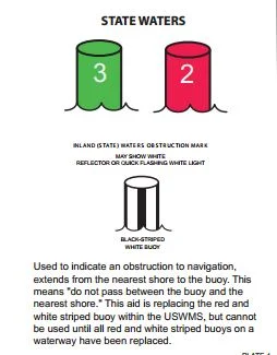
Below are a few buoys that need to be understood
Red Right Returning 3rrr's
By the way, if you're using your chart for trip planning purposes, you may like non-navigational charts/maps better. We find a fish-n-map chart inexpensive and very useful.
Our favorite for planning is a full-color waterproof laminated tourist map with topo lines, but it does not show depth or rocks.
A warning some boaters don't heed,
Please don't take off anywhere with just your chart plotter or portable GPS, iphone, or whatever gadget is popular today. You really need to have a hard copy chart or map. (and a compass too) If it just sits rolled up in the corner, that's fine. You probably don't use your whistle, flares, PFDs, or any number of emergency items either, but you still carry them.


No comments:
Post a Comment
The comment box was recently restored after being misplaced for a few years. Feel free to offer comments. Use the e-mail box to ask questions.