ATTENTION!

This site has oodles of information about boating and the San Juans, it helps to use the search box BELOW to find what interests you.
Search - "things to do" or try "places to go"
search - Sucia Island
search - Friday Harbor
search - hiking or bicycling
try - kayak - try CAMPING - try Anchoring

++++ ============================= All Posts Below

Current Posts Below
Showing posts sorted by date for query docks. Sort by relevance Show all posts

3/15/2020

16 public floats and docks you should know about in the San Juan's

          Obstruction Pass           Blakely's                   Deer Harbor          Roche Harbor                 
          Friday Harbor               Jackson Beach           Hunter Bay           Prevost Harbor
          Washington Park           La Conner                 Eastsound             Odlin Park
          West Sound                   English Camp           Orcas Landing      Olga

     When visiting the San Juan's many of us  head for the great marine state parks and for good reason, that's where the floats, campgrounds and amenities are located that vacationers desire.
   
    However,  if you want to get off the boat and see something other than campers and boat people you have two choices. #1 dinghy ashore somewhere or #2 find a public dock and head out.  This list and description of San Juan area docks excludes the state parks because most marine state parks are landlocked or waterlocked leaving visitors with no opportunity to explore beyond the park.


Sixteen  public docks organized and listed in no particular order.

     Obstruction Pass, this county float and boat ramp is located just inside Obstruction Pass on the southern tip of Orcas Island.  Nearby pass traffic wakes make this a punishing place to tie up even for just the two hours allowed, however rendezvousing with friends on shore or heading out on bicycles for a strenuous ride to the top of mount Constitution may be just what's needed to round out a perfect cruise. Tip: For longer visits, anchor nearby after dropping off passengers and bikes, then drag dinghy up onto float or shore. Your boat will thank you when you return.


Obstruction Pass county dock Blakelys fuel dock
Obstruction Pass county dock in red circle at top
Blakely's at bottom

     Blakely's is a conveniently located fuel dock about halfway between everywhere we go in the San Juan's. They are just inside Peavine Pass on Blake Island. On shore is a small store and deli bar famous for ice cream cones to savor on the lush waterfront lawns. Grazing deer share the lawn so watch your step. The dock is rather long with plenty of room on both sides to tie up big and little yachts and still not interfere with those getting fuel. They offer overnight marina slips in a very protected tiny cove. The island and roads are private so boaters may not leave the resort property.
Blakely island fuel dock and taxi
Fuel and store dock at Blakelys is long and you may tie up on either side to avoid wind or current issues.


     Deer Harbor,  on the west end of Orcas Island at the end of the road is diminutive Deer Harbor community and  marina.  You may purchase fuel and snacks, get ice and rent a slip. The county dock is actually the same dock as the fuel float. Simply tie up out of the way just past the fuel dispenser.  The county section is painted yellow and accommodates several runabouts or one large yacht. This is an excellent jump off point for kayakers heading for Jones Island or dropping off people catching the San Juan Transit mini bus. The bay out front is calm and rogue wakes are few, anchoring room is abundant, restrooms, showers and laundry are on wharf.

Deer Harbor on Orcas Island, fuel dock, showers, laundry, public county dock
If you squint, looking under the main wharf at Deer Harbor, you can see the yellow painted county dock.

1/09/2020

Farmers Markets on San Juan Island - Saturday Markets on Lopez Island, Orcas Island Saturday Market


Saturday Markets in the San Juans

If your running out of things to do and places to go when cruising the San Juans, try Saturday Markets, Farmers Markets and Craft Fairs.  Lopez, Orcas and San Juan Island, all have regular scheduled markets in the summer months.

 At Friday Harbor on San Juan Island you will find every Saturday morning, April through September the "San Juan Island Farmers Market" at the Brickworks Plaza. Bring your appetite for breakfast or lunch and feast on the island cuisine, then bring home locally made arts and crafts.
Friday Harbor San Juan Island, farmers market

Tie up in a slip, or anchor out and use the dinghy dock, its a very short walk.


In Lopez Village on Lopez Island look for the "Lopez Farmers Market" next door to the community center. Open 10am to 2pm mid May into September every Saturday. Plan on having lunch and picking up some local produce and seafood. Local crafts people and artists will be  displaying their work.

Lopez Village Lopez Island in the San Juan's, farmers markets

Berth at a slip in Fisherman Bay and walk about a half mile to Lopez Village.
OR go by dinghy and land right in town -  here's how >>> Lopez Village by dinghy


Don't miss the "Orcas Island Farmers Market" in Eastsound on the Village Green, Open every Saturday from 10am to 3pm  May through October.  Crafts, arts, food, gardeners, museum and history booths, you will find just what you need. 
Eastsound county dock on Orcas Island, farmers markets
Eastsound county dock

Village Green in Eastsound on Orcas Island, music festivals, farmers markets,
Music festivals on the green

Use the county dock at Madrona Point or anchor out, and dinghy to the dock, its just a block or two to Eastsound.

Anacortes, Bellingham, and LaConner should be on your short list of things to do & places to go!

At Anacortes the Farmers market is at 611 R Ave in Anacortes, just a few steps from Cap Sante Boat Haven, and runs 9am until closing every Saturday beginning in May.
Don't miss the "Waterfront Festival," normally held in June

Bellingham boasts a Farmers Market that is just a one mile walk from Squalicum Harbor at Depot Market Square, Railroad and Chestnut streets, open 10am to 3pm April thru Christmas.

Lastly, LaConner on Swinomish Channel has several public docks downtown where moorage is on a first come basis. As of this writing there is no established close by Saturday Market, but they have an extensive menu of shops jus steps away on main street. Visit the chamber website calendar of events right here.   http://www.laconnerchamber.com/chamber_calendar.cfm


8/01/2019

What is the best time of year to visit the San Juans

   The answer is simple if you are coming by boat, it is July and August. If by car, RV or bicycle, the same, July and August.

     Okay, by the time August gets really warmed up, the spring flowers are gone so if flowers are your goal, then early July is better and Butchart Gardens should be on your short list. What about natures crop of young birds, orcas, seal pups and spotted fawns, early July again, even June.  

     Lopez Village, Eastsound and Friday Harbor all have farmers and craft markets open from about May through September.  farmers markets

     Coming for great sailing and empty parks, consider June first. July and August are known for little wind, full docks, and crowded ferries. The fourth of July will be standing room only and reservations required, however the Friday Harbor parade and fireworks are worth the effort. Fourth of July celebrations across the San Juan's

     Foggy drippy weather out in the straits and particularly the Strait of Juan De Fuca may be expected anytime but August and later into fall is more of a sure thing. Late summer may be your best bet for crowd free balmy soft breezes one day and crispy rail down double reefed reaches the next.

best weather in the San Juan's at Roche Harbor,  4th of July
4th of July at Roche Harbor


5/09/2019

San Juan area campgrounds with boat ramps

      If camping is your primary activity and your boat is for day use such as exploring, fishing and crabbing, 
you will find these parks of interest.

On the mainland:

  • Washington Park in Anacortes - located one mile past the ferry landing.
Washington Park boat ramp in the San Juan's, the fastest and shortest way to Friday Harbor
Washington Park boat ramp in Anacortes
Excerpt from their website: In the campground there are 68 campsites, 46 have water and electrical hook-ups. These rent for $27 a night. There are 22 non-utility sites that rent for $21 per night. There are 25 sites available on a first-come, first-served basis. Please note that reservations must be made 14 days in advance. A sewer dump station is located near the park exit. Camping check-in and check-out time is 1 p.m. The campground is open year round. Please note: Maximum stay limit is 14 days. Visit the reservation website.  click here >> Washington Park The boat launch at Washington Park was developed and is maintained for the specific use of recreational boaters. Boat launch parking is $9/day and boaters may stay a maximum of 14 days. The two lane launch ramp is suitable for all trailer-able boats, power or sail.  You may not overnight at dock, but may anchor nearby. Ramp is a short walk to campground.

  • Deception Pass State Park - roughly ten miles south of Anacortes.  It is important to note some of the differences between Washington Park and Deception Pass Park.  While Deception Pass camp sites exceed three hundred in three different campgrounds, none are walking distance to the four lane boat ramp at Cornet Bay. However the modern well designed boat ramp claims to have two thousand feet of side tie moorage and overnight at the dock for up to three nights is allowed. Anchoring close by is simple and free. The ramp parking lot is massive and long term is allowed for a fee.
Deception Pass boat ramp at Cornet Bay
Four lane all tide - Cornet Bay ramp at Deception Pass Park is open 24/7


Lastly, Those putting in at Washington Park will be much closer to the inner island area after simply crossing Rosario Strait, but those putting in at Cornet Bay will have to deal with the pass and a longer run up Rosario or an even longer run through Swinomish Channel.  These are not insignificant differences and should be well considered according to your overall plan before making your decision.

On the Islands:
  • Odlin County Park on Lopez Island
Odlin park has thirty one campsites and reservations are a good idea.  The boat ramp is sub parr at best and is not suitable for anything but a small skiff and a four wheel drive. There is no ramp dock and best used at high tide only. The ramp is a short walk to the campground.
  • San Juan County Park on San Juan Island
San Juan park is very similar to Odlin park with twenty six sites, they also take reservations.
The boat ramp is also sub parr and should only be considered for skiffs being hauled with four wheel drives, again the ramp is in the park and there is no float.
  • Moran State Park on Orcas Island is a State Park as is Deception Pass. They boast over one hundred campsites, some suitable for RV's.  Moran park is not ocean front and does not have a salt water ramp, however it is only five miles to the county boat ramp at Obstruction Pass.
          A private park alternative on Orcas Island is West Beach Resort in Eastsound, they have         camping, docks and a boat ramp, suitable for skiffs and four wheel drives.


  • San Juan Island:  If you take your skiff to San Juan Island and stay at a private residence, rental or hotel you can put the boat in at Jackson Beach day use park. The ramp is well designed, has parking and a dock. Jackson Beach is about two miles from Friday Harbor.

Ferry's and trailers:
        Don't forget to check the ferry schedules and fares, hauling trailers on the ferry can get expensive and frustrating - very few do it!


My recommendation for mainland camping is that you get a reservation and camp at Washington Park, 
the run time to Friday Harbor is under an hour, the entire San Juan area will be at your door.

4/28/2019

First Timers Guide to the San Juan's

Matia Island, San Juan Islands travel cruise itinerary
Matia Island
 

  From time to time I refresh my thinking and remember our first visit more than twenty years ago. Specifically what a pain it was not knowing the simplest answers to questions many of us take for granted today. This post is written to help new cruisers headed to the San Juan's needing the same simple answers we needed.

     I define the San Juan cruising area not by county or even country, but rather by places we want to visit and spend some time. But that also means, places we have the capability to get to without too much effort or time.  So that being stated, I think of Port Townsend and Deception Pass Park (Cornet Bay), and Swinomish Channel as our loosely defined southern boundary.  I think of Vancouver BC and Nanaimo as our northern most point, and everything in between Vancouver Island and the mainland completing the east west box. Keep in mind, with a day or two extra, you can run down to Olympia or up to Princess Louisa Inlet, but for this discussion, we are sticking to the core San Juan Island area and what you need to get there.


Basics

  • You need a boat, but you can rent a sail or powerboat in Anacortes or Bellingham if you prefer, and it doesn't take much experience to qualify.
  • Size matters, bigger is more comfy, costly and feels imminently safer in a storm. As size goes up, so do your skill requirements. Once past about thirty five feet you will find you don't fit at some docks and fuel burns at over twenty five gallons an hour. Smaller is  better at times. Eighteen foot ski and fishing boats or day sailors are very easy to get in and out at virtually all places but with all your food and gear, you will be crowded on board.  Above all - don't let your lack of a perfect boat cause you not to go. Take what you have, you can make it work.
  • Bring a dinghy, even a two person inflatable kayak is okay.  You need a way to get to shore where there are no docks. You don't have to carry the dinghy on board, you can tow it everywhere you go. Yes you can beach your runabout and let the tide leave you dry but bringing a dinghy is so much easier.
  • Sleep on board, at anchor, at the dock, or in the many park campgrounds. (there are about twenty marine campgrounds, you can camp at a different park every night) If preferred, you can spend every night at a marina or resort and sleep on shore.
  • The best weather will be in July and August, but the shoulder seasons have less people and okay weather too.
  • I suggest you plan a week, but you can make a weekend work.  If you have a comfortable all weather boat, spend the summer.
  • If you rent, don't forget you have to park your car(s) If you trailer, plan on a daily parking fee of around $12.  (Squalicum Harbor in Bellingham is free, even long term)
  • See this posting for launch ramps. ---launch ramps with long term parking  This is probably the only real planning decision you need to make before you go, but we have changed our planned take off point as we drove up the highway.  Do not start your San Juan cruise down south in Olympia, Seattle or Everett or Port Townsend or Port Angeles. If you do you will spend much of your time motoring long distances (both ways) My advice is to start in Bellingham or Anacortes using one of the ramps from the list above.
  • You need with you on the boat, a chart, or you will get lost, count on it. You should have a list of parks, marinas and resources preferably marked on your navigation chart. Get this chart. Noaa # 18421  -  We use noaa chart # 18421 you can see it by clicking here or anywhere charts are sold.  Navigation charts do not show what's on shore, (roads, city's, marinas, parks, etc) so we carry a highway map as well.
  • Don't run out and buy an expensive chart plotter. At minimum, you need a paper chart, a  portable GPS and a compass, your smart phone will probably do.  All boats need a depth sounder or you are risking an expensive grounding.

  • Sample itinerary:  #1. Begin at Squalicum Harbor in Bellingham (open 24/7).  2. Head for Friday Harbor and get a slip for your first night or every night (they take reservations).  3. Use Friday Harbor as your base, returning every night to your own slip with power, water, restrooms, on shore restaurants and entertainment. This plan will work for virtually all boaters regardless of  gear, experience or creature comfort requirements. None of the Marine State Parks have reserve-able docks or anchor buoys, everything is first come first gets it. This means you should plan on anchoring and using your dinghy,  it also means when someone pulls out you may grab the spot at the dock. Rafting is the term  used when several boats tie together at anchor or the dock.
  • Sample itinerary:  #2. Begin at Squalicum again but this time head for Matia or Sucia. Next, Jump over to Stuart and then Roche Harbor or Jones, then to Friday Harbor, then Fisherman Bay. This itinerary will make sure you have a shower and food store available (Roche and Friday) when you really need and want both.  
  • Fuel is readily available but you should try to have a minimum range of seventy five miles just to be sure should you encounter adverse conditions.
  • How many days you spend at each park is up to you, your car and trailer will be waiting in the free parking lot when you circle back to Bellingham.

  • Get my San Juan Islands Cruise Guide, it  has all the parks, marinas, fuel, resources, phone numbers, etc. and is written specifically for visitors coming by boat. My companion book, the San Juan Islands Travel Guide is written for visitors coming by car or boat.
              San Juan Islands Cruise Guide     -----   San Juan Islands Travel Guide
         Don't be cheap, the books cost less than a meal and will pay for themselves in saved frustration,  making your cruise a real success.
  • Lastly, I can't address everything you may want to know in a single post, so I suggest you search this site and read some more articles. There are several with detailed day by day itineraries. Next, after becoming more knowledgeable about what and where you want to go and do, set aside a week and go. It really is that easy. The central cruising area is small enough that you can completely change your plans on the fly. You don't need reservations, you don't need a plan, you don't even need to bring food, just grab your gear and boat and hit the road. OH - bring some cash for, fuel and park fees and that food I just said you don't need.
If you happen to see us on Kraken somewhere, please say hello. We hope to be anchored in Fisherman Bay for the Lopez Island 2019 4th of July show.

John and Linda
              feel free to use the e-mail contact form with your questions


12/13/2018

How to Secure Your Yacht Like You Want To Keep It Forever

Set the brake, turn towards the curb, leave it in reverse and tie the reins with a quick release knot.  

These familiar sounding hints may work for some things, and horses, but not boats.  

Dock lines are important, seems like an obvious observation, but I’m astounded at how many times I see boaters tying up as if they didn’t care about what may be their 1st or 2nd  most valuable possession, spouses and children excluded of course (for some).  Some skippers treat their vessels as if it were a horse, just throw the line around the hitching rail and she be there, arrr, when I come back must be their logic. In their defense, some of these  boobs cowboys (boobs removed to be pc) have never been anywhere but on their trailer, so dock lines aren’t used. But still, If they can’t tie up their boat, how can the rest of us trust being around them.

Enough with the rants, every boat needs four or more lines going from the boat to the float.  I know, people make exceptions sooner or later, such as, “It was just a five minute stop over to get ice, or the water was so smooth,” that’s fine, you’re the skipper and it’s your call.

Four or more huh?  Let's see, one bow line, one stern line, one spring line to stop forward surges, one spring line to stop backward surges. More lines are needed for nasty conditions, such as big swells hitting you all night and day, passing boat wakes, high winds. The condition of your vessel or the docks puny cleats and deteriorating condition are all clear signs that you may need more lines.

Learn from others or suffer the expense of learning yourself is a good piece of advice.  I have on one occasion experienced a brand new line chafe through and part in only one night while tied to an exposed outside float. A new line that rubs on a smooth rounded fiberglass gel coat will lose the battle in one night if it is snapped taught constantly by your boats surging.  Plus the gelcoat will suffer in case anyone cares. The answer is loose lines, shock absorbing snubbers, chafe protection padding or hoses, more lines for when the first one breaks, or park somewhere else. Of course for short time periods you can order your crew to stand there and hold the boat off while you buy the beer and ice. 

Don't forget to have oversize fenders, but even that wont save your boat if you park somewhere you shouldn't.


how to tie your boat using spring lines

Ahoy!

9/10/2018

Excellent Eight Day Cruise Over Labor Day Weekend 2018


       In an earlier post I made a wish list for my summer travels, this is a follow up. But first a link to my earlier post so readers may see what I wanted to do and compare that with what we really did.   Ideas for this summers cruises posted in January 2018

      Because of a hectic summer with two weddings and a Boston trip we almost stayed home, but just before Labor Day I said lets go or forever wish we had. On the morning of our departure we were battening down and about to hit I-5 north when a neighbor came walking by.  He is also a San Juan traveler so we ended up talking for two hours.

     Finally heading out, we immediately stopped to fill the trucks 33 gallon tank, next stop besides the usual rest areas was Seattle where we picked up another 29 gallons.  It is always a shock to find out we only have a few gallons left when I am hauling 10,000 lbs.  Next stop was Winco in Tulalip where we purchased our entire food and beverage supply. No shopping list for us, we just walked the aisles and filled the cart with everything we liked, except we forgot to get a sack of ice for our drinks even though we talked about it in the check out line.

     We arrived in Bellingham about two hours before sundown, took the port of Bellingham exit and went straight to Fred Meyers for the forgotten ice.  I am thinking, I hope this 30-40 minute delay doesn't bite us, especially after losing 2 hours gabbing at home. (see, no stress for me!)

      Splashing the boat and parking in the free lot was a breeze as it always is, but hosing down my salty trailer got me all wet because the water hose is full of holes. ( zero kudos to Squalicum Harbor staff in charge of  wash down hoses.)

       Staying at the transient dock and paying the tourist per foot fee just didn't interest me this trip, I wanted to get underway.  I said to Linda, we have one solid hour of daylight and I can anchor in the dark at Inati Bay  if I have to, so off we went.  We arrived at Inati Bay on Lummi Island almost exactly at sunset. I set the anchor in fifteen feet, thirty feet from shore, opened the first box of wine and broke out the barbecue as darkness settled around us.  I remember looking at the ink black water and the nearby shore cliffs blending together and thinking how anchoring in the dark would have meant dropping the hook a lot further out.

       Day 2. Got the coffee dripping first thing. Last night was great, stars were out. Actually slept in a little.  We listened to the weather radio for conditions expected if we head for Victoria. Sounds like a go but I'm not sure. With deteriorating conditions expected that evening we might be headed into a gale if the front blows in early, but at this point I am set for going to Victoria.

       We up anchor and head south around Lummi so I can get a better picture of the Lummi Island Campground sign (takes two minutes), when we clear the south end and head northwest, I'm staring right at Clark Island, Clark is another on my bucket list of places I need new pictures for my planned updated Cruising Guide.  We grab a buoy at Clark and dinghy ashore.  I haven't changed my negative opinion of Clark but I did get the pics I wanted. Linda thinks I'm unfairly maligning Clark but I am more convinced than ever that putting a state park in the middle of Rosario Strait is a dumb, bordering on dangerous idea.

Clark Island campground
This is the view of the trail leading off the beach at Clark to the well hidden six site campground. To find this trail, anchor or use a buoy in the cove  on the east side of  Clark.  Now walk all the way to the very far south end (left end) until you are blocked by boulders and cliffs. There it is, you can't miss it. All the other dozen or so camp sites are waterfront along the beach.
 

6/21/2018

The Fastest Way to the San Juans On Your Own Boat Begins in Anacortes at Washington Park or Cap Sante

Traveling to the San Juan's requires a starting point,
 a jump off point where you can leave your rig.

"Washington Park" and "Cap Sante Boat Haven" in Anacortes fill the bill.


map of Washington Park and Cap Sante in Anacortes Washington


Washington park has a campground and a boat ramp with a float.  You can reserve your camp site in advance, launch and retrieve your boat every day to make day trips, or take an extended cruise into the islands knowing your campground is waiting for you when you return.  You may also choose to not stay at the campground, just launch your boat, and leave your car and trailer in the long term parking lot while you're in the San Juans.

Cap Sante does not have a ramp but has a sling and a travel lift to launch your boat, they can also assist stepping sailboat masts. Guest space is usually available at the dock and long term parking for your car and trailer are just steps away.  You should make arrangements ahead of time for the travel lift and guest docks

There are several other places I recommend over these two depending on where I'm going and other plans.
Take a look at this post >>  Trailer boat ramps

4/23/2018

Is Squalicum Harbor in Bellingham the best way to get to the San Juan Islands? - YES!


     Places to go, and places to travel are easy to find in the San Juans.  For me cheap travel is part of the deal.  What can be less expensive than going on a cruise with your own boat, it's like having your own condo rental or vacation house with you all the time. Okay maybe boat camping is a little squeezed, but the big problem is, where do you launch, and where do you leave your car for a week or more?   Squalicum Harbor in Bellingham is a resounding first choice and parking is free, no others come close for time, distance, convenience, facilities, none in my opinion.!
Squalicum Harbor launching ramp in Bellingham, Wa

Squalicum Harbor launching ramp chart map


     Marked on the chart above with red dots is a four lane two float all tide modern 24/7 ramp, parking, and the overnight visitor docks. The parking lot is huge and they have an overflow lot too. Fresh water wash down hoses are free for you to use.  Ramp fee is $5 and there is no parking fee, that's right it's free, even long term is free. How cheap can you travel, ( I mean less expensive) Next to the parking area is a restaurant, 24 hour bathrooms, and showers. Across the street is a marine store.  Out on the floats, they have transient boater dock space.  Payment is self serve at the automated kiosks.

      You may think by looking at maps that Bellingham is far from the Islands, but it is actually the closest jump off point for travel to Sucia, Matia, Patos and Stuart.  For those camping and traveling on a budget it's your only choice.link to really great map with parks marked, click here

3/10/2018

Victoria Cruise Itinerary and Customs at Roche Harbor

Note: this  is a very old post I am re-posting so some prices will be off.

Suggested Cruise to Victoria BC with Whale Watching
 and San Juan Islands Stop Overs
This article is for first timers to the San Juan Island area and has the answers you may be looking for.  Timeless advice to make your first trip a fun success.
  • places to launch and stay on your boat
  • distances between stops
  • customs and immigration
  • alternate planning
  • what to expect
  • basic boating information 
Study this map and familiarize yourself with names and places. 
 (Find Victoria, Roche Harbor, Swinomish Channel, Deception Pass)
Map showing Victoria Canada, San Juan Islands, Roche Harbor, Friday Harbor, Squalicum Harbor, Anacortes


Lets start this Cruise at Cornet Bay in Deception Pass State Park
(Your going to Canada and back, did you remember to bring your passports and Children ID's? the rules are changing)


Cornet Bay boat ramp in Deception Pass park

Boat launch at Cornet Bay (Deception Pass)

Day one, you arrive at Deception Pass and its probably late in the day and your tired, so lets plan on spending the night right here  on the boat securely tied to the dock at Cornet Bay.  You will pay a launch fee and $10/day parking, plus 50 cents a foot for spending night at dock. Pay at the self serve kiosk. If your not sure of when your coming back simply estimate, leave a note explaining, the ranger will understand.  The ramp is very good, all tide. The parking is huge, you will not have a problem.
      There is a park store, but you should have done your provisioning in Anacortes.


Deception Pass bridge

Heading westward facing an incoming current, (another ten minutes and we wouldn't have the speed to overcome the 7+ mph current)

Day two, leg #1, our destination is Friday Harbor, but first you must time the pass.  You should already be familiar with the tide levels and  times at Deception Pass (download a page from any of of dozens of sites including NOAA) so cast off at high or low tide. You can be  half an hour early or late, this gives you a one hour window. (it takes just ten minutes to reach the pass from the dock)  If you are catching a falling tide (current is going out to sea) you can be very late but standing waves may scare you and the crew as you take a fast sled ride and shoot out into the Strait of Juan De Fuca.  If you are late and  head out on a rising tide, your boat may not have enough speed to overcome the in rushing torrent, and your stuck until the next slack water. The pass is not a problem, it is narrow with fast water for only about 250 feet, but slow sailboats can  meet their match every four to six hours.


read more

2/01/2018

Jones Island is the Absolute Best Marine Park in the San Juans - Period

This is a reposted post I think is very worthwhile.


Jones Island offers a wonderful experience for boat camping and exploring the San Juan Islands. Its proximity to major marinas and harbors, such as Deer Harbor, Roche Harbor, and Friday Harbor, makes it a convenient and attractive destination.

Starting your kayaking adventure from Deer Harbor, with its calm waters, can be a great option for exploring the surrounding areas. Roche Harbor, known for its resort and as a departure point for trips to Canada, is another nearby destination that adds to the appeal of Jones Island. Additionally, Friday Harbor, the largest city and port in the San Juan Islands, is relatively close, making it easily accessible for supplies or further exploration.

With its strategic location and the variety of neighboring destinations, Jones Island offers a great balance between tranquility and accessibility. It can be an ideal choice for families looking to enjoy boat camping and explore the beauty of the San Juan Islands.
This post is all about Jones Island Marine Park in the San Juan's


         All of Jones is a state park, the north cove is preferred by power boaters and sailors alike, inside you will find a protected bay with docks and anchor buoys, plus room to anchor if the five buoys are in use.

Map locating Jones Island - post describes camping facilities

        The south cove is favored by kayaker's, there are several campgrounds and the island has running water, fire pits and picnic tables. On a sunny summer weekend it would not be unusual to find several large groups camping with many first time kayakers in guided tour groups.  Offshore are a few anchor buoys.  The south cove is not protected from San Juan Channel traffic or winter storms so the beaches are piled with sun silvered driftwood.

Jones Island State Park in the San Juans

        The North Cove is absolutely wonderful, There is a brand new dock, anchor buoys, a steep gravel beach (good for dinghy's), and room to anchor. The cove is protected from all but the worst north winds (very infrequent) On shore are lots of tent sites, each with picnic table and fire rings.  There is a nice mowed lawn area for games and grazing deer.  Bathrooms and running water are clean, cool, clear and convenient. 

Jones Island in the San Juans - blog post describes campground


            The island has several hiking trails, rated, easy and moderate. From the trails are magnificent views of the surrounding islands, and waters.  Bring your camera to Jones, you will want to preserve the memories to show your friends that aren't as fortunate as you.

Boat camping at Jones Island Marine Park in the San Juan Islands

NEW -  NORTH COVE DOCK AT JONES ISLAND

12/26/2017

Five Things Everyone Should Know Before Cruising the San Juan Islands

Fun Observations and Frivolous Knowledge  for 

All Boaters new to the San Juan's (repost)

#1 Hugely fluctuating water levels   (tides)

The San Juans have high and low tides every day, some very high, some very low. This means you will need to be prepared to deal with going ashore at locations lacking floats.  The easiest solution is to bring a dinghy; if you don't have a dinghy I suggest you buy a cheap inflatable boat or 2 person kayak for around $75.  Once in the San Juans most people simply tow the dinghy everywhere they go, or deflate and stow it away. Those of you going in a ski boat or skiff may be thinking you can beach your boat, which will work, but only for a few minutes. On a falling tide in ten minutes your boat may be high and dry, unless you can carry it, your stuck until the tide comes back up. On a rising tide your boat will float away while you're on shore.  Since your going to anchor in six feet of water at low tide you will need one hundred feet or more of anchor rode to accommodate a ten foot plus increase at high tide. Smart boaters bring two anchors and rode and a dinghy they can carry up above high tide.
San Juan Islands - very low tide at Matia


#2 Strong Swirling Currents (in places)
San Juan currents are notorious, and the root of many stories. For fast planing boats you can pretty much ignore adverse current; however slower boats live and die by planning passages to get an assist from the current. A typical sailboat may putt along at 4.5 mph, against a 2.5 mph current their real speed over ground is 2 mph.  Going with the same current their sog is 7 mph.  So a ten mile passage takes 5 hours the dumb way or 1 hour 25 minutes the smart way. There are many prediction and forecast books and charts available and online.  While you don't need a publication, I recommend that you buy something and keep it with you. I would also go online and print out a tide schedule for the time and area you expect to cruise.  CLICK BELOW for Rosario Strait at Guemes Channel
NOAA tide forecasts
In a nut shell, here's a simple rule of thumb to follow.  On a incoming or rising tide, the water in most straits and passes flows "north" while during a falling tide the water reverses and flows "south."  When the current hits an island straight on, the water will split and flow around the island usually at a slightly higher speed creating eddies at headlands and the tips of the island.
San Juan and Gulf Islands Current Atlas

San Juan Islands current charts


#3 Weather could be fog  (pea soup is the term)
You can get lost in the dark, in the fog, or just plain lost on a sunny day.  You need to bring with you a chart, and you would be smart to protect it from getting wet or torn up. I sandwich mine between two clear acrylic sheets held together with velcro.
Some will say the chart needs to be new and of the highest resolution, which may be true for ship captains and other navigators.  What were talking about here is not getting lost, even a google print out may do the trick.  If you are going to boat in the fog you must have a compass, and  GPS, a portable handheld GPS will do fine and some new phones may do the trick too. (in thick fog you will go in circles and be totally disoriented without a compass) A gps will not replace a compass in rough water and fog, a gps is much too slow  reacting when you are getting spun from broadsides or quartering waves (broaching) you need both.   Many times in the San Juans visibility may be down to 3 or 4 miles and you think you can sneak across some open water to the next island, and you probably can, but if the fog thickens to pea soup you will be glad you have your compass and GPS.  BTW, fast boats can't always go fast when waves and swells stack up. And only very dumb skippers go fast when they can't see.
San Juan Islands fog hiding a ferry
See the ferry approaching the anchored sailboat?

#4 Wind or lack of wind  (sorry sailors)
OK, here's some bad news for sailors.  The San Juans are not known for great sailing winds in July and August. Out in the straits (Haro, Rosario, Georgia, Juan De Fuca)
you may get some decent sailing, but inside the islands, don't bet on it.
Sailing with reefed main in cold weather
Sailing in April rain with reefed main


#5 Crowd control   (no worries)
Most likely you won't have any problems with crowds except on the 4th of July and Labor Day.  The good side is that you will always find a place to anchor, even on holidays, the dinghy ride may just be a little longer for some.  Most marinas take reservations and you may as well take them up on it, but you don't need to.   I suggest you slow down a little and enjoy the freedom of not planning ahead, take one day at a time and see where you go.  Lastly, because this area is so close to Bellingham and Anacortes many boaters are day boaters.  At the end of the day they head for home, leaving some resorts and parks half empty, especially on weekend Sunday nights. Monday or Tuesday are good days to begin your outing if you want to be alone.
Roche harbor dock on holiday
Fourth of July celebration in the San Juan Islands at Roche Harbor Resort
Roche Harbor summer celebration with children

Roche Harbor balloon chasing contest


Roche Harbor 4th of July balloon contest for kids in dinghys
yes, there was room for more, lots more


Expenses
DNR buoys are free (Cypress Island) State Park buoys are $10, many park floats are 50 cents a foot,  Marinas charge between 75 cents and $2 a foot. Gasoline is a little more expensive than on land, but not much more.  Food, groceries, ice are just a little more than the mainland but very fair priced overall.

How many days to plan
Plan a minimum of four days, but up to two weeks depending on what you like to do. (I like to sit on the dock at Jones Island and read my book between naps and walks, then I make a campfire in a empty tent site and cook Kielbasa followed by a glass of wine. Then retire to my boat for a good nights sleep.  The next day, do it again)

Salt Water
Salt water drys sticky and does not suds up well with soap, you will get it all over you and your boat, count on it.  After a week you will look forward to a shower.  Your boat will be covered with salt crystals.  Most marinas have little water and don't want you washing your boat.
Squalicum Harbor in Bellingham has boat and trailer fresh water wash down hoses in the parking lot.  You should use them each time you dunk your trailer.

Provisions
For the most part you will want to provision before you leave on the boat.  Anacortes and Bellingham have all the big stores and each has a West Marine store.  All the resorts and towns have grocery stores, if you drive a fast boat, supply's may be only minutes away, putt putt's should work a store visit into your circuit.  I say circuit because most cruisers will follow a circle of some sort trying to hit many stops.  We find that ice needs renewing after four days, so a stop over at Friday Harbor, Deer Harbor, Roche Harbor, Blakelys, or Orcas landing fills the bill.  All these places  except Orcas, have gas and showers.  Showers will cost a handful of quarters so be quick or be poor. Cold showers are free. Lopez Village has free showers but no dock so you will need a dinghy.how to dinghy to Lopez village

Garbage
All the parks are pack it in and pack it out, the marinas have dumpsters.  If you are new to boat camping you will find garbage to be a pain because you are not used to storing everything in your boat.  Little things like empty water bottles suddenly take space you don't have.  You must give careful thought to what you are bringing, and the garbage it will generate.  We don't use disposable bottles, minimize pop consumption, and try to have campfires to burn burnable trash.  It is against the law to toss anything, (even a apple core) in the water.

Animals
Your dogs must be on a leash, period, everywhere.  Raccoon's are on all islands and will climb right into your boat or kayak in the day time if you let them.  Deer are all over too, but they shy away, except on Jones Island where you can hand feed them.
Otters live under most floats and docks, they will crawl all over your boat, get into things and make a mess.  Otters also will mark their territory by pooing on your stuff, dock lines are a favorite.

Bathrooms
All the parks have nice composting toilets, (each island mentioned for overnight is a park) the rangers service all parks on a regular basis.  You will be pleasantly surprised at how clean the facilities are.

Where to go:
Your destination is simply that, its the journey getting there and the experiences on the way that make a trip a wonderful vacation. Try the links below for some Island Park descriptions.

Emergency's 
Bring your cell phone and charger, bring at least a portable handheld marine radio, bring basic first aid kit, call the Coast Guard, they can be there pretty fast, or arrange for vessel assist on your credit card, bring a friend with a similar boat, then you can help each other.

9/26/2017

Twenty Marine Parks - Twenty Public Docks - Five Boat launching Ramps in the San Juan Islands


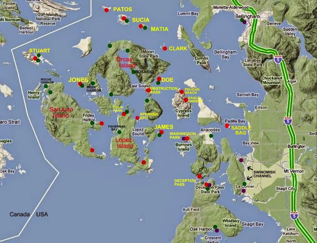
Map of San Juan Island Area
With selected Parks, Docks, and Trailer Boat Ramps
Map of San Juan area parks, docks, trailer boat launch ramps
The  boat ramps (purple) are all on the mainland


 •  Boat Ramps = Purple    Parks = Red  •  Docks = Green

Most docks (floats) are in parks, resorts, marinas and may be used for overnight camping. Boat launching ramps have long term parking.  Parks without docks have anchor buoys or areas suitable for anchoring.