• Discover boat-in spots from Sucia’s anchorages to the trails of Stuart and Jones Island
• Experience the Islands
• Visit bustling Friday and Roche Harbors
• Find serene, secret coves • Your adventure begins now!
New Feature
Below every post is a satellite view hot link - You may drag image to your area and/or use the plus button to zoom in all the way or click street view when enabled.
++++ ============================= All Posts Below
Current Posts Below Note: The first few posts below are for first timers and stay on top — New posts are scattered throughout the website — use the search box or look in archives on the left side to find your interests
What do boaters think about during the off-season when they’re not on the water?
Many of us think about nothing at all, but lately I have been thinking about my San Juan Islands Dinghy. And I got a little sidetracked. I should be thinking about boating and off-season planning.
Dinghy's, tenders, and shore boats come in a dizzying array of shapes and sizes, and the ongoing "best dinghy" argument is far from complete in my limited mind.
But right now I'm wondering if the pointy end of a dinghy is really needed. I mean the part that is normally above water.
So here's the question: When comparing a 8' pointed dinghy to a 8' blunt nosed dinghy (some call them prams, others punts) do they both have the same load capacity? rowing, sailing ability? I think if you take a 8' flat nosed dinghy and add back what it would take to make a decent pointed end you would in essence then have a 9.5' (give or take some inches) pointed dinghy. Am I missing something here?
If I'm correct, it means a flat nosed dinghy of a given length may actually be a bigger boat (other issues and factors being equal) than a pointy dinghy of the same length overall. Right!
I think carried to extremes this line of thinking means a rectangle boat is bigger, followed by a square boat as being the best shape for big loads. So a barge may be the shape it is for good reason.
So this brings me full circle back to my earlier thought, is the pointy end of a dinghy really needed, or does it just make it a smaller boat?
This picture was taken of my son by his sister. Sunset at Rolfe Cove on Matia
Where are the best places to go in the San Juan Islands for boating, hiking, and exploring?
This comprehensive post has links for almost everything for new boaters and cruisers.
The best places to go in the San Juan Islands include marine parks, small harbors, and scenic inland hikes. Popular stops range from Sucia Island and Jones Island to Friday Harbor and Roche Harbor, with additional highlights like lighthouse hikes, hidden trails, and dock-access towns that combine boating access with easy exploration.
What is there to do in the San Juan Islands?
Where to Find Essential Resources for Travelers and Boaters
All the places listed are accessible by boat, some by vehicle too. Almost every park has easy to lengthy hikes, so follow this link to all the parks All the parks. Below are San Juan area hikes that are not found in parks
Eagle Bluff on Cypress Island (my all-time favorite)
Start this 2-3 hr round trip hike at Pelican Beach. The trail to the bluff is beyond the Smugglers Cove, Duck Lake turn off and is closed until July 15th to protect baby chicks. Keep the pets and children on a leash and back from the cliff edge at the very top.
Afterglow Mausoleum at Roche Harbor
This is a short walk to the mausoleum known for a missing pillar. Begin by walking up the resort road past the chapel. Turn left on the county road and then in a block or so, left again on Afterglow Dr. Watch for signs and trail in woods on the right side.
Turn Point Lighthouse on Stuart Island
Begin this roughly two and a half mile (one way) hike at the dock at either the Prevost or Reid Harbor docks since they share the same isthmus and trailhead. Proceed on trail past sign and lots of stairs up and then down to the cove at the head of Reid Harbor. Wind your way through the kayaker campground and follow the service road, up, up and past the one room school to the intersection with Lighthouse road. Turn left and keep going, you can't get lost now.
To save about two miles of walking, consider starting this hike at the head of Prevost Harbor from the county dock where Lighthouse rd begins. As a bonus, you can ride your bikes from the county dock but be careful walking or riding because the last quarter mile going down the hill to the lighthouse is steep and littered with round rocks. We leave our bikes at the top and walk the last downhill stretch.
What are the best boat ramps to use when launching for the San Juan Islands?
Most experienced boaters do not launch from the islands. The best boat ramps for accessing the San Juan Islands are located on the mainland.
Squalicum Harbor in Bellingham
Cornet Bay at Deception Pass
Washington Park in Anacortes
La Conner along the Swinomish Channel.
These ramps offer reliable launching, parking, and access routes, while most island ramps are limited or unsuitable for overnight parking.
Taking your boat for a camping vacation cruise isn't expensive or difficult if you know the places to go and what to do.
If you're going to camp on the boat or on shore, I recommend that you start out in Bellingham or Deception Pass State Park. But if you need or want a campground with a launch ramp for your home base, you should reserve a site at Washington Park in Anacortes.
Boat ramps with parking:
#1 Squalicum Harbor in Bellingham
Lots of parking, fresh water rinse hoses, guest docks, restaurants, nice showers (you will be glad you began and ended your trip here) (updated 10/1/21) I just became aware that Squalicum Harbor has changed their free parking to FIVE days maximum. This is bad news for some of us that like to take 7-10 day cruises. I recommend calling them. (they used to stick longer term in the overflow gravel lot) Cornet Bay requires payment but at least has longer parking.
#2 Cornet Bay at Deception Pass State Park
lots of pay to park, guest docks, showers, nice place to hang out before, after and during your vacation. Only minutes from Anacortes.
#3 La Conner (south end of Swinomish Channel)
single lane city ramp, float, on street parking, cheap fees, nearby guest docks. Current to deal with.
#4 Washington Park in Anacortes
limited pay parking, double ramps with float but open to swell and waves from Geumes Channel, no guest docks, showers, very nice on-site campground, easy bike ride or hike to ferry.
#5 Twin Bridges (north end Swinomish Channel)
County ramp, limited pay parking, small float that's dry at low tide, security risk area NOTE: It's just a little further to La Conner and well worth it!
#6 Oak Harbor
free ramp, $2/day parking, guest docks nearby, full marina services nearby, long walk to town! long ways to San Juans for slow boats.
#7 Cap Sante in Anacortes
should not be listed because they have a sling, not a ramp, Cap Sante would be a second choice if you want to sling your boat in. Guest docks and big RV or trailer pay parking lot. (you can spend a lot of bucks here)
Note: Taking your boat and trailer by ferry to the islands is probably a bad idea because ramps and parking are inferior or not available. However, launching a skiff you can muscle around off the beach at a county park with no float is very doable.
Click on picture to make it bigger!
For first timers, see articles titled "San Juan Islands for First Timers"
Click below First Timers Itinerary
Click below for a satellite view of Squalicum Harbor
Note: Things change, you should check dates on all information before setting out.
I just read a website that says we can go back and forth after July 21st. This is undoubtedly subject to change with current conditions and remember what the US says and Canada says may differ so check with both sides before you cross over.
Interestingly, the last time I had a passport problem (expired) and could not find the answer online. I simply called the office in Friday Harbor and talked directly with an agent. He gave me the straight and current poop in a simple phone call. It made me realize how much I had gotten away from talking to people who actually run the show. Now if I can get certain people to quit texting for hours on end when picking up the phone is more expedient anyway.
How do you make marina reservations and find contact information in the San Juan Islands?
Marina reservations in the San Juan Islands are typically made by phone or online, especially during the summer when slips fill quickly. Key locations like Cap Sante, Friday Harbor, Roche Harbor, and Deer Harbor accept advance reservations, some use a lottery for 4th of July reservations, and parks and smaller docks remain first-come. Having phone numbers and a call plan improves your chances of securing moorage.
Sometimes it is really nice to have a slip reserved just for you.
After spending a few nights on the hook somewhere or jostling for dock space at a park that only holds four boats and has no water or shower, I look forward to my guaranteed reservation.
If you have a firm date planned,4th of July,maybe, you can call or get online and reserve a slip.
Most of these places will be able to fit you in with short notice, but plan ahead to be sure.
Did you know?
For your landbound friends and relatives (children). They can make campground reservations.
Sucia Island State Park Odlin County Park San Juan Island County Park Spencer Spit State Park Washington Park (Anacortes city park)
These five parks are boater accessible and take reservations for camping.
Think outside the box, and plan a combination land and sea adventure with your non-boater friends.
Follow this link to a post outlining a land and sea outing involving - cars - campgrounds - ferry rides - bicycles and one boat used as a taxi. Outside the box cruising
Where is the Odlin Park dock on Lopez Island and how do boaters use it?
Odlin Park dock on Lopez Island is a small, short-term county dock used mainly for dinghy access and quick stops. Boaters can anchor nearby or use mooring buoys, then go ashore for camping, biking, or walking to Lopez Village. The dock and buoys are exposed to wakes, so they are best used with caution. Odlin looks protected on the map, but it isn’t.
Odlin Park float on Lopez Island at high tide holds one big or two little boats
This is one of those really handy but easily overlooked places you may be driving by. San Juan County Parks allow two-hour tie-ups but I have left my dinghy all day, tucked in out of the way while bicycling the island or running to Lopez Village.
You can anchor as close as you want and stay as long as you want. If you are really a rule stickler, simply drag the dinghy up above high water. The park bathrooms, fire pits, and parking lot are just a 200 foot walk away. If you bring your bike like me you can ride into Lopez Village, it's only about 2 1/2 miles.
Since all of Odlin Park is totally exposed to wakes from Upright Channel, anchoring is always very rolly polly and boats at the dock get smacked around too. You can use one of four park buoys for a small fee and still flop around. Other than that, Odlin is a great place to expand your horizons.
I don't think bicycles and dinghy's work well together, what do you think?
Since parks aren't marked on charts, this snapshot may help you find Odlin Park.
Update: We have dropped the kids here again (Odlin Park). This time they had reservations for a campsite (smart idea). They left their car at Washington Park in Anacortes, and came by bicycle on the ferry to Orcas.
I know that may seem confusing since Odlin Park is on Lopez.
So here is the quick lowdown.
We started at Squalicum Harbor - Bellingham and anchored at Jones Island.
Two days later we picked them (our adult children) up at the county dock in Eastsound (Orcas) Went back to Jones where they camped on shore.
The next day we ran over to Stuart and rode bikes to the lighthouse, then came back and camped at Jones again. The next day we dropped them at the county dock at Odlin Park on Lopez, and we took a slip at Friday Harbor.
Two days later, we picked them up off the beach at Odlin Park (bikes in dinghies), had an ice cream break at Blakely's, and then hiked Eagle Bluff on Cypress.
We tried to camp at Cypress Head, but because of wind ended up anchored for a calm night at Saddlebag Island Park where they slept on shore again.
On the kids last day we dropped them and their bikes at the dock at nearby Washington Park where their car was parked. We then ran back to Bellingham and slept at the dock in Squalicum Harbor.
If you have read this far, you should see that mixing ferries, foot passengers, bicycles, and camping on shore, can all come together for a custom outing in the San Juan's. Did I mention the visit to the brewery in Eastsound?
Are there any pontoon boats in the San Juan Islands?
I'm going out on a limb here and speculating because I really don't know why I have never seen a pontoon boat in the islands. I may have seen a small Hobie Cat once, but I don't remember when.
I have read that jet skis and pwc's are forbidden in San Juan County, so that explains their absence on the water. I have seen them many times on the decks of larger yachts or being towed. Small cats with limited or no storage don't lend themselves to cruising but I would think that if a kayaker can get by with minimal gear so can a wet and wild sailor in a wet suit. This leaves me with pontoon boats. Party barges as they are sometimes called are common on lakes and rivers and easily trailered. They can certainly carry camping gear and some have cabins, so why aren't they seen in the San Juan's?
I'm guessing that pontoon boats don't do well in big waves. Except with suitable weather windows big waves might be avoided (this is a big maybe). Big wakes are another thing but they happen everywhere including lakes and rivers, especially with the advent of ballast shifting wake boats. My next thought is that party barges are the boat of choice for the younger crowd and much of the cruising crowd is a more seasoned bunch preferring beds, fridges and galley sinks.
What happens when a dinghy painter or tow line gets caught in your propeller?
When a dinghy painter, dock line, or tow line wraps around a propeller, it can instantly stop the engine and create dangerous loss of control. In real situations, lines have stalled motors, bent gear, and caused collisions. Prevention includes keeping lines short, using floating rope, and ensuring nothing trails in the water near the prop.
The prop will find any loose line you give it, count on it!
It may have happened more than twice, but that's all I remember, so I will relate just the two.
We towed this guy and his big dog in his dinghy from Orcas Landing across to Blind Bay.
In our haste, we snagged the tow rope before we got started.
We wound it up on the prop killing our outboard motor and then, since we had already cast off, we drifted dead behind the ferry that had just arrived. For a few worried minutes, I kept glancing up at the ferry pilothouse. I was wondering if the captain saw us.
What exactly does procrastinate mean?
Was he looking down at us and laughing? I was close to making a radio call, but we got the line loose and moved on a few minutes before the ferry departed.
More recently, in another boat, our dinghy line was tied to the stern rail, and I unknowingly dragged it through the water all the way from Stuart to Jones Island. And then, wound it up around the prop when I used reverse while attempting to anchor. All hell broke loose with everyone yelling what to do or not to do as the line wound up tighter and tighter. By the time I put it in neutral, our rail had begun bowing and creaking. We dropped the anchor and luckily were able to rotate the shaft, freeing the line, but someone almost had to go for a dip.
So knowing this as an ongoing potential issue, I resolved to use only floating lines and to shorten all lines so that they cannot reach the prop.
Plus I resolved to use painter tow lines that are small enough that they will break before they damage or bend my boat and shaft should another mishap occur.
The problem is I have procrastinated for years and done nothing, in fact, the rope that I snagged, I'm still using it, minus about eight inches I cut off.
My advice to myself is to follow my advice.
(update, I think the last little snafu where we wound it up may have bent something because I might be detecting a little vibration at wot. It's not too late to follow my own advice before I do it again and make the boat unusable, costing some real boat $$$$)
What is the hike to Eagle Bluff on Cypress Island like from Pelican Beach?
The hike from Pelican Beach to Eagle Bluff on Cypress Island is a steady uphill trail through forest and rocky terrain, leading to sweeping views over surrounding waterways. The round trip takes about 2 to 2½ hours and I consider it an easy to moderate walk, with a treeless 360 degree view at the top and scenic overlooks along the way. This is one of the many San Juan Islands hikes you can only reach by boat. I give it five stars
Some readers of this blog will never get to hike to the top of Eagle Bluff on Cypress Island so I snapped a whole bunch of pics while I walked along.
I'll try to keep the text to a minimum
We took the dinghy to shore at Pelican Beach, which is a Department of Natural Resources Site (DNR) see Pelican Beach
Where is Fort Whitman and Goat Island, and how do you get there by boat?
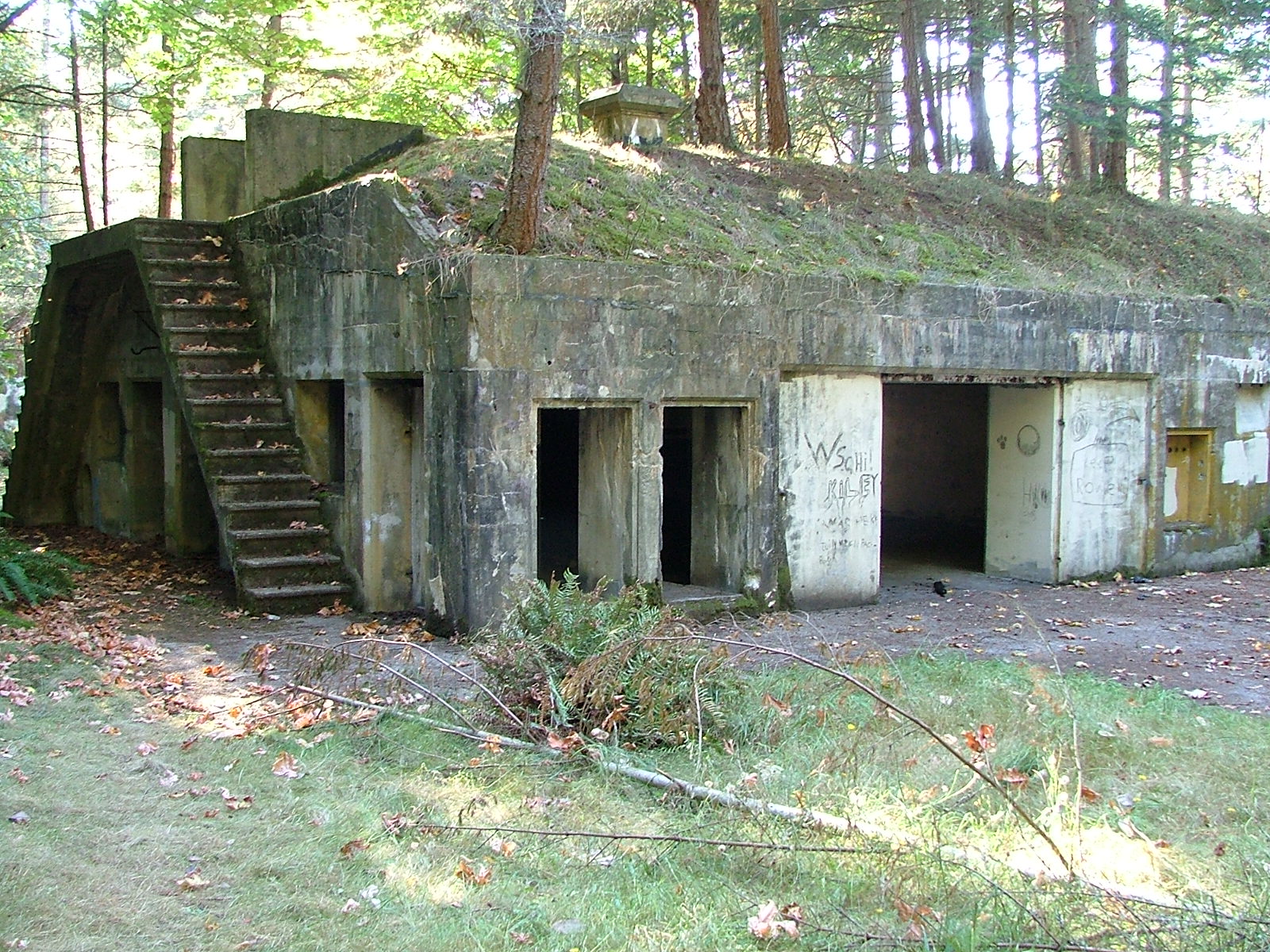
Fort Whitman on Goat Island is a hidden set of early 1900s gun battery ruins located near the south end of the Swinomish Channel. Boaters can anchor near old wharf pilings, land by dinghy, and hike a short, rough trail to the overgrown concrete structures, which were built to defend Deception Pass and the surrounding waterways.
If you like to explore ruins and go on easy hikes like we do, this is the place for you.
Fort Whitman and Battery Harrison were built on Goat Island in the early 1900's to defend Deception Pass and Sartoga Passage, thus protecting Puget Sound.
You will find Goat Island at the south end of Swinomish channel just before the dredged channel terminates in Skagit Bay. ( a few miles from Deception Pass)
The battery had four six-inch guns, so the concrete structure is quite long. Originally designed to be invisible from the water and now totally overgrown, you can land your dinghy and hike up the trail in about ten minutes.
Directions
From the dredged navigation channel on the north side of Goat Island (Swinomish Channel) look for the many pilings grouped together marking the old wharf. All you will see is a lot of rows of close together pilings with steel brackets still attached at the top. (look for the rusty old steel brackets, that's your only clue that makes these pilings look different from all the others.)Anchor to one side or tie to a piling. and then run your dinghy to shore directly behind the old wharf pilings and scramble up the bank looking for a trail heading westward. At high tide, the beach is pretty much submerged and may not look like a place to land. Spotting the seldom-used trail is really hard, you may do some bush whacking, just remember the battery is west of where you land and a couple of hundred feet back from the top of the cliff.
Have fun, its a fun and very short hike up to the old battery, oh, and bring a flashlight.
it's
trees have taken back the island and the fort
the round pit is where one of four guns was anchored
rooms and hallways are interconnected
If you want some more off the beaten path places to explore, try this post.
How can you use the Friday Harbor marina camera to check conditions before arriving?
The Friday Harbor marina camera provides a live view of docks, weather, and boat traffic, helping you gauge how crowded the harbor is before arrival. By watching the camera, you can spot open side-tie areas, check wind conditions, and see activity near the ferry terminal and anchorage to plan your approach.
On the left side of this website is a link to the Friday Harbor Camera. The live camera usually pans back and forth, covering most of the marina.
By watching the marina camera you can see the weather, the ferry terminal, vacant slips and even see if there are very many boats anchored in the cove.
If you watch closely you can see at the bottom of the gangway, A-dock, Comm dock, Walkway C and the By-pass dock, all are side tie and available for transient use. (look at the Friday Harbor marina map to get your bearings, marina map ) This area is first come first served and is assigned or reserved via the harbor master on ch 66. Looking at the space available and the dinghy dock spaces directly below the gangway will give you a sneak preview of how crowded the marina is. If you choose to stay at one of these side tie docks you will reduce your walk to shore by about a quarter mile. The Comm dock has electricity.
What is Watmough Bay like for anchoring, hiking, and visiting by boat?
Watmough Bay on Lopez Island is a secluded, well-protected anchorage with a mostly rock-free bottom and several mooring buoys. Boaters can anchor in shallow or deep water and dinghy ashore to a gravel beach, where short trails lead to viewpoints and a restroom with vehicle access. With no camping and limited walk-in access, the bay becomes quiet once day visitors leave.
This secluded gem of an anchorage is at the far southeast end of Lopez Island. No, not at popular Iceberg Point or Agate Beach.
Watmough Bay Park is on the southeastern end of Lopez facing Rosario Strait. The cute little bay is mostly rock-free, and well protected. You may hook on to one of several buoys or anchor in two fathoms a short dinghy ride from shore.
Mostly visited by vehicle and bicycle travelers the gravel beach is popular with paddle boarders and swimmers. The park boasts standard upgraded outhouse restrooms a quarter-mile walk up a level trail where the ten-car parking lot is located. Two easy hiking trails complete this worthwhile destination, there are no onshore campsites so you will have the place to yourself when the day-use people head for home.
Not exactly sure, but in the far far background (8 miles) is about where Deception Pass is.
Tips for Visiting:
Bicycle-Boating Rendezvous:
Although there is no dock, Watmough Bay can be an excellent drop-off or pick-up point for a combined bicycle and boating tour of Lopez Island.
Timing: Point Colville and Davidson Rock buoy
Large swells can be encountered offshore near where the Strait of Juan de Fuca and Rosario Strait intersect. To avoid rough waters, it’s best to time your visit for near slack water on a low wind day.
Fog Considerations:
Fog is a common occurrence and can linger for days, so be prepared for reduced visibility.
Rewarding Visit:
Despite the challenges, a visit to Watmough Bay is highly rewarding for those who make the effort to reach this beautiful and secluded spot.
Click below to see a satellite view of Watmough Bay
What is the proper or correct way to anchor in crowded marine parks?
Proper anchoring etiquette means respecting space, setting your anchor correctly, and not interfering with other boats’ swing. First arrivals have priority, and newcomers must anchor clear or move on. In crowded areas, boaters may use bow and stern anchors to limit swing, but poor setup, loud behavior, or crowding others creates problems quickly or is at least bad manners.
Oh yeah! Everyone remembers when you anchored, you were the one saying eff'g this and eff'g that while instructing your crew in dealing with your short comings.
Yeah, we remember you calling your wife an idiot and moron. Idiot for not pushing you over the side tied to the anchor is more accurate.
Loud, obnoxious, boisterous, yelling and foul language are no way to announce your arrival to the anchorage. You should be on your good behavior, you will never get another chance to make that first impression.
It's entirely possible that there is no room where you want to anchor, and you have no choice but to move along to your second choice. You can't squeeze in where you wont fit, and if you do force the issue, and there is an incident causing damage, you will be responsible financially. I think most boaters are a forgiving and helpful bunch, but not if your an inconsiderate dweeb to begin with. Hint: Ask the other boaters already anchored for help in anchoring before you anchor in their yard. They may just move over a little to help you out.
The old adage first come first served is true when you anchor, meaning the guy there ahead of you has claim to his spot, and you need to respect his anchor location and swing of his boat. The guy that comes in after you will stay out of your way,
and so forth.
Stern anchor plus bow anchor:
Many hot spots will have more boats than can hang and swing safely so skippers have taken to hooking out both directions, and stretching the boat in the middle to limit swing, thereby cramming more boats in safely. This is perfectly acceptable provided the weather agrees. If you arrive in one of these places and don't follow suit you're being somewhat within your limited boater rights, however taking an exorbitant amount of room to anchor your yacht spoils the fun so you may not be invited to sun-downers. When it gets really crowded, skippers will raft boats together, usually anchoring just the biggest boats. Let the party begin.
Defensive boating
is just like in your car, you need to be prepared to move when a boat comes at you dragging its anchor. Watch others upstream of you when they anchor, if they don't have much scope out, or didn't set their anchor, watch out. Its better to move your boat in the daylight before they drag into you in the dark.
What about private anchor buoys?
Most of the harbors and resorts around the San Juan's have private buoys scattered around. You should leave them alone unless you have permission to use them. They may be not maintained and unsafe, the owner may show up after dark and tell you to leave. Emergency's are different, but your emergency may not matter to the owner.
Anchor lights:
If you're in an established anchorage, (all parks are ) you don't need to have a light, but if you think someone may run into you in the dark, turn it on, that's the smart call. We use a battery powered light run up a halyard, plus if we are on shore after dark, it makes finding the boat easier. It is disconcerting paddling the dinghy into the darkness and not being able to see your boat.
Where in the San Juan Islands can you launch a kayak and park your car?
San Juan area kayak launching and campsites with gps coordinates plus vehicle parking places are just a click away.
Don't just show up with your bicycle or kayak without knowing where to go or what to expect, if you do you may miss out on something and not even know it.
What and where are the San Juan Islands' ten best parks?
Let's start by listing my choices in order of best first, first because they have overnight docks, followed by some pros and cons, and a few real-world comments. (Hopefully, I haven't omitted your favorite) Keep in mind, we go to all the parks and don't dislike any but there is no doubt some parks are five-star and some are not, depending on what we are doing or the weather during that particular cruise.
For a more detailed review of the San Juan area marine parks, including maps try this post. marine parks
parks with docks
Jones Island
Matia
Sucia - Fossil Bay
James Island
Stuart Island (Prevost & Reid Harbor)
Sharpe Cove and Cornet Bay at Deception Pass
parks without docks
Saddlebag Island
Pelican Beach
Turn Island
Eagle Harbor
Cypress Head
Patos
Sucia (Echo and Shallow bays)
Spencer Spit
Odlin County Park (has 2 hr dock)
Clark Island
Doe Island
Obstruction Pass
Sidney Spit Marine Park (Canada) (has overnight dock)
Washington Park (launching ramp only dock)
San Juan County Park
Shaw Island Park
1 - Jones Island is my number one choice and here's why
Pros:
bigger but not the biggest dock
protected bay
great dinghy beach with a couple of tidepools
anchor buoys and lots of room to anchor
running water and four nice nearby composters
Hiking the many loop trails at Jones never gets boring
tiny deer, many tame, are unique to Jones
dock is very close to camp sites for evening fires
Is Beach camping alive and well in the San Juan island area?
Yes, but it is not the same as camping in the dunes along the Oregon or Washington coast.
It's much better except if you want to hear the surf lulling you to sleep, be mesmerized by endless rows of breaking waves, or have your entire body sandblasted from nonstop winds. Instead, in the islands you will find gentle winds or none at all, still and flat water unless the wind pipes up against the tide. Of course, it is always warmer (not) with fewer clouds and no crowds in the San Juans.
There are no approved places that you may pull up your boat or park your car, or ride your bicycle to, and then pitch a tent.
That leaves parks and resorts and there are plenty to choose from, including those with waterfront or beach camping sites.
County, City and State Parks:
These are the parks that are accessible by vehicle, bicycle or hiking, reservations are a good idea.
Washington Park in Anacortes
San Juan County Park on San Juan Island
Odlin County Park on Lopez Island
Shaw Island County Park on Shaw Island
Spencer Spit State Park on Lopez Island
Moran State Park on Orcas Island
Deception Pass State Park near Anacortes
Obstruction Pass State Park on Orcas island, (requires short hike)
Moran Park entrance on Orcas Island
Cornet Bay transient dock and launch ramp at Deception Pass park
Washington State Marine Parks:
These parks are only accessible by boat or kayak, most are entire island. All have campgrounds with beachfront sites. None may be reserved or provide garbage service.
James Island
Jones Island
Clark Island
Doe Island (possibly still closed)
Pelican Beach on Cypress Island
Cypress Head on Cypress Island
Eagle Harbor on Cypress Island (anchor buoy field only)
Matia
Patos
Sucia (campground reservations are availalbe)
Stuart Island (Prevost & Reid Harbor)
Saddlebag Island
Sidney Spit Marine Park (Canada)
Jones Island State Park
For detailed descriptions, maps and charts and pictures for all the parks in the San Juan Island area, click here.


%2Bfor%2Bthe%2BSan%2BJuans-1.JPG "San Juan Islands map or boat ramps")