• Navigate with Confidence
    • • Plan your route and itinerary
    • • Use tides and currents to your advantage
    • • Explore Marine Parks
    • • Discover boat-in spots from Sucia’s anchorages to the trails of Stuart and Jones Island
    • • Experience the Islands
    • • Visit bustling Friday and Roche Harbors
    • • Find serene, secret coves • Your adventure begins now!
New Feature
Below every post is a satellite view hot link - You may drag image to your area and/or
use the plus button to zoom in all the way or click street view when enabled.

++++ ============================= All Posts Below

Current Posts Below
Note: The first few posts below are for first timers and stay on top — New posts are scattered throughout the website — use the search box or look in archives on the left side to find your interests
Showing posts with label swinomish channel. Show all posts

Nov 6, 2022

Top Things to do and Places to go in the San Juan Islands

   What are the best things to do and places to visit in the San Juan Islands?  

  The Islands are best experienced by combining visits to marine parks, time in small towns, and time on the water.

   The best things to do in the San Juan Islands include visiting marine parks like Sucia and Jones Island, exploring towns such as Friday Harbor, and enjoying boating, fishing, hiking, and wildlife viewing. Popular destinations combine scenic anchorages, walking trails, and shore access, making it easy to plan a balanced trip with both relaxation and activity.

Explore hidden coves  and discover the best things to do in your boat while cruising the Salish Sea  

The difference between a truly wonderful vacation and a ho-hum boat ride is the memorable experiences and special places visited along the way.  These are some of our favorite haunts and things to do.  Maybe some will become your favorites as well.  

Matia Island one-mile loop trail

  This easy one-mile loop immerses you deeply into the shaded forest the minute you take your first steps. Towering trees, oversized ferns, and thick mosses line the trail.  Our first walk many years ago was so serene and calming that even our young kids were quiet and talked in whispers.  Matia Island pictorial

Pygmy deer on Jones Island  

The northwest is full of wildlife and deer are everywhere, or so it seems sometimes.  However, apparently, the many deer on Jones Island have developed to a much smaller size. Even the older bucks with big racks are only about waist-high.  Many of the deer are tame, and some are downright annoying.  One time a deer met me at the water's edge as I came ashore in the dinghy.   Several times deer have joined us around our campfires looking for handouts and letting the kids rub their heads and pet them.  I remember once a spike kept crowding too close to the fire, he was intent on getting at a bag of corn curls. It is against park rules to feed the animals so I don't know how they learned to expect treats from boaters.  Jones Island deer

Deception Pass State Park

While Deception Pass isn't located within San Juan County, any boating enthusiast would be remiss not to include it in their cruising itinerary. In fact, Cornet Bay, with its well-facilitated ramp, serves as a prime launch point for those embarking on their nautical adventures. But, here's a piece of advice – don't just launch and rush through; take the time to savor the breathtaking scenery.

Consider planning part of your voyage around the four daily occurrences of slack tide. At slack tide, the turbulent waters temporarily calm, providing an excellent opportunity for exploration. A mere quarter-mile beyond the pass, still within the park's boundaries, you'll discover Sharpe Cove. Here, you can moor your vessel at the floating dock, and at the head of the ramp stands the remarkable Maiden of Deception Pass.

Maiden of Deception Pass at Sharpe Cove

Aug 25, 2020

Things to do in the San Juan's - Explore Fort Whitman and Battery Harrison on Goat Island

Where is Fort Whitman and Goat Island, and how do you get there by boat?

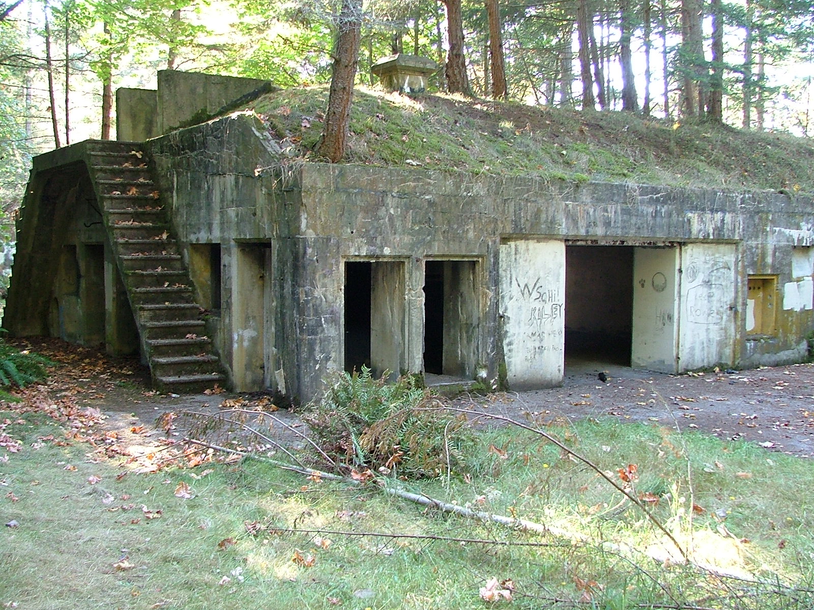
  Fort Whitman on Goat Island is a hidden set of early 1900s gun battery ruins located near the south end of the Swinomish Channel. Boaters can anchor near old wharf pilings, land by dinghy, and hike a short, rough trail to the overgrown concrete structures, which were built to defend Deception Pass and the surrounding waterways. 


If you like to explore ruins and go on easy hikes like we do, this is the place for you.


Fort Whitman and Battery Harrison were built on Goat Island in the early 1900's to defend Deception Pass and Sartoga Passage, thus protecting Puget Sound.


You will find Goat Island at the south end of Swinomish channel just before the dredged channel terminates in Skagit Bay.  ( a few miles from Deception Pass)

The battery had four six-inch guns, so the concrete structure is quite long. Originally designed to be invisible from the water and now totally overgrown, you can land your dinghy and hike up the trail in about ten minutes.


Directions

  From the dredged navigation channel on the north side of Goat Island (Swinomish Channel) look for the many pilings grouped together marking the old wharf. All you will see is a lot of rows of close together pilings with steel brackets still attached at the top. (look for the rusty old steel brackets, that's your only clue that makes these pilings look different from all the others.)Anchor to one side or tie to a piling. and then run your dinghy to shore directly behind the old wharf pilings and scramble up the bank looking for a trail heading westward.  At high tide, the beach is pretty much submerged and may not look like a place to land.  Spotting the seldom-used trail is really hard, you may do some bush whacking, just remember the battery is west of where you land and a couple of hundred feet back from the top of the cliff.  

Have fun, its a fun and very short hike up to the old battery, oh, and bring a flashlight.
it's
Goat Island, Fort Whitman, Battery Harrison, Swinomish Channel
trees have taken back the island and the fort

Goat Island, Fort Whitman, Battery Harrison, Swinomish Channel
the round pit is where one of four guns was anchored

Goat Island, Fort Whitman, Battery Harrison, Swinomish Channel
 rooms and hallways are  interconnected


If you want some  more off the beaten path places to explore, try this post.


Ten lessor known places to visit in the San Juan area


Click below for a satellite  view of Goat Island


Jan 4, 2017

How to Predict Current Direction in Swinomish Channel

    What direction does Swinomish channel flow?  

Easy answer, it flows both directions.  Sooner or later, regulars to the San Juans learn to love or hate Swinomish Channel.

  Many skippers form an opinion on their very first transit through this popular eleven mile alternative to Deception Pass. Sailors and under powered puttsters fighting the current, hate it, but turn them around and  suddenly their tune changes as the current whisks them along at 

four miles per hour.


         One day we pulled in to the city float at La Conner and I grumbled to a local boater about how we had been battling the current for hours on our way from James Island.  I remember his comment, he said, "The current flows one way for twenty three hours and then reverses, and no one knows when."  We all laughed and I figured I should get over it.


         I came across this rule of thumb posted on the Port of Skagit County website for estimating the current direction.  


        The rule of thumb for estimating Swinomish Channel current 
direction at La Conner goes like this:

The current flows   north   from 2.5 - 4 hours before high tide to 2.5 - 4 hours after high tide
The current flows   south   from 2.5 - 4 hours before low tide to 2.5 - 4 hours after low tide
Slack water occurs 2.5 - 4 hours after high or low tide, not at the tide change like in some areas.

          You will still need to consult with high and low tide predictions for La Conner to put these rule of thumbs to use.  Be forewarned, many people consider La Conner tide predictions as hocus pocus because they are often wrong.


      I cannot remember this rule so I am going out on a limb here and offering my own memory trick as follows.   We already know that in the San Juans a rule of thumb is that the current flows north on an incoming tide (flood) and south on the ebb, and we know in the Puget Sound and southern area it is basically the opposite.  So my memory hack is to consider Swinomish Channel as part of and subject to the San Juan rules of thumb.  This means, Swinomish Channel flows NORTH on the flood just like the San Juans, but it is late due to distance.


FYI - did you know that all of Swinomish Channel (at least where land is) is a "No Wake - Slow Zone"

Click below for satellite view of Swinomish Channel North end and Cap Sante

Nov 18, 2014

Swinomish Channel Nightmare in the Daytime

How deep Is Swinomish Channel?

12 feet in places, but not everywhere.   

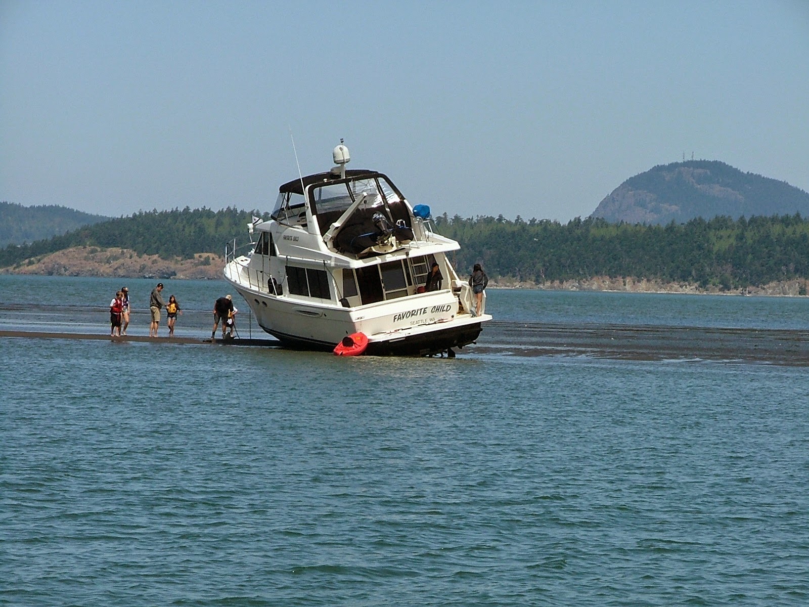
  We came across this boat during our 4th of July hike to Fort Whitman on Goat Island. 

They were barely stuck when we first saw them, but within a few minutes, it was clear they weren't getting off until the tide came back up.  I can't imagine the port prop and shaft survived,


boat aground in Swimnomish channel

If this is you, our hearts go out to you. It must have been a rotten day. (make a comment, tell us what happened below, if you want to)


Swinomish channel Fort Whitman

One of four gun emplacements at  Fort Whitman on Goat Island.
Here is the link to the  Fort Whitman posting  > Fort Whitman - Goat Island


Click below to see a satellite view of Swinomish channel

Oct 3, 2012

Swinomish Channel thin water or "A Rising Tide Floats All Boats"

    Ever heard this old saying or something like it?   

 "A rising tide lifts all boats." 

 Most of us have seen a derelict boat on shore somewhere, half-submerged, half part of the driftwood. Those boats are long past rising on a flood tide.


           Let's think about when that boat went aground.  Did the skipper intentionally run aground?  Doubtful, maybe a storm, maybe mechanical failure, possibly.  In all likelihood, someone made a decision or series of decisions that eventually led to grounding and eventual loss of the vessel. I suppose you are now thinking, that's so obvious, and your post is boring me, get to your point.  Okay,


         Okay, here is a real-life boating decision I made that others may relate to.  When planning our departure time from Shelter Bay on Swinomish Channel, I consulted my tide forecasts, noting that low tide would be around noon.  I also noted that numerous skippers have reported shoaling and groundings within the buoyed channel near Goat Island, where I was headed.  So my decision was to delay departure and time my transit so that I would arrive at the problem area, at or after low tide.


          Now, some may think that was dumb thinking, intentionally looking for thin water, and waiting until the water was the thinnest, of course, you are going to get into trouble. But they're wrong, I was thinking if I do run aground, the rising tide would soon release us, and away we go.  If, on the other hand, we went ahead and left early and still ran aground on a falling tide, we could suffer damage as the water fell further, our stranded boat with its five-and-a-half-foot deep keel could tip over, and when the tide rose, we could down-flood before the boat righted and essentially become another derelict.


           So my decision to wait a few hours may easily have resulted in another enjoyable outing, versus who knows!


         Very, very sad proof of what happens when you run aground on a falling tide  Nightmare on Swinomish Channel

          Let's see, how does the saying go?  "All skippers have run aground, or will run aground, and the rest are liars," or something like that.


        While were on the subject of decisions and choices. I would be remiss if I didn't expand a little beyond driving my boat into the dirt, but I will avoid lecturing. You can just add your own thoughts while glancing over the list below.


Decisions and Choices we make

  • PFD's "life jackets," everyone has them, but do you insist on wearing them at certain times?
  • fire extinguishers?
  • anchors
  • routine maintenance
  • alcohol/drugs
  • Second skipper (huh), can others besides you run the boat when you fall overboard
  • checklist(s)
  • float plan
  • non-swimmers
  • handling fuel on board
  • first aid and medicines
  • emergency plan, supplies
  • Go or no go into poor conditions
  • wake or no wake (huh)
Try adding to this list, I'll bet you can.

It's October, and I'm going out this weekend. How about you?
Swinomish channel thin water