ATTENTION!

This site has oodles of information about boating and the San Juans, it helps to use the search box BELOW to find what interests you.
Search - "things to do" or try "places to go"
search - Sucia Island
search - Friday Harbor
search - hiking or bicycling
try - kayak - try CAMPING - try Anchoring

++++ ============================= All Posts Below

Current Posts Below

8/23/2017

Ten lessor known places to visit in the San Juan's


     Everyone knows about Rosario - Friday Harbor - Roche Harbor and Sucia Island.  Of course they are famous and not to miss, but some of the best San Juan area destinations are much less traveled and even less talked about.  Out of the way places have secrets where local knowledge may turn a ho-hum cruise into a truly memorable event.  I am listing and describing some favorites, feel free to make them yours too.

   Not in any order or preference!

   #1  Saddlebag Island
       At the top of Guemes Channel northeast of Anacortes in Padilla Bay is diminutive Saddlebag Island State Park.

       Saddlebag has only 24 acres, its distinctive dog-bone shape creates two teeny bays. The north one suitable for  two anchored boats, or only one if the skipper hogs the middle on a long rode. We have always been able to anchor fifty feet from shore.  The dinghy ride is short and sweet, the gravel beach is friendly and steep.  The bay catches a little flotsam and wayward seaweed so an aroma may be mixed in with treasures you find.

      The narrow center isthmus holds a small campground and outhouse (newer).  Hiking the shoreline trail is easy and follows a handy figure eight shape affording views in all directions.  Being less than two miles from Anacortes makes Saddlebag an easy kayak destination.

      The waters on the east side of Saddlebag are shallow and rock strewn, circling the island is a white-knuckle event at lower tides. Your dinghy or kayak would be a better choice than the mother ship if you are determined to gunk-hole.

      We stop at Saddlebag for lunch and a hike, overnight if it is late, or just a quick anchor and hike.  We always see something new, and never go away unhappy.

       Saddlebag may only be rated as  five star, you will be glad you stopped by.

Saddlebag Island State Park


     #2 Lopez Village


     Stop, don't think that I think you don't know all about Lopez Village, of course you do.

But do you know how to land your dinghy right downtown?

     Many people, go to the Islander Resort or Islands Marine Center in Fisherman Bay and then walk or bicycle the 3/4 mile back to town. That's a long way to carry groceries or walk to breakfast, and you don't have to!

     There is a public beach access to the village just outside the entrance to Fisherman Bay and here is how to spot it and what to do.

      First you have some choices:
        #1 anchor outside the Fisherman Bay entrance, but you will be waked by other boats so this is a short term at best choice. #2 anchor just inside Fisherman Bay (no wake zone)  on the right side at the first corner, or anchor a little further in in front of Islands Marine Center or the Islander Resort.  #3 tie up at one of the two mentioned resort docks and pay the fees. I prefer option #2 because it is protected from the wind and gives easy access to the Spit Preserve.

      Once anchored or tied up to the dock, jump in the dinghy and race back outside the entrance.  Run as far as the  red navigation aid (dolphin) marking the safe entrance to Fisherman Bay and look towards shore, there you will easily spot a galvanized stairway way with switch back and viewing platform.

      Bring the dinghy ashore right in front of the stairway. The beach to the left and right are private with signs reminding us.  We drag the dinghy all the way up to the stairs and tie off on a steel support.

       Once you charge up the stairs and get your bearings you will find you are right smack in the middle of the village.  The fudge shop is fifty feet away and across the street is the free hot shower and bathroom supported by the Lopez Chamber of Commerce (donations accepted).  Another block up the road brings you to the grocery stores.  Sometimes we bring our bikes ashore here or rendezvous with others that came by ferry.

Public access stairs to Lopez Village
Public access beach and stairs for Lopez Village


     #3 Matia Island Trail

        We all have our favorite place, trail, or experience we remember fondly.  I conveniently forget the rainy foggy times, recalling just the good stuff. Matia has always been that place for me.  I once said to a fellow boater that if I was stuck somewhere due to bad weather or rough seas, Matia was where I wanted to be.

         Matia Island State Park is about one mile east of Sucia and a little more north of Orcas.

       My preferred access is Rolf Cove on the west end.  From the dock on Matia, with field glasses you can look right up Echo Bay and count the yachts at Sucia (sort of).  Rolfe cove is cute, smallish, stops most wind and rogue wakes and feels homey, private and comfortable at the dock or paddling the dinghy.  The rickety single pole gangplank and old wood float is quaint, but due to be replaced, and currently holds only four boats.  The bay has room for three or four more at buoys or anchored.

       The second less preferred but equally protected access is a large cove on the far east end, but there is no dock. (The trail is at the dinghy friendly beach at the head of the cove)

        What makes Matia special is the one mile trail circling the south half of the island. Part rain forest, part sea shore, part wildlife habitat, hiking the trail is an experience worth repeating.  It connects you with the island and with nature, it renews and grounds you..  Once you start down the, no dogs allowed path, you become immersed in the island and leave the world somewhere else.  

Matia Island one mile trail is special


Matia Island loop trail at Matia State Park


Matia Island trail near hermits cabin location
For an up close personal look at Matia, check out the
 Matia pictorial here Land and Sea around Matia

      #4 Bicycle Around Lummi Island

      Lopez Island is known as the bicycling Island because it is less hilly than Orcas or San Juan Island, but did you know that Lummi Island is flatter by far than Lopez?  It's true, the loop around the north end of Lummi is a delightful pedal along the shore the entire 7 1/2 miles.   Lummi's lack of commercial development means very few cars too, and the few you do encounter will be locals that generally drive like they live there.

        There are no public docks where you may tie up or come ashore, but there is a public park and beach where you can anchor and come ashore by dinghy.  It is a little bit of work but well worth the effort to lug your bikes ashore.  There is also a cafe and general store walking distance from the public beach.

Here is a link to a post that describes in detail  >>> How to go ashore on Lummi Island

Lummi Island  bicycle ride access point


      #5 Eastsound - the village (city)

       Eastsound is not visited much by boaters, few boats anchor or tie to the county dock even though it is the second largest town in San Juan county. Never the less, this artsy craftsy city is always worthy of a stopover. Eastsound has the largest store on Orcas Island, a dog park, a people park with live music festivals. Summer farmers markets, craft galleries, and loads of bistros.  

       Eastsound's location is great for rendezvous with friends and family arriving by car or bicycle. It is easy to spend the entire day being a tourist and then retire to the boat, a day well spent.

      When you visit, plan on anchoring and rowing over to the county dock with the dinghy since the county only allows short time tie ups and no over-nighters at the float.

      For those of you without a chart, map or gps, Eastsound is at the top of East Sound on Orcas Island.  Simply go past Rosario until you run out of water.  The dock and anchor area are in Fishing Bay on the west shore of Madrona Point.
Eastsound county dock and anchor area
The tiny Eastsound county dock is used mostly for dinghy landing, and is only one block to the village center and the largest food store on Orcas Island.

     #6  Vendovi Island Preserve

      Vendovi Island is a small island on your chart, north of Cypress and south of Lummi.  When heading out from Bellingham you probably steer around it on your way to the inner islands.

       The entire island was once a private home-site, hence has never been developed. The single modest home is where the caretakers live and is off limits, the rest of the property is forest with trails leading to view points and meadows around the island.

       Access is on the islands north end where a breakwater forms a bay protecting a nice float. Admission is free.  This is a good place to break up your cruise and spend a few hours walking on shore or just have lunch in the gazebo.  Comical Puffins live in the rocks of the breakwater and are sure to entertain you.
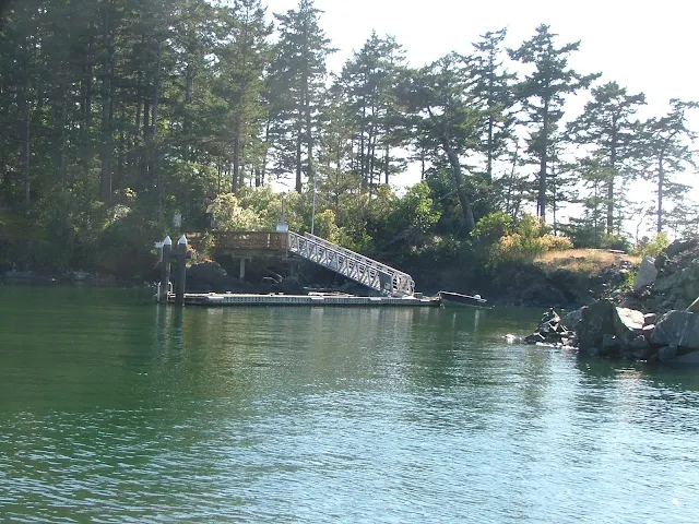
Vendovi Island free public dock to access Island hiking trails
Vendovi Island float


Vendozi Island


       #7 Fort Whitman on Goat Island

      Fort Whitman and Battery Harrison easily win the battle for least visited and are virtually unknown except to locals. There are no signs, no brochures, no promotion.  Even the state of Washington seems loath to admit its existence or encourage tourism.

     According to online sources, Goat Island is managed by Washington's department of fish and wildlife, visiting is not restricted, although they prefer to not talk about it. 

     For gunk-holers and true explorers, Fort Whitman is tops and it is unbelievably easy to get to and access. 

      Follow this link to a posting detailing every last detail you need to check this place out.  You will be glad you added it to your - must see/do list. Your inner child will love it.

Click here to go to >> Fort Whitman on Goat Island

Fort Whitman Goat Island Battery Harrison on Swinomish channel
Battery Harrison at Fort Whitman on Goat Island


Last on my list of lessor known places to visit are hikes - I mean real uphill hikes, the kind that work up a sweat and you are really glad when you finally arrive at your destination.


#7 Young Hill

     Start this hike at English Camp on Garrison Bay.  Begin by anchoring near the tiny dinghy dock, please don't hog the entire dock with your big yacht.  Wear your hiking shoes and bring plenty of water, your going to drink all of it.

        Check out the interpretive center, and grounds if this is your first visit and then get going. Walk up the trail to the parking lot and then rejoin the trail at the top of the parking lot.  From now on you can't get lost or miss the trail, just keep going up, up, and up some more.

      When you get to the top, it is a false top, take a break and then follow the trail up another five minutes, up to the real top.

        Noticeably absent on this two hour hike are resting benches, use a handy rock or stump.  Perhaps the smooth wide trail and welcome shade trees, make up for a lack, of rest stops, you decide.
view from Young Hill overlooking mosquito pass and Garrison bay
View of Garrison Bay from Young Hill, Mosquito Pass is barely visible,
beyond is Haro Strait, Sidney Island, and then Vancouver Island


        #8 Cypress Lake on Cypress Island

       This is the longest loop hike I know of except Turtleback Mountain and the hikes in Moran State Park which of course are not accessible by boat alone.

        The trails on Cypress interconnect making long and varying hikes possible.  The most straight forward access to Cypress Lake is by anchoring or hooking one of 18+  buoys in Eagle Harbor, and then dinghy ashore landing at a small gravel beach on the south shore of the bay.  It is an easy to spot landing because it's about the only place without grass and muck, plus there is a DNR rules and regs. sign to greet you complete with a free trail map if you are lucky. (don't steal the posted one, that's not nice)

       Much of the trail to the lake is not really a trail, it is more like a rutted jeep road that steadily climbs to about 1,000 feet in a little less than two miles.  It is a grinding workout but not too bad, the lake is just so so,  but never the less a good destination. I don't know about fishing, let us all know in comments if you have fished it.

        On the way back down be sure to take the loop side trail that leads to the old airstrip and winds through the woods past a small unnamed lake that is warm and people swim in.  The once, panoramic view from the airstrip is all but gone as planted trees take hold, but the hike is a good one anyway.

        I strongly suggest that you go online and find a map to print and take with you, my description will get you to Cypress Lake just fine, but the other trails are just waiting.
Cypress Island trail map
Cypress lake hike on Cypress island
Cypress Lake


    #9 Eagle Bluff on Cypress Island

    This is possibly my favorite hike and I must warn you right off that hiking to the bluff is not allowed until after July 15 each year. Apparently people affect the baby birds. Sometimes we plan our schedule so we can make this hike.

Eagle bluff aka Eagle Cliff from Rosario Strait on Cypress Island
Imposing Eagle Bluff 

       Eagle bluff overlooks Rosario Strait giving you great views north and south down the waterway and of course of Orcas Island.  The trail is in good shape with handy steps and a short five foot ladder at a particularly steep section. As you hike you will see peek a boo peeks at clearings and drop offs, but nothing dangerous until you get to the very top, then watch your step and grab the children and pets.  If you are patient or fortunate you will see eagles and ospreys soaring in the updrafts, sometimes in mock aerial attacks with siblings.

       Access this extraordinary 1-2 hour hike from Pelican Beach, you won't need a map the trail is well marked.

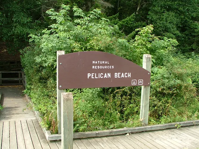
     Pelican Beach is near the north end of Cypress Island facing Sinclair Island.  It is one mile north of Eagle Harbor, there are picnic tables on shore a DNR sign and a restroom in the woods. Off shore are four or six anchor buoys. You can't miss it.

Free camping at Pelican Beach on Cypress Island

Pelican Beach


       Follow the link below to a posting full of pictures.
Eagle Bluff pictorial hike

Oops, did I say ten?  Okay, try #10 - Sharpe Cove at Deception Pass
click here >> Sharpe Cove

Sharp Cove, Bowman Bay, Rosario beach, Maiden of deception Pass
Maiden of Deception Pass at Sharpe Cove.


That's it, if you go see these ten places and also hit the biggies like Roche and Friday Harbor, Jones, Sucia and Stuart, etc., you will have years of great cruises.


A critic once wrote:

 "All the author has done is write about his favorite places"  Yes, that's exactly what I have done.
John -

8/01/2017

Bicycle ride from the Lopez Island County Dock at Hunter Bay to Iceberg Point on the Strait of Juan De Fuca


       We  spent the night at the dock on James Island.  Our plan was to ride the morning current south through Lopez Pass and over to the county dock on Hunter Bay.  Next we would unload our bicycles and ride to Agate Beach where we would then hike to Iceberg Point.  If time permitted after returning to the boat, we would whale watch while cruising up Haro Strait on the outside of San Juan Island to spend the night at Garrison Bay or Roche Harbor.  This seemed like an ambitious but doable first full day of our loosely planned vacation.

         We left James late (9am) and arrived at Hunter Bay early (9:45), which is what happens when you are only going 4 1/2 miles.

          Spotting the  small county dock from a distance was difficult because a little rocky islet blocked our view until we were right on top of it.  Half the boat hung out from the  tiny cargo loading space, but we got the bicycles off without any problem, and then moved away and anchored in ten feet on a rising tide.


Hunter Bay, county dock and launch ramp on Lopez Island
This county dock and ramp is for public use, but is primarily used by nearby local residents.  Like all county docks, you may not spend the night but we see boats tied up all day and all night anyway.  Under the gangway is a spot for dinghy's and next to the bicycles is reserved for loading and unloading only.  Anchoring nearby is easy and the bay is well protected except from northerlies.


Kraken anchored near Hunter bay dock on Lopez island
In the far distance you can see Orcas Island, so any north winds building waves will be coming all the way from Eastsound and can be a touch big, just like southerlies coming from Hunter Bay tend to be uncomfortable when they reach the top of East Sound -- touche'
Southend Store and restaurant is about a two mile walk with a pretty significant hill to go up and over.  Off to the left where the cove is  more protected are a number of cruisers bedded down.  All in all, this is a pretty peaceful place to hang on the hook or come ashore.

   We tied up in the already crowded dinghy spot under the gangplank.  Watered, sun screened and raring to ride to Iceberg Point, we pedaled a few hundred feet and ended up walking up a rather steep hill the first 3/4 mile.  It was a nice forested walk, we mingled with baby deer and glimpsed homes nestled around towering trees.  Still pushing our bikes, we crested the hill only to find another much smaller hill. Finally we started coasting at flank speed down the other side and I'm thinking, oh boy, we have to come back over this mountain later today in blazing afternoon sun.

            Once out on the islands only south end main road, we merged with and then were left in the dust of several large  bicycle excursion groups complete with chase vans and guides.  We caught up with them resting at Southend Store only to have them fly by us again on the way to Agate Beach Park.  At Agate Beach we may have accidentally photo bombed them while they posed for group photos.  We pushed on for a quarter mile and padlocked the bikes at the trail head to Iceberg Point.

           We are almost at the half way point of our days planned bike/hike, all we have to do is walk the mile or so out to the point and back, then head for the boat like a horse to its barn.  I want to call Uber.

          I will save the  details about Iceberg Point for another day except to say it is the tip of Lopez  Island facing the Strait of Juan De Fuca, and I think it was a great  worthwhile place to visit.  I also think it would be a very miserable place on shore in a storm and downright dangerous off shore in small craft. Our day so far, was balmy and near perfect. 

         On the way back we were overtaken again by fit and trim excursion bicyclists, each one wishing us a good day as they sped by. The ones riding tandems seemed extra peppy.

        We stopped at the same store/restaurant on the way back, no other bicyclists were in sight. I had been talking about getting a hamburger, coke and fries since leaving Iceberg Point.  We sat down in the restaurant portion of the store at a table with a checkered tablecloth  loaded with chips and salsa. I picked up the Mexican only menu to find pages of burritos, enchiladas and nachos. The hamburger and fries will have to wait.  The pulled pork burritos we ordered were huge and the warm salsa was out of this world good.

       I was ready for Uber or even a stranger with a rusty pickup when we saddled up for the last time an hour later, but the hill coming back was not as steep and we pedaled all but a short section, making it back to the dinghy and Kraken in short order.


Iceberg Point on Lopez Island
Iceberg Point Nav. aid. In the background is Cattle Pass and San Juan Island, beautiful calm day with a little lingering low haze. Across the Strait of Juan De Fuca we were treated to the snow capped Olympic mountains


Iceberg Point from cattle pass


The same nav-aid viewed from the water hours later as we head north hoping to spot orcas, still a flat hazy day. You don't have to ride bikes from Hunter Bay like we did, you can anchor at Agate Beach and make the easy hike out to Iceberg Point.


chart of Agate Beach  Iceberg Point Hunter Bay
There is no dock at Agate Beach but you can anchor right in front of the stairs
and hike the short distance to the Iceberg Point trail head.
The bike ride from Hunter Bay to Iceberg Point is enjoyable and takes you by Southend Store for a handy lunch stop or in my case - directions.

       Our bike and hike was just about perfect, we will  do it again someday. All together we pedaled about 7 1/2 miles, and walked 1 or 2. After loading up we headed leisurely around the south end of Lopez fighting a small current until we cleared Cattle Pass where we got a little boost all the way through Mosquito Pass.  We took a slip at Roche Harbor in time to watch the "Lowering of the flags" ceremony.  When they fired the canon, my day was complete.  I slept well that night.


7/15/2017

Five Tips for Bicycles and Dinghy's in the San Juan's

     If you limit yourself to places with docks to offload bikes you are also missing out on some of the best places worth exploring.  Learning to haul bikes in the dinghy opens up a world of  onshore expeditions.

     Furthermore, if you are planning to use a dock to unload bikes, and the dock is for whatever reason, ie. crowded or out of service, there go all your well thought through plans, out the window and in the drink.

     Prior to heading out you should experiment with ways to load bikes into the dinghy.  You do not want to learn the hard way what not to do. Poking a hole in the favorite and likely the only inflatable would be the hard way.  I think type four seat cushions will protect an inflatable, but I have never tried it since my dinghy is fiberglass.

     Plan ahead, one time we sewed up huge bicycle bags from tarps to protect our bikes during an extended trip we knew may have salt water cascading over us.

Tips:
  • Bring your old bikes if possible, saltwater means rust. Flush and wash asap afterwards.
  • I accept that I will be wading in ankle deep water when reaching shore, so I wear sandals.
  • Bike chains, pedals and spokes will get snagged, be patient and  super careful not to do damage while transporting and untangling a mess.
  • I bring a tire patch kit, basic tools and pump.
    • plus I use that anti leak slime stuff in all my tubes.
  • Many of our bike rides end up as hikes where we leave the bikes unattended so we bring a cable and lock.  It's not that I don't trust people, I just don't want to risk walking miles and miles back to the boat.
Bikes stacked in dinghy for going ashore
Going ashore we took two at a time, which meant three round  trips for four people.  Upon coming back, Ryan suggested we try stacking all four bikes which meant only two trips.  Count them, it worked fine. The dinghy is a nine foot Livingston.

6/20/2017

Anchor Rode Marking

       Why mark the anchor rode?  Easy -- sooner or later you will wonder how much line is out.

         In my opinion, marking the rode is not hard nor costly.  Suppliers sell tags, with footage numbers, some people use cable ties or bits of yarn.

        Some exuberant skippers, mark every twenty five feet and use day-glo colors.

        Years of anchoring in the San Juans has honed my system, or should I say reduced it to what works for me.


      My obvious observations:

  • Anchoring, like coming in to the dock or slip must be done fairly quickly or the boat floats away.  This means doing math calculations or untangling snarly rode should be completed beforehand.
  • Under water, red, black,and other colors look the same or just disappear.
  • Trying to spot, cutesy paint marks, little tags or bits of string flying out of the hawse pipe is problematic, especially for newbie crew.
  • Guesstimating how much rode has been let out is not accurate, but is never the less the system I used for years.
  • I tried using a code, such as two marks, three marks, four marks to designate small increments. It was confusing, hard to keep track of, and kinda pointless anyway since I forgot the code.
  • Anchoring in dark or windy conditions, or stiff current, quickly identifies inadequate systems, poor planning, and lack of preparation.
     What I do today:
  • My experience has been that all paints I have tried last only one season in salt water. Now I  use whatever left over black or red latex paint or spray paint I have. I apply it on a three to four foot section.  
  • My first mark is at fifty feet, then one hundred, then one fifty, etc. Since I usually anchor in 15 - 20 feet the third mark never sees water and stays in good shape.
  • If I suspect problems or crucial timing issues, I will pull all the needed rode out of the locker and cleanly flake it on deck beforehand.
  • When I up anchor, if conditions permit, I flake the rode on deck for cleaning and drying and then carefully drop it in the locker later. Sometimes I put my thirty feet of wet or muddy chain in a milk crate and leave it in the sun.  Putting away wet gear tends to stink, so I avoid it when  I can, especially if I plan to anchor again that day.
  • I have a pair of dedicated gloves I use for anchor handling.
anchoring in the San Juans
How well I anchor is proportional to how well I sleep!


5/26/2017

Visit Vendovi Island Preserve

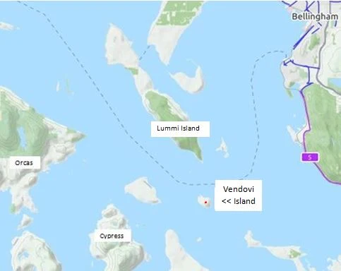
       For years all of us have been going around Vendovi  Island on our way to Sucia or the inner islands.  If you are thinking Vendovi sounds familiar but can't quite place it, I will tell you - it is the little 200+ acre dot on your chart due south from the southern tip of Lummi Island.  200 acres is about the size of Jones Island if that comparison is of any help.  The map clipping below should help you zero in on Vendovi's location.

        The San Juan Preservation Trust has owned and protected Vendovi Island since 2010.  Visiting  days are  April 1st through Sept. 30.    Open hours are 10 am to 6 pm, Thursday through Monday. They are closed Tues. and Wed.

        Access is a small cove at the north end.  There is a 70 foot, first come no reserve dock behind the breakwater, or you may beach kayaks and dinghy's in front of caretaker home if the dock is full. No anchoring in the cove or overnight stays at the dock are allowed.

      Bring your hiking shoes and plan to immerse yourself in unspoiled wilderness, but you should stay on the trails if you  truly respect the wilderness and the SJPT mission to preserve.  No camping, fires, bicycles, or hunting, pets are to be on leash.  Enjoy!

San Juan Preservation Preserve Vendovi Island


      Learn about the many San Juan Preservation Trust  preserves  here  >> Map of SJPT preserves

5/08/2017

Is disaster simply one little mistake away?

 This is a short accounting of what we watched evolve on a balmy calm peaceful Sunday afternoon. The gentleman side tied behind us cast off, he said he was going to swing by the pumpout on the other dock and then head for home. I waved from our cockpit and dove back into my magazine. Suddenly my concentration is interrupted by a revving engine. "Somethings wrong," I said to Linda, "look over there." The boater that had just left had entered the next fairway, the current was dragging him towards the two foot high aluminum footbridge that connects the walkways.  "He's in trouble," I said, "the currents too much and he can't complete the turn."  Next, to my surprise he guns the engine of his thirty footer, full throttle, attempting to make a 180 degree turn before he strikes the walkway.  His boat does indeed miss the footbridge and almost completes the turn but instead, he hits the dock next to the pumpout and with engines screaming, he drives the as yet undamaged boat  three quarters of the way onto the dock.  Not quite out of the water and at a steep angle he slams it into reverse.  The boat instantly pulls off the dock, sliding back into the water. Now mostly turned around, the boat powers backwards towards the footbridge.  The unmistakable sound of crunching fiberglass is heard a split second afterwards as the driver finally throttles back and then kills the engines.

The whole sad episode is over as fast as the engines could rev up.  By the time I and some other onlookers get over there with our boat hooks the boat is back in the water floating peacefully next to the pumpout. What can you say to someone that has just trashed their boat in a frenzied show of dumb mistakes compounded by more dumb mistakes.

Speaking for myself and probably a few other skippers that have misjudged currents and our boats handling or lack of handling.  I will say, I too have gunned the motor in a last ditch effort to clear an obstacle. I may even have bumped a few times.  Luckily I have never done any real damage or I have suppressed the memory.

Experience teaches us lessons, sometimes expensive lessons. In this instance, one lesson learned is to not try to turn around upstream of anything you don't want to hit. In lieu of that, don't hit it at full throttle.

In this situation two alternative actions come to mind. #1 the driver could have turned his boat around outside the fairway and backed down to the pumpout, although he would still run the risk of crashing if he lost power or control in the strong current. #2 and a better choice, would be to choose another location or wait for a tide change.  Sometimes it is best to not push your luck.


4/27/2017

How to tie to an anchor buoy in the San Juan Islands Marine Parks

      This may seem like a no-brainer, but  watching crews struggle while tying up in a calm mooring field  says otherwise.   Aside from the entertainment angle,  lessons may be learned.

        The basic anchor buoy is often simply an old foam filled tire with some sort of strong attachment ring on top, but smart skippers approach unknown buoys with caution and skepticism.

        This list of dos and don'ts are suggestions, and observations, not rules, and may not apply to your boat, your gear, or your crew.

  • Anchor buoys may not be in deep water, in fact you may run aground on approach.
  • Don't bang into buoys, they may have sharp edges, and gel coat slashing barnacles.
  • Many buoys (most in my opinion) have large amounts of plant life growing and trailing from them.  
  • Some buoys have abandoned lines tied to them, ready to foul your rudders and propellers.
  • You can't stand on them, they won't support your weight, even for just a second while you grab the ring.
  • Buoy components corrode and break and then they float loose, it is a fact!  Seaweed might be all that is holding it together.
    • Therefore backing down on a buoy, just like setting an anchor, is a good idea.

       Tips based upon my experiences: 
  • Approach buoys dead slow from down wind and current, and off to one side.
    • Check it out - make sure there are no long trailing lines or bits of flotsam hanging in the buoys wake.
    • Match your rpm's to the current and wind so your boat is stationary next to it before moving over.
    • If your boat has low freeboard, have your crew reach the ring and thread a line through it and back to a cleat.  Don't tie fast to the buoy or use a snap hook or shackle or biner, you want to be able to release it from the boat, possibly in an emergency. Use a heavy line, it will chafe at the ring.
      • Is your line already tied at the other  end?
      • Is your crew wearing a pfd?
      • Make sure the crew cleats the line before you release your helm control, the current or wind may be more than they can hold by hand.
    • If your boat has high freeboard, instruct crew to use your boat hook to snag the ring, but make sure you are holding stationary.
      • Many anchor buoys are designed with a lifting ring and chain that you may pull up several feet out of the water enabling you to slip a line through.  Sometimes lifting a heavy chain is a two man job.
        • If enough seaweed is growing (attached) on the chain, it may be impossible to lift the ring, even with ten crew.
        • WARNING - If the skipper leaves the helm to help, allowing the boat to drift with the current, they still may not be able to lift the ring or hold against the current.
          • The boat hook may get pulled from their hands or not be possible to easily unhook for a retry.   This results in losing the hook as soon as the buoy is grabbed  - another good reason for having a floating hook and wearing pfd's.
          • You may also pull the boat hook apart or break off the end.
    • Most boats have lower freeboard in the cockpits than up on a high bow and simply grabbing the ring from the cockpit may be all that's required.
      • But, watch out when working from stern!
        • The boat will be much harder to control, you may tangle with propellers and rudders.  Once hooked, the boat will likely spin in the wind and current increasing difficulty and strain on lines.
  • Do not treat anchor buoys like fixed docks or floats.  They are simple to use, but can bite the unwary.  
  • Lastly - don't forget that the anchor buoy has its own anchor and rode that you could tangle with, especially if you set your own hook nearby.
mooring anchor buoy
White with blue band is the official anchor buoy marking.

mooring buoy broke loose at Jones Island
Close inspection reveals missing  shackle pin set this buoy free at Jones Island 

cypress island free anchor buoy
The mooring buoys and campsites are free at Pelican Beach, Cypress Head, and Eagle Harbor on Cypress Island

4/03/2017

How to go Ashore on Lummi Island for Bicycling or just going to the Store


For some time I have advised cruisers to use Inati Bay on Lummi Island as a storm refuge and lunch stop, or a very convenient anchorage when they don't have time to make it back to Bellingham or Sucia.

If you have the time you should consider going ashore, but not at Inati Bay where all the land is private and only has a logging road at that.

Follow these simple instructions for getting to shore on Lummi Island at the public access beach.

About three miles north of Inati Bay is the Whatcom Chief Ferry terminal. The tiny but speedy 25 car ferry makes several Hale Passage crossings every hour, so you will see it for sure.

Head for the ferry terminal and about one football field length north, anchor your boat in front of a  long stairway leading up the bank.  At the top of the stairs where the old car deck and ramp once was is a rustic wood deck, turned into a public park complete with picnic tables.  All the pilings are gone, there is nothing left, your only landmark will be the stairway with the Beach Cafe in the background.  Beach the dinghy, not forgetting the current and tides, offload the bikes and clamber up the stairs.

The local anchor buoys are quite a ways from shore suggesting thin water, you are well advised to follow their lead and anchor far off as well, unless your stay is short.

Across the street (Nugent Road) is the Beach Cafe, turn left, south on Nugent and it is 1300 feet (1/4 mi) to the Islander Grocery Store. (just past the current ferry terminal.)
Lummi Island shore access stairs
Look for public stairs and Beach Cafe. Land your dinghy on slab rock or gravel at low tide.
Driftwood suggests high tide reaches to stairs.
Lummi Island waterfront public access
Mt Baker across Hale Passage is a great backdrop.


That's it -- for bicyclists head left or right on Nugent Rd and circle the north end of Lummi.  It is an easy (not too hilly) 7 mile loop that takes you around Migley Point, Legoe Bay, and  West Shore Drive with sweeping vistas of  Rosario Strait.

Lummi Island shore access map

Some first mates may find the rule of twelfths handy when anchoring in the shallows off the stairway. Below is the link to refresh your memory of how it works. Don't forget that the current changes 180 degrees and may unhook you.  I set two longish rode anchors (boat in the middle) before I take off for an extended time if I anticipate current shifts. 
Note: expect wakes from ferry to rock you mercilessly every thirty minutes.


3/12/2017

Marine Parks of the San Juan Islands and Surrounding Area


Below is the marine parks list
             followed by reviews, charts, and pictures
                         in the order listed.
        This is not all the parks, just the ones you may want to make part of your cruising. It's unlikely you can visit all in one trip and still do a decent job of sightseeing. You should plan multiple visits to the San Juans.
Many people choose Jones as their favorite for just hanging for a few days, so Jones is first.
For hiking, Sucia, or Pelican Beach on Cypress Island are the best, but all the parks have hiking trails.
      Some parks are in a convenient location when you need to spend the night and you're between destinations, Saddle Bag, Eagle Harbor, and Odlin would fit this description.  Most parks with docks have picnic tables on the floats, which are very handy for extending your living area, socializing, and meeting other boaters.
        For marinas/etc. where you can get fuel and provisions try this list >> Marinas - fuel - beer and ice - slips for rent

  • Jones Island
  • James Island
  • Clark Island
  • Doe Island
  • Obstruction Pass
  • Pelican Beach
  • Eagle Harbor
  • Cypress Head
  • Matia
  • Patos
  • Sucia
  • Stuart Island  (Prevost & Reid Harbor)
  • Spencer Spit
  • Odlin County Park
  • Washington Park
  • Deception Pass Park
  • Saddlebag Island
  • Sidney Spit Marine Park (Canada)
Click here to go to complete description and maps of above listed parks

2/14/2017

4th of July in the San Juan Islands - Fireworks - Parades - Celebrations

Here is a list of independence day celebrations, parades and fireworks planned on Lopez, Orcas, and San Juan Island.

     Reserve a slip at the Friday Harbor Marina, but if you just show up, there is always room for another anchor and the paddle over to the dinghy dock is super short. (FYI -  anchoring in the cove places you directly in front of the fireworks barge -- there is no better or closer view possible for your independence day grand finale)

           We had such a fun time last year at Friday Harbor celebrating the Fourth of July that we are going back for a vacation cruise repeat in 2017.    

Don't limit yourself -- below is a list of Orcas, San Juan, and Lopez island fireworks and celebrations planned for the 4th.
Some of the festivities are for different dates so with a little planning you can attend several events.


I copied some of these snippets from last year (so the dates are wrong for 2017 and some events may be altered) 
You may read about the entire year of events right here >>  >> Chamber of commerce for San Juan Island

Roche Harbor Resort Events on the 4th of July


Enjoy the Family 3.3K Fun Run, log-rolling contest, blindfolded dinghy race, doughnut eating contest, children's games, live music and fireworks.

Fun Run at Yellow Brick Road

Kids Games at Pool Lawn 12:30-2:30 p.m. - Doughnut Eating at West Lawn

Blindfolded Dinghy Race 4:00 p.m. - Log Rolling at Wharf Building

Fireworks Show in the Harbor at dusk!

Friday Harbor: on the 4th of July

Monday, July 4, 2016  All Day

​Friday Harbor's 4th of July highlights include a small-town parade, a community picnic, live music, dancing and fireworks! The parade, known as one of the top 10 small town parades in the nation, passes through downtown Friday Harbor at 10:30am. Immediately following the parade, the 'Pig War Picnic' put on by the Kiwanis, will be held at the San Juan Historical Museum grounds. Expect live music and a great lunch. At dinner time, the Port of Friday Harbor will be putting on music in the Port parking lot, followed by the biggest and best Fireworks show beginning at dusk, approximately 10:00p.m.


Orcas Island: for the 4th of July (check dates)
Orcas Island chamber of Commerce


July 1. Orcas Community Parade. Sponsor: Orcas Island Chamber of Commerce
July 3. Deer Harbor Fireworks. Sponsor: Bellport Deer Harbor Marina

July 4. Eastsound Fireworks. Sponsor: Orcas Island Chamber of http://orcasislandchamber.com/Commerce


Lopez Island: on the 4th of July
Lopez Chamber of Commerce - calendar
fireworks are at Fisherman Bay on the 4th


I copied this from the Lopez Chamber website, there is a lot more planned during the year, music, food, art etc.

Event Description

The 4th of July on Lopez Island has become one of Washington State's most treasured celebrations. Many come from all over the country to enjoy a "down home" themed parade and one of the most spectacular community funded fireworks displays you can find anywhere. The island rolls out the red carpet every 4th of July when they host what has become one of the "don't miss" events associated with the beautiful San Juan Islands. Make sure you plan ahead as it has, for good reason, become the busiest time getting to and from Lopez and lodging can fill up quite early in the year. What really makes this great event a success year after year are the multitude of volunteers and generous donations from both local businesses and individuals throughout the local community and families who come to Lopez to enjoy the show year after year.

Join us, for what has grown into a larger than life tradition, this 4th of July. It's a day packed with many events and activities, not to mention an island full of patriotism.

More Info: www.lopezfireworks.com
http://www.lopezisland.com/index.htm


Our new "Land and Sea Guide" is packed with suggestions,
and outside the box ideas
for getting around the San Juans.


San Juan Islands Travel Guide 
Amazon - Books available now

1/15/2017

Take What you Have and -- GO

      As the primary irritant and contributor to this website, I am drawn back to promoting boating and the San Juans.

        How many times have you heard  (or said yourself)  "I can't because...."   -- finish the statement with any handy excuse for not making that long talked about trip.  In many cases, the excuses I use are bogus or easily overcome.

For instance:

  • The no money excuse:
    • If you are dead broke, I suggest that you forge ahead and make plans anyway, things have a way of working out.
    • Reduce the budget some,  try dialing back what you really need to get going to the San Juans.  
      • New radar - NO, new motor - NO - how about used? New plotter - NO.  You may be  hopeless if you need all the newest toys to vacation or go on a boat ride.

  • The no boat excuse:
    • Take what you have, or consider renting or buying a used runabout or skiff.
      • One time we came across a couple (a well seasoned couple I might add) at Pelican Beach.  They arrived in an 8' plywood sailing pram (with oars and no motor) and they had towed another 8' pram with  camping gear.  They told us they had put in at Anacortes and were spending a week as they had done for many years.  I was  impressed and somewhat embarrassed for my boat full of goodies, and creature comforts.
                Let's expand on the idea of buying a used boat.  Once a few years back, I sold our primary boat just a few weeks before a planned trip to the San Juans.   Now boat-less, except for my beloved 9' dinghy, I was faced with canceling my family vacation. Instead, I decided to buy an inexpensive boat, and use it once for our  San Juan trip and then sell it upon our return.  I bought a small well known   readily available sailboat and trailer.  We boat camped for ten days, and then  I sold the temporary boat for 100% what I paid for it. 
          The overall cost for that trip was just the cost of fuel and provisioning.  I know, some people will criticize the wisdom of taking an unknown boat, breakdowns, blah blah blah. Thats OK, I agree what we did is not for everyone, but it worked well for us, and besides, I brought my dinghy and trusted 5hp Honda as back up.

  • The no time excuse:
    • Baloney - If you really want to go you will make the time, so go mark your calendar right now!

  • One last thought; life happens, when everything in life gangs up on you conspiring to stop your boating trip, don't give up.  Instead, postpone the boat part and go in your car. Camping or resorting around the San Juans is almost as good as boating around the San Juans.

Take what you have and -- GO!
San Juan Islansd Ferry with Mt Baker


     My new travel guide may be just what you need.  That's right, I am shamelessly promoting my 2017 "San Juan Islands Travel Guide" -- It is a Land and Sea Guidebook, so whether you are a boater, biker, or car camper, it has what you want.   CLICK HERE   or search Amazon Books - "San Juan Islands Travel Guide"
Thanks - John


1/04/2017

How to Predict Current Direction in Swinomish Channel

        Sooner or later regulars to the San Juans learn to love or hate Swinomish Channel.  Many skippers form an opinion on their very first transit through this popular eleven mile alternative to Deception Pass. Sailors and under powered puttsters fighting the current, hate it, but turn them around and  suddenly their tune changes as the current whisks them along at four miles per hour.

         One day we pulled in to the city float at La Conner and I grumbled to a local boater about how we had been battling the current for hours on our way from James Island.  I remember his comment, he said, "The current flows one way for twenty three hours and then reverses, and no one knows when."  We all laughed and I figured I should get over it.

         I came across this rule of thumb posted on the Port of Skagit County website for estimating the current direction.  

        The rule of thumb for estimating Swinomish Channel current direction at La Conner goes like this:
                 
The current flows north from 2.5 - 4 hours before high tide to 2.5 - 4 hours after high tide
The current flows south from 2.5 - 4 hours before low tide to 2.5 - 4 hours after low tide
Slack water occurs 2.5 - 4 hours after high or low tide, not at the tide change like in some areas.
          You will still need to consult with high and low tide predictions for La Conner to put these rule of thumbs to use.  Be forewarned, many people consider La Conner tide predictions as hocus pocus because they are often wrong.


      I cannot remember this rule so I am going out on a limb here and offering my own memory trick as follows.   We already know that in the San Juans a rule of thumb is that the current flows north on an incoming tide (flood) and south on the ebb, and we know in the Puget Sound and southern area it is basically the opposite.  So my memory hack is to consider Swinomish Channel as part of and subject to the San Juan rules of thumb.  This means, Swinomish Channel flows NORTH on the flood just like the San Juans, but it is late due to distance.

FYI - did you know that all of Swinomish Channel (at least where land is) is a "No Wake - Slow Zone"


11/14/2016

San Juan Islands Kayak Campsites and Launch Points - GPS

 Campsites and Launch places for kayakers

kayak launch and campgrounds in the san juan's, marine trail

Below and on map are campgrounds for kayakers
San Juan area kayak launching and campground list cascadia marine trail
 Black labels below and on MAP - are kayak launch sites - most with parking


10/02/2016

You should ride "San Juan Transit"

    It's not too early to be making plans for your next trip to the San Juan's.
Part of making workable plans is knowing what your options are.  If all you want to do is sit on your boat in some secluded hideaway, then stop right now.
   
           If on the other hand you think about what new excursions wait you if you just had some way to get around, keep reading.

         Did you know that San Juan Transit runs a "Sunset Tour" from Friday Harbor to Lime Kiln?  It takes about an hour.

         Did you know that you can ride your bicycle to any point they service and then come back on the little bus if you are too tuckered to ride back?  5 bucks, and if it's raining, still 5 bucks.

        Here's an idea, I'm going to do.  I'm going to start out by riding to American Camp, Then hop the transit over the mountain to English Camp, then ride to Roche and then catch the transit back to Friday Harbor.

     San Juan Transit carries bicycles on the front and if they have  more they bring them inside.
one way fare is $5, all day is $15, two day is $25.


      With a little creative thinking outside the box and free inter-island ferry service, you can get off the boat and expand your horizons.  Sit down with a ferry and transit schedule and see what you can come up with.  (they are both online)
 Daily, May 20th to Oct 6th (2016) - Before waiting for the bus, check the most recent schedule at  http://www.sanjuantransit.com/schedules.html or call 360 378 8887
     

Lopez Island Transit stops - Weekend service only on Lopez - June 21 to Sept 7

Ferry Landing – Odlin Park – Lopez Farm Cottages – Lopez Village – Golf Course – Shark Reef Park – South End Gen Store – Lopez – School – Hummel Lake – Spencer Spit State Park – Lopez Village Market –


Orcas Island Transit stops - Weekend service only on Orcas - June 17 to Sept 5

Ferry Landing – West Sound – Turtleback Mtn. Trailhead -  Deer Harbor – Golf Course – Eastsound Market – Rosario Resort – Moran St Park –

San Juan Island Transit stops - Daily service, May 20 to Oct 6 (2016) 
See spring , summer, and fall schedules 

Friday Harbor ferry – American Camp – Lavender Farm – Lime Kiln/Whale Watch St Park – SJ County Park – Snug Harbor Resort – Krystal Acres Alpacas – English Camp – Sculpture Park – Roche Harbor Resort – Lakedale Resort – San Juan Vineyard

Sunset ride from Friday Harbor to Lime kiln and back. Be at the stop 3/4 hour before sunset.
Friday Harbor stop is the little foot passenger island opposite  the ferry waiting lanes!
Orcas Isalnd - Lopez - San Juan Transit


9/15/2016

Cattle Point Resident

     Look who we met on the edge of the road while biking to Cattle Point and American Camp?

     We are on the high bluff overlooking Cattle Point and the Strait of Juan De Fuca with nothing but grassy fields in all directions.  This healthy looking guy appeared to be looking for handouts.

Fox at cattle point
Fox at cattle point
Fox at cattle point
I have never seen a fox that hasn't seen me first and wasn't running for the hills.


Another good reason for getting off the boat.